Morgan Point Topo Map Texas
To zoom in, hover over the map of Morgan Point
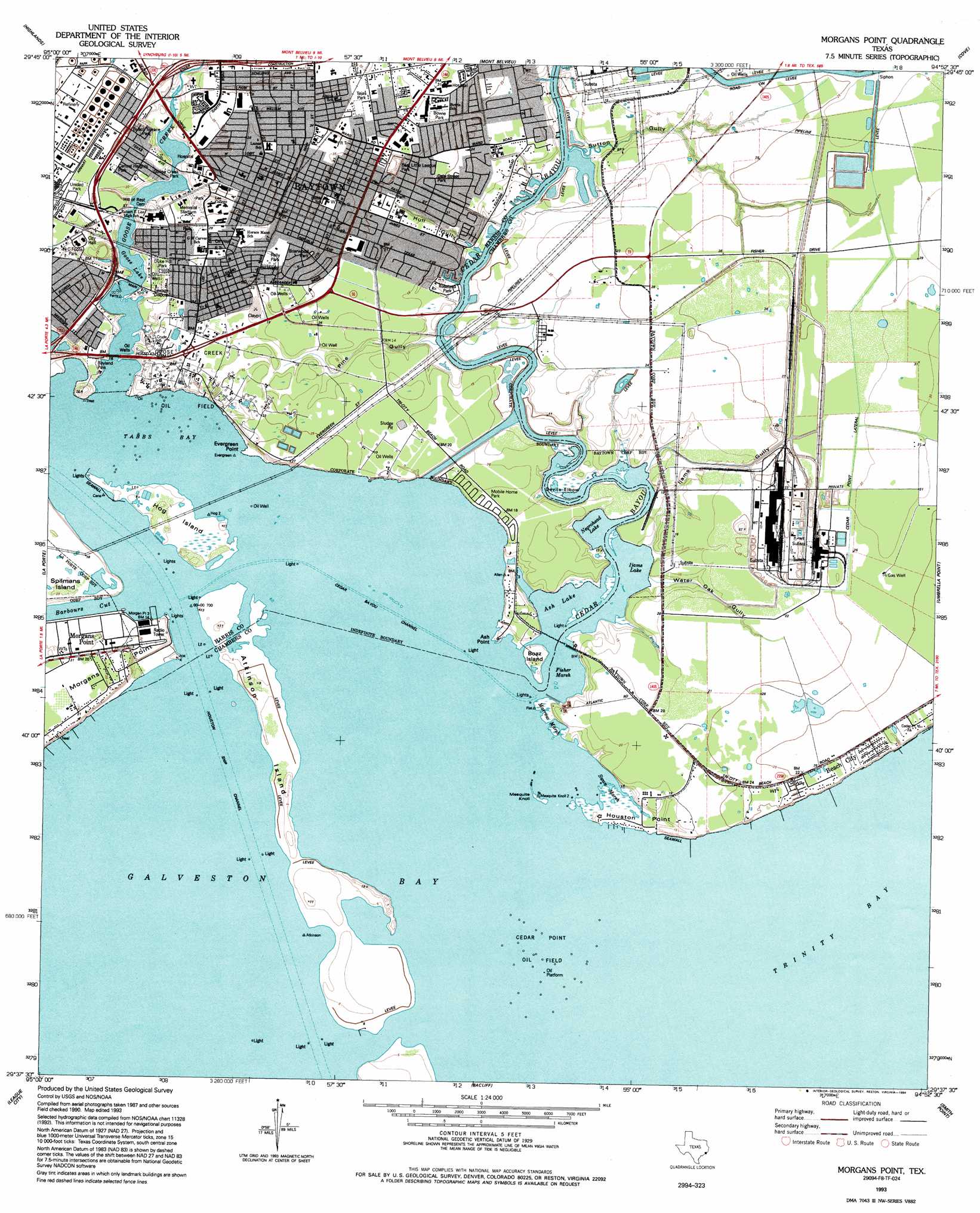
USGS Topo Quad 29094f8 - 1:24,000 scale
| Topo Map Name: | Morgan Point |
| USGS Topo Quad ID: | 29094f8 |
| Print Size: | ca. 21 1/4" wide x 27" high |
| Southeast Coordinates: | 29.625° N latitude / 94.875° W longitude |
| Map Center Coordinates: | 29.6875° N latitude / 94.9375° W longitude |
| U.S. State: | TX |
| Filename: | o29094f8.jpg |
| Download Map JPG Image: | Morgan Point topo map 1:24,000 scale |
| Map Type: | Topographic |
| Topo Series: | 7.5´ |
| Map Scale: | 1:24,000 |
| Source of Map Images: | United States Geological Survey (USGS) |
| Alternate Map Versions: |
Morgan Point TX 1916 Download PDF Buy paper map Morgan Point TX 1956, updated 1957 Download PDF Buy paper map Morgan Point TX 1956, updated 1970 Download PDF Buy paper map Morgans Point TX 1956, updated 1977 Download PDF Buy paper map Morgans Point TX 1982, updated 1982 Download PDF Buy paper map Morgans Point TX 1993, updated 1994 Download PDF Buy paper map Morgans Point TX 1995, updated 1999 Download PDF Buy paper map Morgans Point TX 2010 Download PDF Buy paper map Morgans Point TX 2013 Download PDF Buy paper map Morgans Point TX 2016 Download PDF Buy paper map |
1:24,000 Topo Quads surrounding Morgan Point
Harmaston |
Crosby |
Sheeks |
Moss Bluff |
Shiloh |
Jacinto City |
Highlands |
Mont Belvieu |
Cove |
Anahuac |
Pasadena |
La Porte |
Morgan Point |
Umbrella Point |
Oak Island |
Friendswood |
League City |
Bacliff |
Smith Point |
Lake Stephenson |
Algoa |
Dickinson |
Texas City |
Port Bolivar |
Flake |
> Back to 29094e1 at 1:100,000 scale
> Back to 29094a1 at 1:250,000 scale
> Back to U.S. Topo Maps home
Morgan Point topo map: Gazetteer
Morgan Point: Airports
San Jacinto Methodist Hospital Heliport elevation 6m 19′Morgan Point: Bars
Dow Reef elevation 0m 0′Morgan Point: Bays
Tabbs Bay elevation 0m 0′Morgan Point: Bends
Devils Elbow elevation 0m 0′Morgan Point: Capes
Ash Point elevation 5m 16′Evergreen Point elevation 0m 0′
Houston Point elevation 1m 3′
Morgans Point elevation 5m 16′
Shell Point elevation 0m 0′
Morgan Point: Channels
Barbours Cut elevation 0m 0′Cedar Bayou Channel elevation 0m 0′
Houston Ship Channel elevation 0m 0′
Houston/Galveston Navigation Channel elevation 0m 0′
Morgan Point: Islands
Atkinson Island elevation 0m 0′Hog Island elevation 2m 6′
Morgan Point: Lakes
Ash Lake elevation 0m 0′Ijams Lake elevation 0m 0′
Negrohead Lake elevation 0m 0′
Morgan Point: Oilfields
Cedar Point Oil Field elevation 0m 0′Goose Creek Oil Field elevation 4m 13′
Jergins Oil Field elevation 7m 22′
Morgan Point: Parks
Atkinson Island Wildlife Management Area elevation 2m 6′Baytown Memorial Stadium elevation 7m 22′
N C Foote Park elevation 8m 26′
Pelly Park elevation 10m 32′
Robert Lee High School Baseball Field elevation 6m 19′
Roseland Park elevation 1m 3′
Tejas Park elevation 10m 32′
Morgan Point: Populated Places
Baytown elevation 8m 26′Beach City elevation 6m 19′
Morgans Point elevation 6m 19′
Pelly elevation 9m 29′
Roseland Manor elevation 6m 19′
Morgan Point: Streams
Cedar Bayou elevation 0m 0′Goose Creek elevation 1m 3′
San Jacinto River elevation 0m 0′
Morgan Point: Summits
Mesquite Knoll elevation 0m 0′Morgan Point: Swamps
Fisher Marsh elevation 0m 0′Marrow Marsh elevation 0m 0′
Swan Marsh elevation 0m 0′
Morgan Point: Valleys
Hull Gully elevation 0m 0′Ijams Gully elevation 0m 0′
Pine Gully elevation 0m 0′
Sutton Gully elevation 0m 0′
Water Oak Gully elevation 1m 3′
Morgan Point digital topo map on disk
Buy this Morgan Point topo map showing relief, roads, GPS coordinates and other geographical features, as a high-resolution digital map file on DVD: