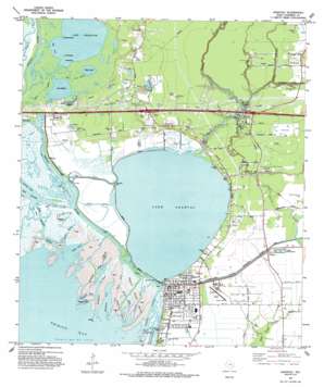
Anahuac Topo Map Texas
To zoom in, hover over the map of Anahuac
USGS Topo Quad 29094g6 - 1:24,000 scale
| Topo Map Name: | Anahuac |
| USGS Topo Quad ID: | 29094g6 |
| Print Size: | ca. 21 1/4" wide x 27" high |
| Southeast Coordinates: | 29.75° N latitude / 94.625° W longitude |
| Map Center Coordinates: | 29.8125° N latitude / 94.6875° W longitude |
| U.S. State: | TX |
| Filename: | o29094g6.jpg |
| Download Map JPG Image: | Anahuac topo map 1:24,000 scale |
| Map Type: | Topographic |
| Topo Series: | 7.5´ |
| Map Scale: | 1:24,000 |
| Source of Map Images: | United States Geological Survey (USGS) |
| Alternate Map Versions: |
Anahuac TX 1942, updated 1958 Download PDF Buy paper map Anahuac TX 1961, updated 1964 Download PDF Buy paper map Anahuac TX 1961, updated 1973 Download PDF Buy paper map Anahuac TX 1961, updated 1978 Download PDF Buy paper map Anahuac TX 1993, updated 1993 Download PDF Buy paper map Anahuac TX 2010 Download PDF Buy paper map Anahuac TX 2013 Download PDF Buy paper map Anahuac TX 2016 Download PDF Buy paper map |
1:24,000 Topo Quads surrounding Anahuac
> Back to 29094e1 at 1:100,000 scale
> Back to 29094a1 at 1:250,000 scale
> Back to U.S. Topo Maps home
Anahuac topo map: Gazetteer
Anahuac: Airports
Chambers County Airport elevation 6m 19′CIG 816 Heliport elevation 6m 19′
Anahuac: Bays
Barrow Slough elevation 6m 19′Bulkhead Cove elevation 0m 0′
Garden Bayou elevation 0m 0′
Jacks elevation 0m 0′
Wes Cove elevation 0m 0′
Anahuac: Capes
Buzzard Roost elevation -1m -4′Sand Point elevation 0m 0′
Anahuac: Channels
Barge Bayou elevation 2m 6′Browns Pass elevation 0m 0′
Jacks Pass elevation 0m 0′
Kings Pass elevation 0m 0′
Lake Pass elevation 1m 3′
Lighthouse Pass elevation 0m 0′
Little Triangle Pass elevation 1m 3′
Long Island Bayou elevation 0m 0′
Old River Cutoff elevation 0m 0′
Old River Pass elevation 0m 0′
Southwest Pass elevation 0m 0′
Triangle Pass elevation 0m 0′
Turtle Bay Pass elevation 2m 6′
Anahuac: Guts
Big Hog Bayou elevation 1m 3′Blind Bayou elevation 0m 0′
John Wiggins Bayou elevation 1m 3′
Little Hog Bayou elevation 2m 6′
Mud Lake Bayou elevation 1m 3′
Smith Bayou elevation 0m 0′
Anahuac: Islands
Bird Island elevation 0m 0′Buckeye Island elevation 0m 0′
Anahuac: Lakes
Lake Anahuac elevation 2m 6′Lake Charlotte elevation 0m 0′
Lake Miller elevation -1m -4′
Mud Lake elevation 1m 3′
Peterson Lake elevation 0m 0′
Anahuac: Oilfields
Turtle Bay Oil Field elevation 7m 22′Anahuac: Parks
Fort Anahuac Park elevation 6m 19′Anahuac: Populated Places
Anahuac elevation 9m 29′Eminence elevation 9m 29′
Hankamer elevation 10m 32′
Turtle Bayou elevation 9m 29′
Wallisville elevation 2m 6′
Anahuac: Reservoirs
Wallisville Lake elevation 6m 19′Anahuac: Streams
Cow Island Bayou elevation 3m 9′Old River elevation 0m 0′
Spring Branch elevation 1m 3′
Turtle Bayou elevation 2m 6′
Whites Bayou elevation 3m 9′
Anahuac: Valleys
Lee Gully elevation 1m 3′Anahuac digital topo map on disk
Buy this Anahuac topo map showing relief, roads, GPS coordinates and other geographical features, as a high-resolution digital map file on DVD:


