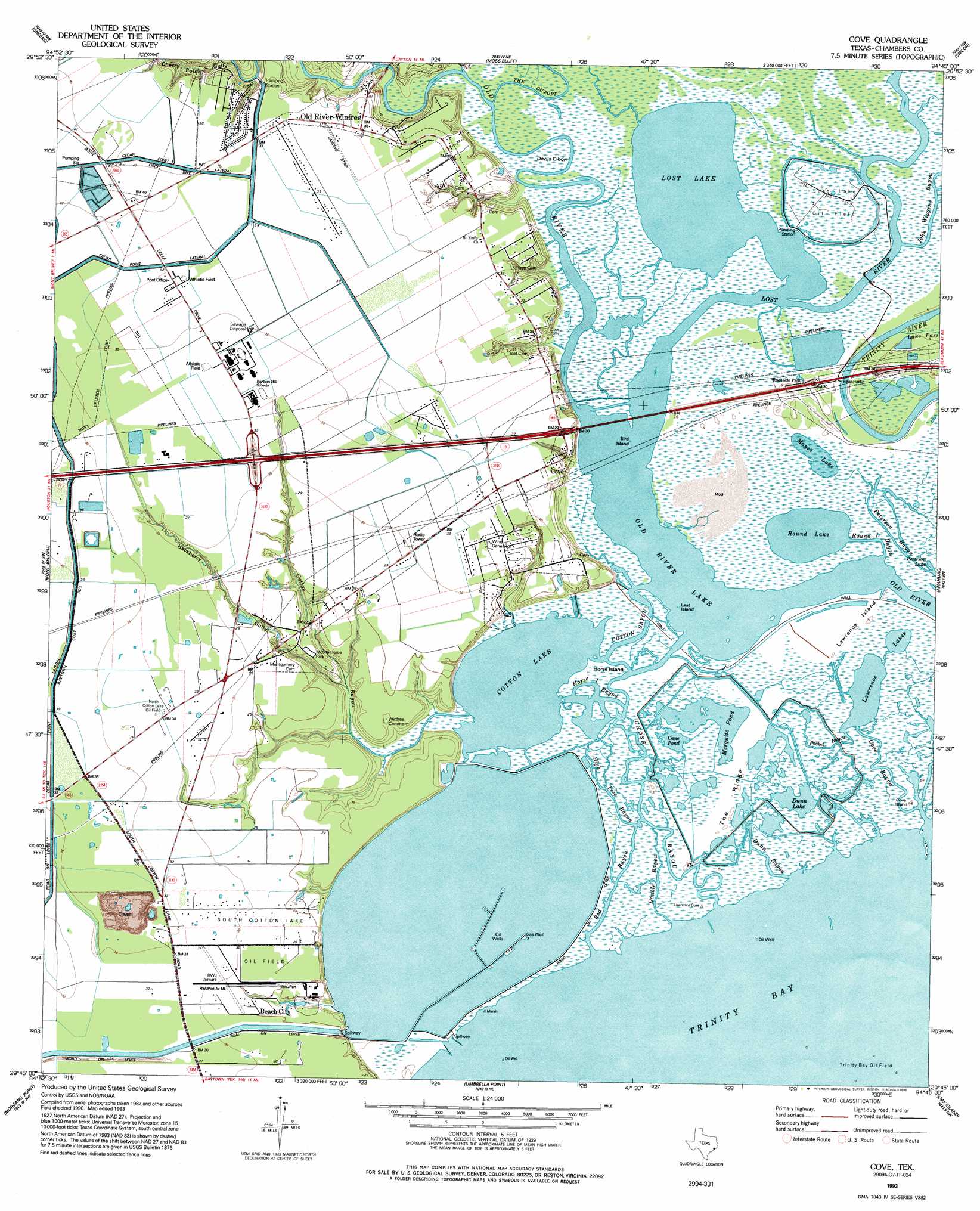
Cove Topo Map Texas
To zoom in, hover over the map of Cove
USGS Topo Quad 29094g7 - 1:24,000 scale
| Topo Map Name: | Cove |
| USGS Topo Quad ID: | 29094g7 |
| Print Size: | ca. 21 1/4" wide x 27" high |
| Southeast Coordinates: | 29.75° N latitude / 94.75° W longitude |
| Map Center Coordinates: | 29.8125° N latitude / 94.8125° W longitude |
| U.S. State: | TX |
| Filename: | o29094g7.jpg |
| Download Map JPG Image: | Cove topo map 1:24,000 scale |
| Map Type: | Topographic |
| Topo Series: | 7.5´ |
| Map Scale: | 1:24,000 |
| Source of Map Images: | United States Geological Survey (USGS) |
| Alternate Map Versions: |
Cove TX 1961, updated 1964 Download PDF Buy paper map Cove TX 1961, updated 1973 Download PDF Buy paper map Cove TX 1961, updated 1977 Download PDF Buy paper map Cove TX 1993, updated 1993 Download PDF Buy paper map Cove TX 1995, updated 2000 Download PDF Buy paper map Cove TX 2010 Download PDF Buy paper map Cove TX 2013 Download PDF Buy paper map Cove TX 2016 Download PDF Buy paper map |
1:24,000 Topo Quads surrounding Cove
Huffman |
Dayton |
Liberty |
Daisetta |
Devers |
Crosby |
Sheeks |
Moss Bluff |
Shiloh |
Whites Bayou |
Highlands |
Mont Belvieu |
Cove |
Anahuac |
Monroe City |
La Porte |
Morgan Point |
Umbrella Point |
Oak Island |
Oyster Bayou |
League City |
Bacliff |
Smith Point |
Lake Stephenson |
Frozen Point |
> Back to 29094e1 at 1:100,000 scale
> Back to 29094a1 at 1:250,000 scale
> Back to U.S. Topo Maps home
Cove topo map: Gazetteer
Cove: Airports
R W J Airpark elevation 9m 29′Slack Airport elevation 11m 36′
Cove: Bays
Horse Island Bayou elevation 0m 0′Cove: Bends
Devils Elbow elevation 0m 0′Cove: Channels
Cross Bayou elevation 0m 0′Cove: Crossings
Interchange 800 elevation 9m 29′Cove: Dams
Cedar Bayou Generating Pond Levee elevation 0m 0′Cove: Guts
Alligator Bayou elevation 0m 0′Cove Bayou elevation 0m 0′
Double Bayou elevation 0m 0′
Dunn Bayou elevation 0m 0′
High Tree Bayou elevation 0m 0′
Peterson Bayou elevation 0m 0′
Pocket Bayou elevation 0m 0′
Red Bayou elevation 0m 0′
Round Lake Bayou elevation 0m 0′
Cove: Islands
Bird Island elevation 0m 0′Cove Island elevation 0m 0′
Horse Island elevation 0m 0′
Lawrence Island elevation 0m 0′
Leat Island elevation 0m 0′
Mustang Island elevation 0m 0′
Cove: Lakes
Cane Pond elevation 0m 0′Cotton Lake elevation 0m 0′
Dunn Lake elevation 0m 0′
Dutton Lake elevation 0m 0′
Lawrence Lakes elevation 0m 0′
Lost Lake elevation 0m 0′
Mayes Lake elevation 0m 0′
Mesquite Pond elevation 0m 0′
Old River Lake elevation 0m 0′
Red Lake elevation 0m 0′
Round Lake elevation 0m 0′
Wet Marsh Pond elevation 1m 3′
Cove: Oilfields
Lost Lake Oil Field elevation 0m 0′North Cotton Lake Oil Field elevation 10m 32′
South Cotton Lake Oil Field elevation 9m 29′
Cove: Populated Places
Cove elevation 7m 22′Old River-Winfree elevation 11m 36′
Cove: Reservoirs
Cedar Boyou Generating Station Clng elevation 0m 0′Cove: Ridges
The Ridge elevation 0m 0′Cove: Streams
Cotton Bayou elevation 0m 0′Little Caney Creek elevation 0m 0′
Lost River elevation 0m 0′
Cove: Valleys
Cherry Point Gully elevation 1m 3′Hackberry Gully elevation 1m 3′
Cove digital topo map on disk
Buy this Cove topo map showing relief, roads, GPS coordinates and other geographical features, as a high-resolution digital map file on DVD: