Winnie Nw Topo Map Texas
To zoom in, hover over the map of Winnie Nw
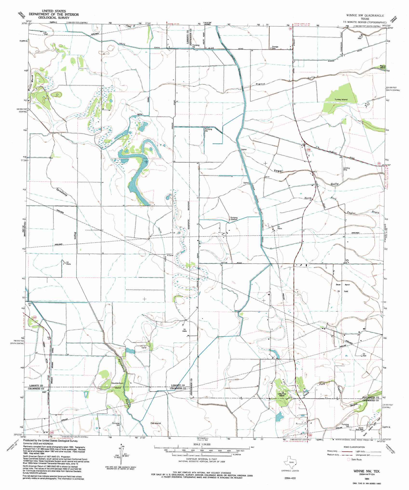
USGS Topo Quad 29094h4 - 1:24,000 scale
| Topo Map Name: | Winnie Nw |
| USGS Topo Quad ID: | 29094h4 |
| Print Size: | ca. 21 1/4" wide x 27" high |
| Southeast Coordinates: | 29.875° N latitude / 94.375° W longitude |
| Map Center Coordinates: | 29.9375° N latitude / 94.4375° W longitude |
| U.S. State: | TX |
| Filename: | o29094h4.jpg |
| Download Map JPG Image: | Winnie Nw topo map 1:24,000 scale |
| Map Type: | Topographic |
| Topo Series: | 7.5´ |
| Map Scale: | 1:24,000 |
| Source of Map Images: | United States Geological Survey (USGS) |
| Alternate Map Versions: |
Winnie NW TX 1962, updated 1964 Download PDF Buy paper map Winnie NW TX 1962, updated 1978 Download PDF Buy paper map Winnie NW TX 1994, updated 1994 Download PDF Buy paper map Winnie NW TX 2010 Download PDF Buy paper map Winnie NW TX 2013 Download PDF Buy paper map Winnie NW TX 2016 Download PDF Buy paper map |
1:24,000 Topo Quads surrounding Winnie Nw
Hardin |
Thorson Gully |
Sour Lake |
Bevil Oaks |
Voth |
Daisetta |
Devers |
Nome |
China |
Beaumont West |
Shiloh |
Whites Bayou |
Winnie Nw |
Fannett West |
Fannett East |
Anahuac |
Monroe City |
Stowell |
Hamshire |
Alligator Hole Marsh |
Oak Island |
Oyster Bayou |
Stanolind Reservoir |
Whites Ranch |
Star Lake |
> Back to 29094e1 at 1:100,000 scale
> Back to 29094a1 at 1:250,000 scale
> Back to U.S. Topo Maps home
Winnie Nw topo map: Gazetteer
Winnie Nw: Airports
Sonny Broussard Landing Strip elevation 11m 36′Winnie Nw: Canals
East Branch Devers Canal elevation 11m 36′Nolte Canal elevation 13m 42′
Winnie Nw: Islands
Double Gum Island elevation 10m 32′Little Pine Island elevation 11m 36′
Oak Island elevation 9m 29′
Turkey Island elevation 9m 29′
Winnie Nw digital topo map on disk
Buy this Winnie Nw topo map showing relief, roads, GPS coordinates and other geographical features, as a high-resolution digital map file on DVD: