Moss Bluff Topo Map Texas
To zoom in, hover over the map of Moss Bluff
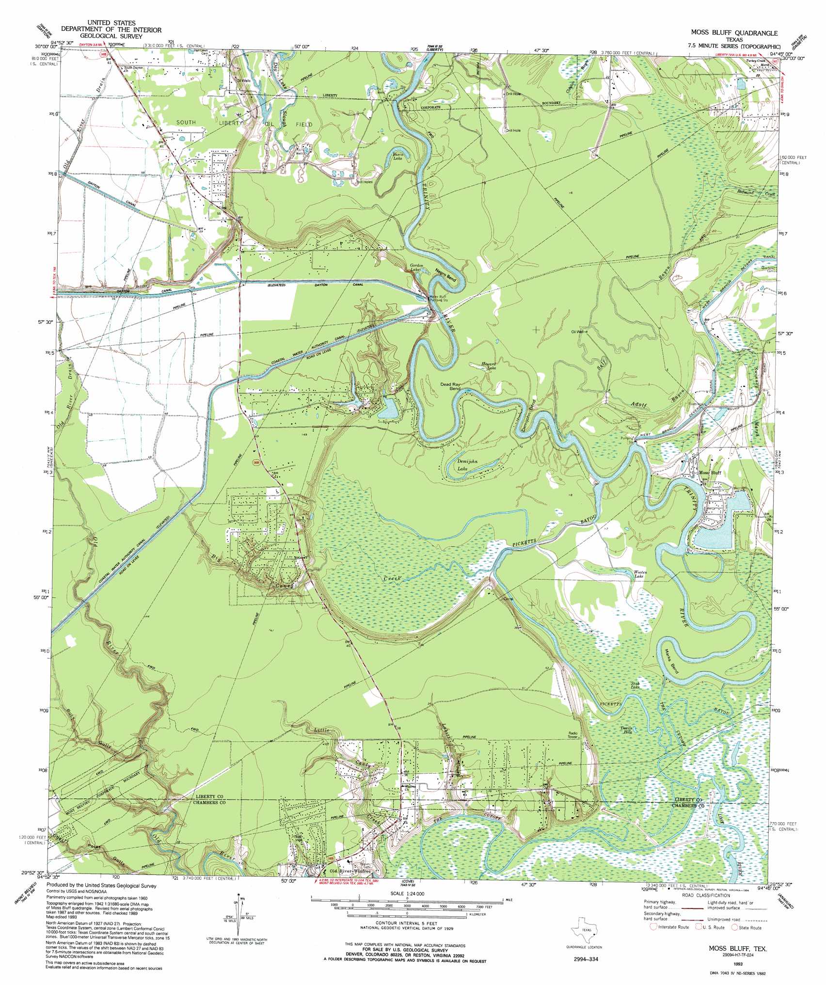
USGS Topo Quad 29094h7 - 1:24,000 scale
| Topo Map Name: | Moss Bluff |
| USGS Topo Quad ID: | 29094h7 |
| Print Size: | ca. 21 1/4" wide x 27" high |
| Southeast Coordinates: | 29.875° N latitude / 94.75° W longitude |
| Map Center Coordinates: | 29.9375° N latitude / 94.8125° W longitude |
| U.S. State: | TX |
| Filename: | o29094h7.jpg |
| Download Map JPG Image: | Moss Bluff topo map 1:24,000 scale |
| Map Type: | Topographic |
| Topo Series: | 7.5´ |
| Map Scale: | 1:24,000 |
| Source of Map Images: | United States Geological Survey (USGS) |
| Alternate Map Versions: |
Moss Bluff TX 1961, updated 1964 Download PDF Buy paper map Moss Bluff TX 1961, updated 1977 Download PDF Buy paper map Moss Bluff TX 1961, updated 1983 Download PDF Buy paper map Moss Bluff TX 1993, updated 1994 Download PDF Buy paper map Moss Bluff TX 2010 Download PDF Buy paper map Moss Bluff TX 2013 Download PDF Buy paper map Moss Bluff TX 2016 Download PDF Buy paper map |
1:24,000 Topo Quads surrounding Moss Bluff
Plum Grove |
Simmons Bottom |
Capers Ridge |
Hardin |
Thorson Gully |
Huffman |
Dayton |
Liberty |
Daisetta |
Devers |
Crosby |
Sheeks |
Moss Bluff |
Shiloh |
Whites Bayou |
Highlands |
Mont Belvieu |
Cove |
Anahuac |
Monroe City |
La Porte |
Morgan Point |
Umbrella Point |
Oak Island |
Oyster Bayou |
> Back to 29094e1 at 1:100,000 scale
> Back to 29094a1 at 1:250,000 scale
> Back to U.S. Topo Maps home
Moss Bluff topo map: Gazetteer
Moss Bluff: Bends
Dead Ray Bend elevation 2m 6′Demijohn Bend elevation 5m 16′
Devils Hole elevation 2m 6′
Marks Bend elevation 2m 6′
Negro Bend elevation 2m 6′
Moss Bluff: Canals
Coastal Water Authority Canal elevation 15m 49′Lynchburg Canal elevation 9m 29′
Moss Bluff: Guts
Day Lake Slough elevation 3m 9′Picketts Bayou elevation 2m 6′
The Cutoff elevation 1m 3′
Moss Bluff: Lakes
Basin Lake elevation 3m 9′Boggy Lake elevation 3m 9′
Demijohn Lake elevation 3m 9′
Duck Lake elevation 3m 9′
Gordon Lake elevation 3m 9′
Howard Lake elevation 3m 9′
Lease Lake elevation 5m 16′
Stub Lake elevation 2m 6′
Talley Lake elevation 15m 49′
Wooten Lake elevation 2m 6′
Moss Bluff: Populated Places
Moss Bluff elevation 5m 16′Old River Community elevation 11m 36′
South Dayton elevation 18m 59′
Timber Lake Estates elevation 15m 49′
Moss Bluff: Reservoirs
Timber Lake elevation 4m 13′Moss Bluff: Springs
Moss Spring elevation 2m 6′Moss Bluff: Streams
Adolph Bayou elevation 2m 6′Big Caney Creek elevation 2m 6′
Labitt Creek elevation 1m 3′
Redmond Creek elevation 2m 6′
Self Bayou elevation 1m 3′
The Cut Off elevation 3m 9′
Moss Bluff: Valleys
Buck Gully elevation 1m 3′Moss Bluff digital topo map on disk
Buy this Moss Bluff topo map showing relief, roads, GPS coordinates and other geographical features, as a high-resolution digital map file on DVD: