East Columbia Topo Map Texas
To zoom in, hover over the map of East Columbia
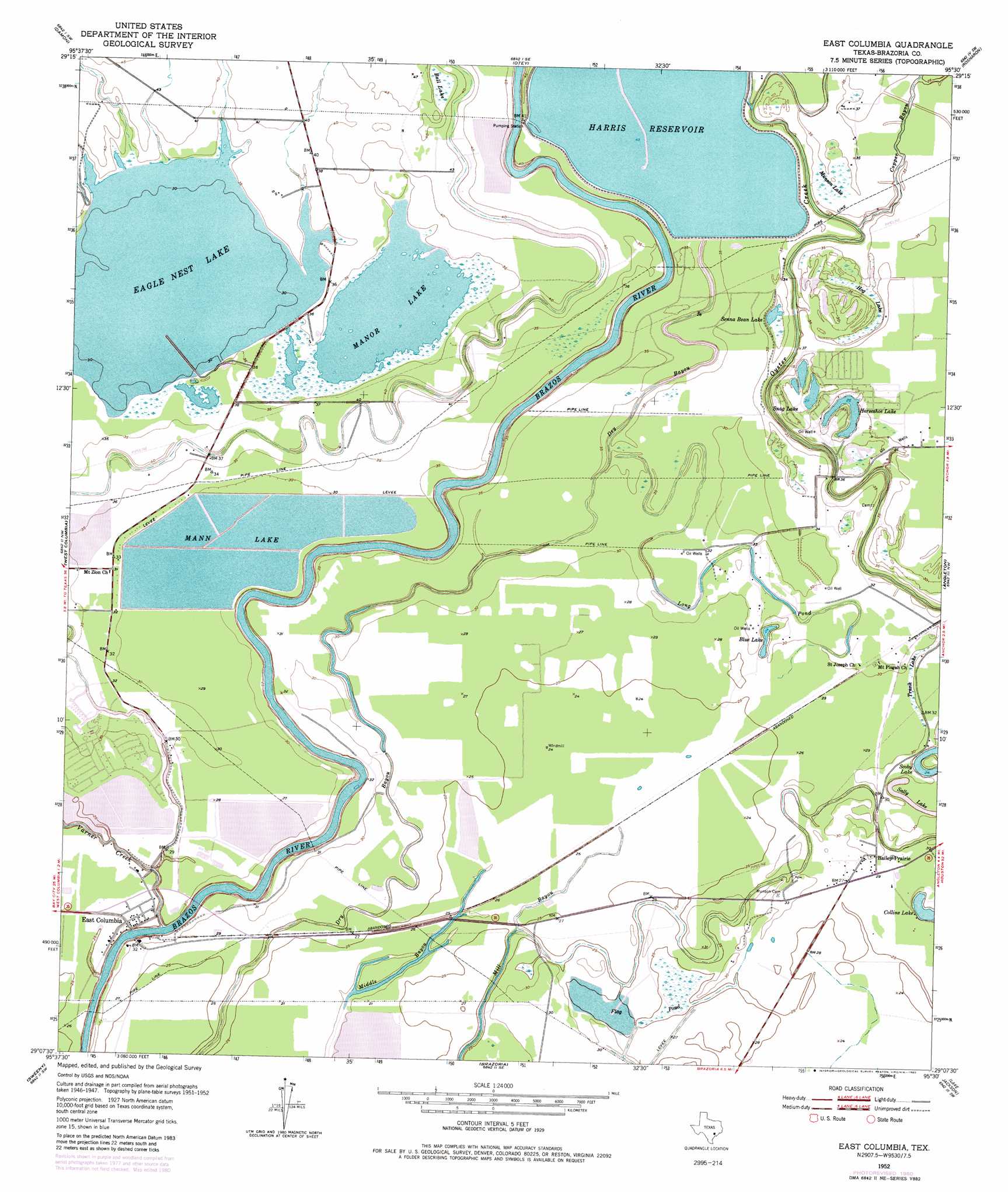
USGS Topo Quad 29095b5 - 1:24,000 scale
| Topo Map Name: | East Columbia |
| USGS Topo Quad ID: | 29095b5 |
| Print Size: | ca. 21 1/4" wide x 27" high |
| Southeast Coordinates: | 29.125° N latitude / 95.5° W longitude |
| Map Center Coordinates: | 29.1875° N latitude / 95.5625° W longitude |
| U.S. State: | TX |
| Filename: | o29095b5.jpg |
| Download Map JPG Image: | East Columbia topo map 1:24,000 scale |
| Map Type: | Topographic |
| Topo Series: | 7.5´ |
| Map Scale: | 1:24,000 |
| Source of Map Images: | United States Geological Survey (USGS) |
| Alternate Map Versions: |
East Columbia TX 1952, updated 1953 Download PDF Buy paper map East Columbia TX 1952, updated 1969 Download PDF Buy paper map East Columbia TX 1952, updated 1980 Download PDF Buy paper map East Columbia TX 2010 Download PDF Buy paper map East Columbia TX 2013 Download PDF Buy paper map East Columbia TX 2016 Download PDF Buy paper map |
1:24,000 Topo Quads surrounding East Columbia
Needville |
Smithers Lake |
Thompsons |
Juliff |
Manvel |
Guy |
Damon |
Otey |
Rosharon |
Liverpool |
Danciger |
West Columbia |
East Columbia |
Angleton |
Danbury |
Ashwood |
Sweeny |
Brazoria |
Lake Jackson |
Oyster Creek |
Bay City Ne |
Cedar Lane |
Cedar Lane Ne |
Jones Creek |
Freeport |
> Back to 29095a1 at 1:100,000 scale
> Back to 29094a1 at 1:250,000 scale
> Back to U.S. Topo Maps home
East Columbia topo map: Gazetteer
East Columbia: Airports
Columbia Lakes Heliport elevation 9m 29′East Columbia: Dams
Bar X Ranch Lake Levee elevation 8m 26′Beal Reservoir Levee elevation 9m 29′
Bintliff Lake Levee elevation 7m 22′
Black Ranch Lake Levee elevation 12m 39′
Griffith Reservoir Levee elevation 7m 22′
Lagoon Reservoir Dam elevation 8m 26′
Mann Lake Dam elevation 8m 26′
Tenneco Lake Number 1 Levee elevation 8m 26′
Tenneco Lake Number 2 Levee elevation 4m 13′
William Harris Reservoir Dam elevation 5m 16′
East Columbia: Lakes
Blue Lake elevation 7m 22′Collins Lake elevation 7m 22′
Eagle Nest Lake elevation 8m 26′
Horseshoe Lake elevation 8m 26′
Long Pond elevation 9m 29′
Manor Lake elevation 10m 32′
Sally Lake elevation 8m 26′
Scoby Lake elevation 7m 22′
Senna Bean Lake elevation 8m 26′
Snag Lake elevation 9m 29′
Trunk Lake elevation 9m 29′
East Columbia: Populated Places
Bailey Prairie elevation 9m 29′East Columbia elevation 9m 29′
Holiday Lakes elevation 11m 36′
East Columbia: Reservoirs
Bar X Ranch Lake elevation 8m 26′Beal Reservoir elevation 9m 29′
Bintliff Lake elevation 7m 22′
Black Ranch Lake elevation 12m 39′
Griffith Reservoir elevation 7m 22′
Harris Reservoir elevation 13m 42′
Lagoon Reservoir elevation 8m 26′
Mann Lake elevation 9m 29′
Tenneco Lake Number 1 elevation 8m 26′
Tenneco Lake Number 2 elevation 4m 13′
William Harris Reservoir elevation 5m 16′
East Columbia: Streams
Copper Bayou elevation 9m 29′Varner Creek elevation 1m 3′
East Columbia: Swamps
Bell Lake elevation 14m 45′Flag Pond elevation 8m 26′
Hog Lake elevation 8m 26′
Munson Lake elevation 10m 32′
East Columbia digital topo map on disk
Buy this East Columbia topo map showing relief, roads, GPS coordinates and other geographical features, as a high-resolution digital map file on DVD: