Rosharon Topo Map Texas
To zoom in, hover over the map of Rosharon
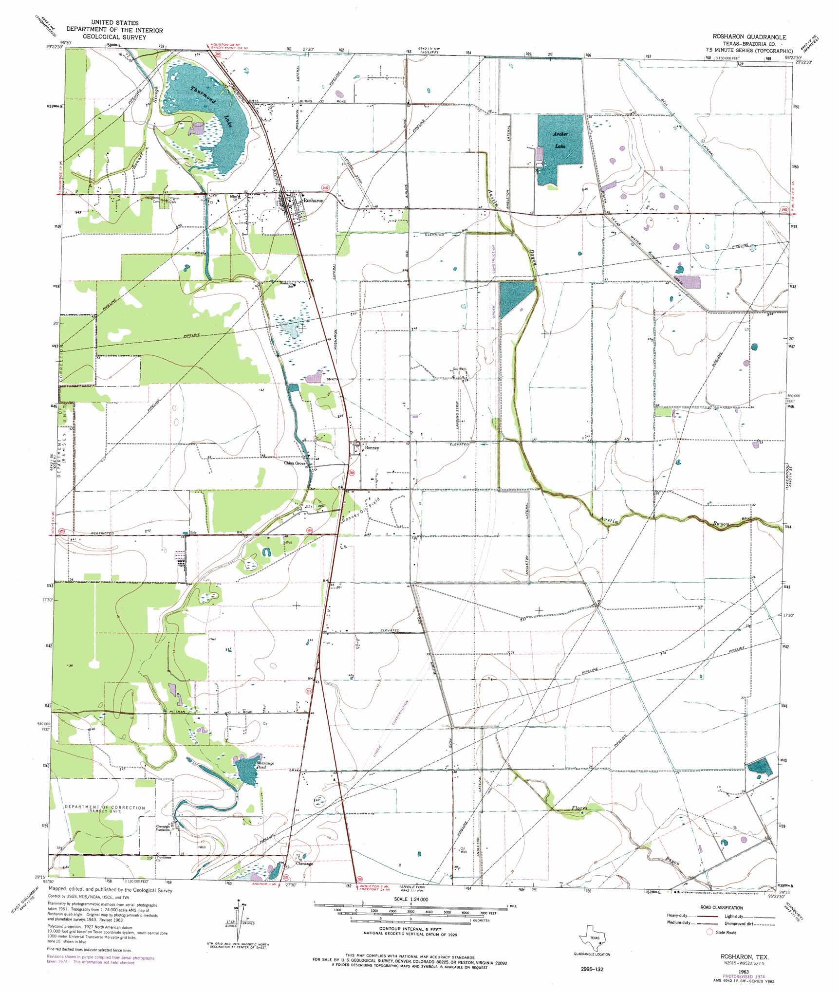
USGS Topo Quad 29095c4 - 1:24,000 scale
| Topo Map Name: | Rosharon |
| USGS Topo Quad ID: | 29095c4 |
| Print Size: | ca. 21 1/4" wide x 27" high |
| Southeast Coordinates: | 29.25° N latitude / 95.375° W longitude |
| Map Center Coordinates: | 29.3125° N latitude / 95.4375° W longitude |
| U.S. State: | TX |
| Filename: | o29095c4.jpg |
| Download Map JPG Image: | Rosharon topo map 1:24,000 scale |
| Map Type: | Topographic |
| Topo Series: | 7.5´ |
| Map Scale: | 1:24,000 |
| Source of Map Images: | United States Geological Survey (USGS) |
| Alternate Map Versions: |
Rosharon TX 1943, updated 1959 Download PDF Buy paper map Rosharon TX 1963, updated 1966 Download PDF Buy paper map Rosharon TX 1963, updated 1977 Download PDF Buy paper map Rosharon TX 2010 Download PDF Buy paper map Rosharon TX 2013 Download PDF Buy paper map Rosharon TX 2016 Download PDF Buy paper map |
1:24,000 Topo Quads surrounding Rosharon
Sugar Land |
Missouri City |
Almeda |
Pearland |
Friendswood |
Smithers Lake |
Thompsons |
Juliff |
Manvel |
Algoa |
Damon |
Otey |
Rosharon |
Liverpool |
Mustang Bayou |
West Columbia |
East Columbia |
Angleton |
Danbury |
Hoskins Mound |
Sweeny |
Brazoria |
Lake Jackson |
Oyster Creek |
Christmas Point |
> Back to 29095a1 at 1:100,000 scale
> Back to 29094a1 at 1:250,000 scale
> Back to U.S. Topo Maps home
Rosharon topo map: Gazetteer
Rosharon: Airports
Custom Aire Service Airport elevation 9m 29′Riceland Flying Service Airport elevation 15m 49′
Rosharon: Canals
Rosharon Lateral elevation 16m 52′Rosharon Lateral elevation 14m 45′
Rosharon: Dams
Archer Lake Levee elevation 14m 45′Division Lake Levee elevation 12m 39′
Rosharon: Guts
Bonner Slough elevation 15m 49′Rosharon: Lakes
Archer Lake elevation 14m 45′Chenango Pond elevation 12m 39′
Thurmond Lake elevation 15m 49′
Rosharon: Oilfields
Bonney Oil Field elevation 14m 45′Rosharon: Populated Places
Bonney elevation 14m 45′Chenango elevation 12m 39′
China Grove elevation 14m 45′
Rosharon elevation 15m 49′
Rosharon: Reservoirs
Archer Lake elevation 14m 45′Division Lake elevation 12m 39′
Rosharon digital topo map on disk
Buy this Rosharon topo map showing relief, roads, GPS coordinates and other geographical features, as a high-resolution digital map file on DVD: