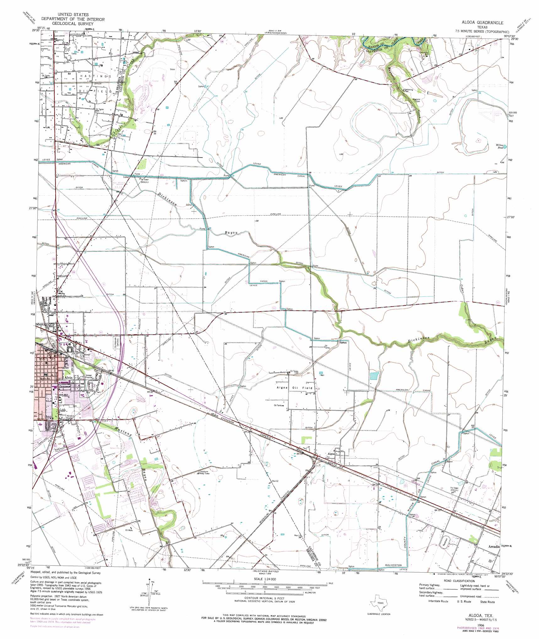
Algoa Topo Map Texas
To zoom in, hover over the map of Algoa
USGS Topo Quad 29095d2 - 1:24,000 scale
| Topo Map Name: | Algoa |
| USGS Topo Quad ID: | 29095d2 |
| Print Size: | ca. 21 1/4" wide x 27" high |
| Southeast Coordinates: | 29.375° N latitude / 95.125° W longitude |
| Map Center Coordinates: | 29.4375° N latitude / 95.1875° W longitude |
| U.S. State: | TX |
| Filename: | o29095d2.jpg |
| Download Map JPG Image: | Algoa topo map 1:24,000 scale |
| Map Type: | Topographic |
| Topo Series: | 7.5´ |
| Map Scale: | 1:24,000 |
| Source of Map Images: | United States Geological Survey (USGS) |
| Alternate Map Versions: |
Algoa TX 1929 Download PDF Buy paper map Algoa TX 1956, updated 1957 Download PDF Buy paper map Algoa TX 1956, updated 1970 Download PDF Buy paper map Algoa TX 1956, updated 1977 Download PDF Buy paper map Algoa TX 1956, updated 1977 Download PDF Buy paper map Algoa TX 2010 Download PDF Buy paper map Algoa TX 2013 Download PDF Buy paper map Algoa TX 2016 Download PDF Buy paper map |
1:24,000 Topo Quads surrounding Algoa
Bellaire |
Park Place |
Pasadena |
La Porte |
Morgan Point |
Almeda |
Pearland |
Friendswood |
League City |
Bacliff |
Juliff |
Manvel |
Algoa |
Dickinson |
Texas City |
Rosharon |
Liverpool |
Mustang Bayou |
Hitchcock |
Virginia Point |
Angleton |
Danbury |
Hoskins Mound |
Sea Isle |
Lake Como |
> Back to 29095a1 at 1:100,000 scale
> Back to 29094a1 at 1:250,000 scale
> Back to U.S. Topo Maps home
Algoa topo map: Gazetteer
Algoa: Airports
D W C Heliport elevation 12m 39′Golden Pegasus Ranch Heliport elevation 9m 29′
Kami-Kazi Airport elevation 8m 26′
Algoa: Canals
American Canal elevation 12m 39′Algoa: Lakes
Willow Pond elevation 8m 26′Algoa: Oilfields
Algoa Oil Field elevation 9m 29′Hastings Oil Field elevation 16m 52′
Algoa: Parks
Bay Area Christian School Baseball Field elevation 8m 26′Bay Area Christian School Football Field elevation 9m 29′
Creekside Intermediate School Football Field elevation 8m 26′
Algoa: Populated Places
Algoa elevation 10m 32′Alvin elevation 14m 45′
Carmel Village elevation 11m 36′
Century Oaks Estates elevation 8m 26′
Crescent Ranch Estates elevation 9m 29′
Eagle Lakes elevation 9m 29′
El Dorado elevation 11m 36′
Falcon Ridge elevation 9m 29′
Mission Estates elevation 10m 32′
Rancho Viejo elevation 10m 32′
San Joaquin Estates elevation 11m 36′
Sun Meadow elevation 11m 36′
Windsong elevation 11m 36′
Windsor Estates elevation 11m 36′
Algoa: Streams
Cedar Creek elevation 1m 3′Magnolia Creek elevation 1m 3′
Algoa digital topo map on disk
Buy this Algoa topo map showing relief, roads, GPS coordinates and other geographical features, as a high-resolution digital map file on DVD: