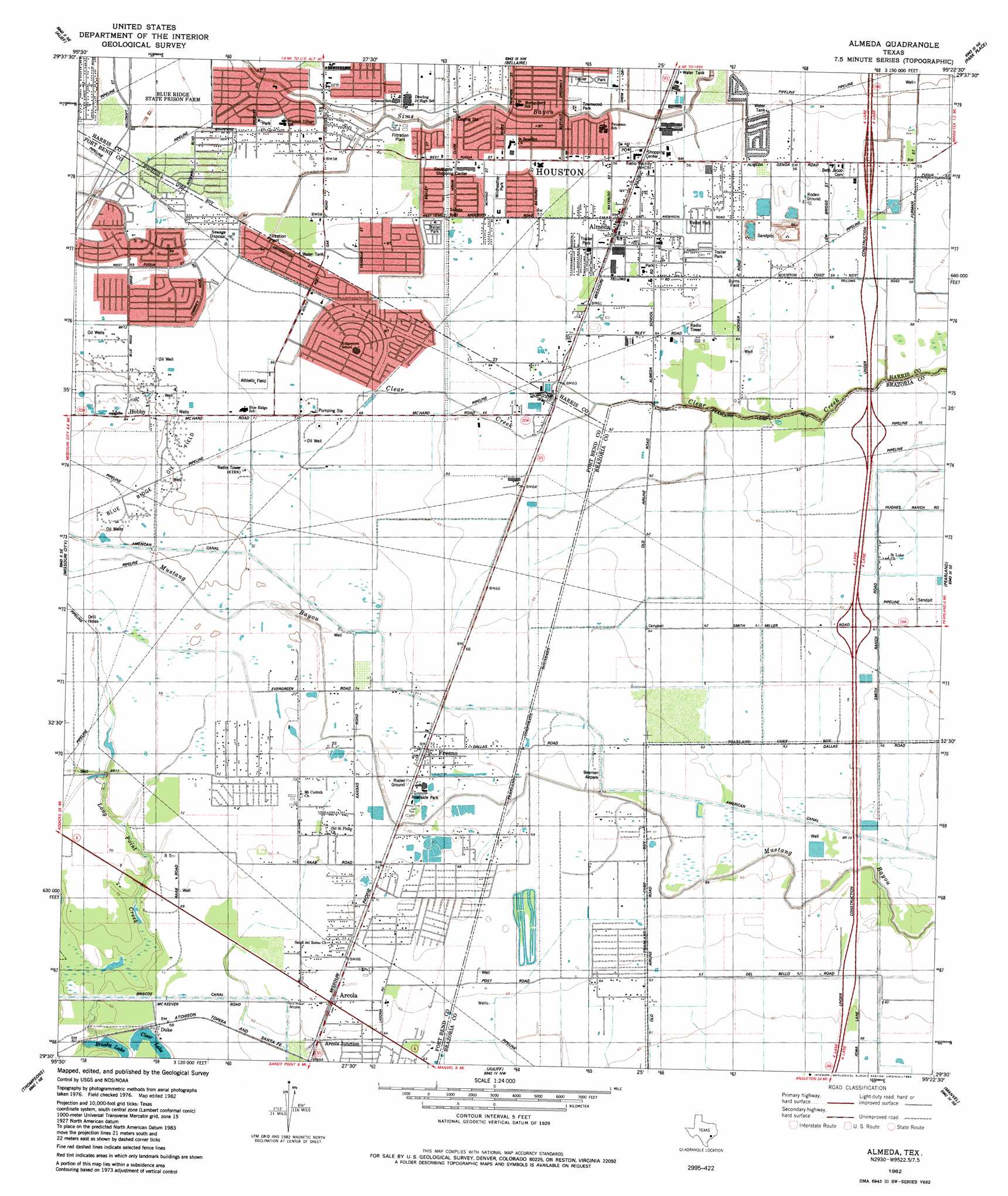
Almeda Topo Map Texas
To zoom in, hover over the map of Almeda
USGS Topo Quad 29095e4 - 1:24,000 scale
| Topo Map Name: | Almeda |
| USGS Topo Quad ID: | 29095e4 |
| Print Size: | ca. 21 1/4" wide x 27" high |
| Southeast Coordinates: | 29.5° N latitude / 95.375° W longitude |
| Map Center Coordinates: | 29.5625° N latitude / 95.4375° W longitude |
| U.S. State: | TX |
| Filename: | o29095e4.jpg |
| Download Map JPG Image: | Almeda topo map 1:24,000 scale |
| Map Type: | Topographic |
| Topo Series: | 7.5´ |
| Map Scale: | 1:24,000 |
| Source of Map Images: | United States Geological Survey (USGS) |
| Alternate Map Versions: |
Almeda TX 1915 Download PDF Buy paper map Almeda TX 1915 Download PDF Buy paper map Almeda TX 1955, updated 1957 Download PDF Buy paper map Almeda TX 1955, updated 1970 Download PDF Buy paper map Almeda TX 1955, updated 1970 Download PDF Buy paper map Almeda TX 1982, updated 1983 Download PDF Buy paper map Almeda TX 1995, updated 1999 Download PDF Buy paper map Almeda TX 2010 Download PDF Buy paper map Almeda TX 2013 Download PDF Buy paper map Almeda TX 2016 Download PDF Buy paper map |
1:24,000 Topo Quads surrounding Almeda
Addicks |
Hedwig Village |
Houston Heights |
Settegast |
Jacinto City |
Clodine |
Alief |
Bellaire |
Park Place |
Pasadena |
Sugar Land |
Missouri City |
Almeda |
Pearland |
Friendswood |
Smithers Lake |
Thompsons |
Juliff |
Manvel |
Algoa |
Damon |
Otey |
Rosharon |
Liverpool |
Mustang Bayou |
> Back to 29095e1 at 1:100,000 scale
> Back to 29094a1 at 1:250,000 scale
> Back to U.S. Topo Maps home
Almeda topo map: Gazetteer
Almeda: Airports
Beaman Airpark elevation 21m 68′Houston-Southwest Airport elevation 20m 65′
Life Flight/Refuel Heliport elevation 20m 65′
Almeda: Lakes
Clear Lake elevation 16m 52′Almeda: Oilfields
Blue Ridge Oil Field elevation 22m 72′Almeda: Parks
Almeda Park elevation 19m 62′Canterbury Park elevation 17m 55′
Townwood Park elevation 15m 49′
Wildheather Park elevation 18m 59′
Willowridge High School Baseball Field elevation 21m 68′
Willowridge High School Football Field elevation 22m 72′
Willowridge High School Softball Field elevation 21m 68′
Windsor Village Park elevation 18m 59′
Almeda: Populated Places
Almeda elevation 18m 59′Almeda Manor elevation 16m 52′
Arcola Junction elevation 20m 65′
Briar Vista elevation 21m 68′
Briarvilla elevation 20m 65′
Canterbury Village elevation 17m 55′
Duke elevation 20m 65′
Dunbarton Oaks elevation 17m 55′
Fresno elevation 22m 72′
Hobby elevation 23m 75′
Meredeth Manor elevation 17m 55′
Monarch Estates elevation 17m 55′
Palmetto elevation 22m 72′
Post Oak Village elevation 18m 59′
Ridgegate elevation 20m 65′
Ridgemont elevation 20m 65′
South Main Plaza elevation 20m 65′
Tiffany Gardens elevation 17m 55′
Waterbury elevation 20m 65′
Westbrook elevation 18m 59′
Westhampton elevation 16m 52′
Wildheather elevation 18m 59′
Winchester elevation 18m 59′
Almeda: Streams
Long Point Creek elevation 17m 55′Almeda: Trails
Almeda Elementary SPARK Park Trail elevation 19m 62′Grissom Elementary SPARK Park Trail elevation 17m 55′
Montgomery Elementary SPARK Park Trail elevation 17m 55′
Petersen Elementary SPARK Park Trail elevation 16m 52′
Almeda digital topo map on disk
Buy this Almeda topo map showing relief, roads, GPS coordinates and other geographical features, as a high-resolution digital map file on DVD: