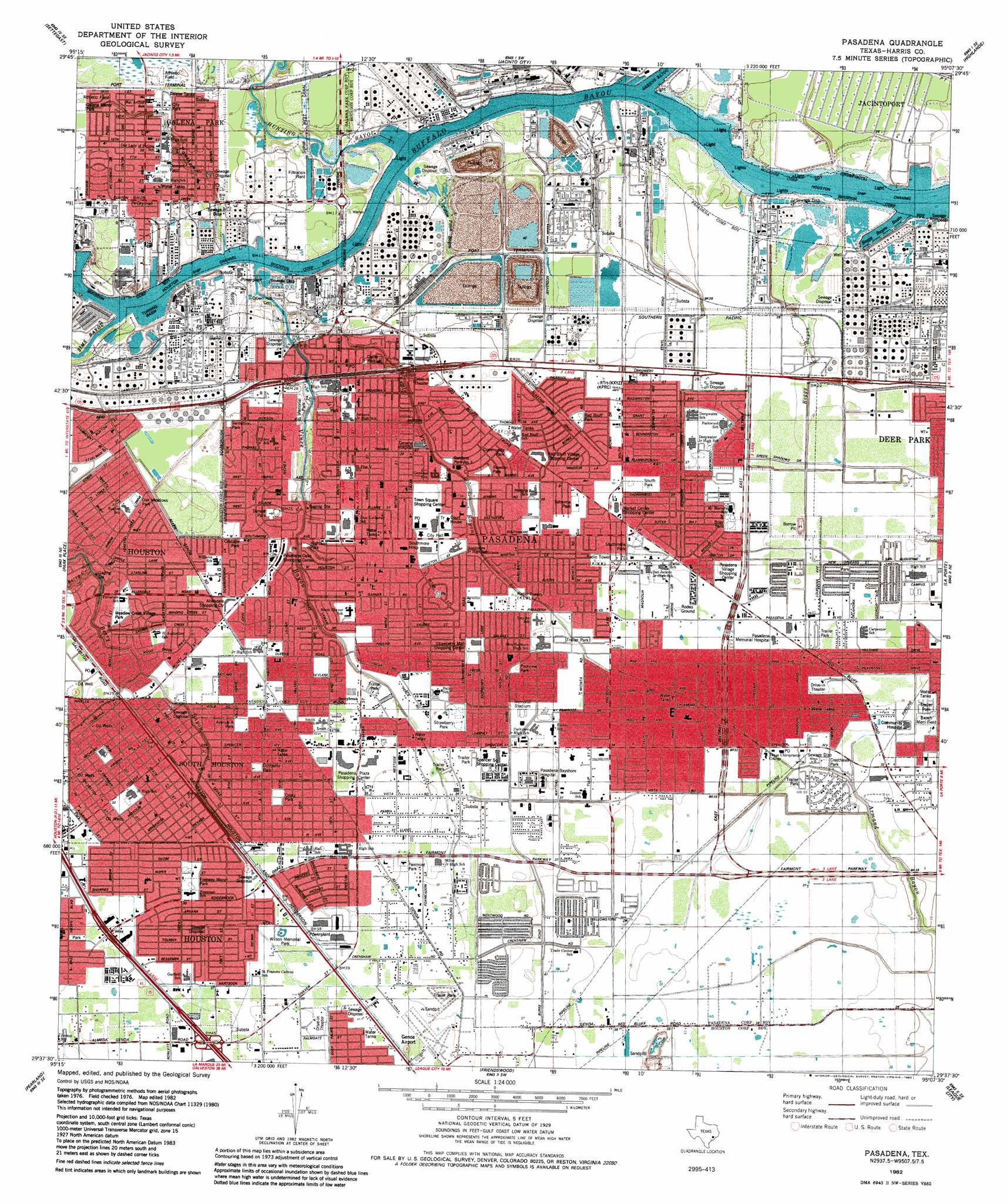
Pasadena Topo Map Texas
To zoom in, hover over the map of Pasadena
USGS Topo Quad 29095f2 - 1:24,000 scale
| Topo Map Name: | Pasadena |
| USGS Topo Quad ID: | 29095f2 |
| Print Size: | ca. 21 1/4" wide x 27" high |
| Southeast Coordinates: | 29.625° N latitude / 95.125° W longitude |
| Map Center Coordinates: | 29.6875° N latitude / 95.1875° W longitude |
| U.S. State: | TX |
| Filename: | o29095f2.jpg |
| Download Map JPG Image: | Pasadena topo map 1:24,000 scale |
| Map Type: | Topographic |
| Topo Series: | 7.5´ |
| Map Scale: | 1:24,000 |
| Source of Map Images: | United States Geological Survey (USGS) |
| Alternate Map Versions: |
Deepwater TX 1915 Download PDF Buy paper map Pasadena TX 1955, updated 1957 Download PDF Buy paper map Pasadena TX 1967, updated 1970 Download PDF Buy paper map Pasadena TX 1982, updated 1983 Download PDF Buy paper map Pasadena TX 1995, updated 2000 Download PDF Buy paper map Pasadena TX 2010 Download PDF Buy paper map Pasadena TX 2013 Download PDF Buy paper map Pasadena TX 2016 Download PDF Buy paper map |
1:24,000 Topo Quads surrounding Pasadena
Aldine |
Humble |
Harmaston |
Crosby |
Sheeks |
Houston Heights |
Settegast |
Jacinto City |
Highlands |
Mont Belvieu |
Bellaire |
Park Place |
Pasadena |
La Porte |
Morgan Point |
Almeda |
Pearland |
Friendswood |
League City |
Bacliff |
Juliff |
Manvel |
Algoa |
Dickinson |
Texas City |
> Back to 29095e1 at 1:100,000 scale
> Back to 29094a1 at 1:250,000 scale
> Back to U.S. Topo Maps home
Pasadena topo map: Gazetteer
Pasadena: Airports
3321 Westside Heliport elevation 11m 36′Bayshore Medical Center Heliport elevation 12m 39′
Diamond Heliport elevation 9m 29′
Ethyl Corporation Heliport elevation 3m 9′
HL and P South Houston Helistop elevation 11m 36′
Pasadena Post Office Heliport elevation 9m 29′
Police Heliport elevation 10m 32′
Southmore Medical Center Heliport elevation 10m 32′
Pasadena: Basins
Boggy Basin elevation 13m 42′Pasadena: Crossings
Interchange 34 elevation 13m 42′Interchange 35 elevation 13m 42′
Pasadena: Parks
Abshire Stadium - Deer Park High School elevation 10m 32′Auxillary Stadium elevation 12m 39′
Bayou Bend Park elevation 9m 29′
City Park elevation 9m 29′
Cristy Park elevation 10m 32′
Cristy Park elevation 10m 32′
Deepwater Park elevation 9m 29′
Dement Stadium elevation 8m 26′
Evalyn Wilson Park elevation 11m 36′
Fairmont Park elevation 11m 36′
Freeway Manor Park elevation 10m 32′
Galena Park City Park elevation 8m 26′
Gardens Park elevation 8m 26′
McGuire Baseball Field elevation 11m 36′
Meadow Creek Park elevation 9m 29′
Meadow Creek Villiage Park elevation 9m 29′
Memorial Park elevation 4m 13′
Oak Meadows Park elevation 9m 29′
Pasadena Independent School District Softball Fields elevation 9m 29′
Pasadena Memorial Stadium elevation 11m 36′
Queens Park elevation 9m 29′
Red Bluff Park elevation 9m 29′
Sam Rayburn High School Football Field elevation 11m 36′
South Houston City Park elevation 10m 32′
Southmore Park elevation 11m 36′
Strawberry Park elevation 11m 36′
Sunset Park elevation 8m 26′
Wilson Memorial Park elevation 12m 39′
Pasadena: Populated Places
Allendale elevation 9m 29′Arlington Heights elevation 11m 36′
Barkgate elevation 12m 39′
Burke Meadow elevation 11m 36′
Easthaven elevation 10m 32′
Freeway Manor elevation 10m 32′
Galena Park elevation 3m 9′
Golden Acres elevation 10m 32′
Gulf Palms elevation 12m 39′
Huntington elevation 10m 32′
Meadow Creek Village elevation 9m 29′
Parkland Village elevation 12m 39′
Parkview Estates elevation 11m 36′
Parkview Manor elevation 11m 36′
Pasadena elevation 9m 29′
Pasadena Gardens elevation 8m 26′
Preston Manor elevation 11m 36′
Preston Villa elevation 10m 32′
Red Bluff elevation 9m 29′
Revlon elevation 9m 29′
South Houston elevation 9m 29′
Stadium Estates elevation 11m 36′
Sun Valley elevation 11m 36′
Tarrytown elevation 11m 36′
Village Grove elevation 10m 32′
Vita Villas elevation 12m 39′
Pasadena: Post Offices
Galnea Park Post Office elevation 11m 36′Pasadena Post Office elevation 10m 32′
South Houston Post Office elevation 9m 29′
Pasadena: Streams
Berry Creek elevation 0m 0′Boggy Bayou elevation 8m 26′
Cotton Patch Bayou elevation 2m 6′
Greens Bayou elevation 0m 0′
Hunting Bayou elevation 0m 0′
Little Vince Bayou elevation 0m 0′
Panther Creek elevation 3m 9′
Sims Bayou elevation 0m 0′
Vince Bayou elevation 0m 0′
Pasadena: Trails
Patterson Elementary SPARK Park Trail elevation 8m 26′Rucker Elementary SPARK Park Trail elevation 9m 29′
Pasadena digital topo map on disk
Buy this Pasadena topo map showing relief, roads, GPS coordinates and other geographical features, as a high-resolution digital map file on DVD: