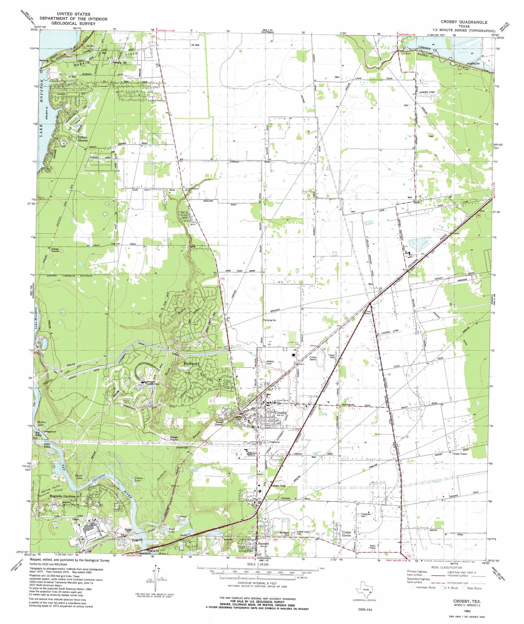
Crosby Topo Map Texas
To zoom in, hover over the map of Crosby
USGS Topo Quad 29095h1 - 1:24,000 scale
| Topo Map Name: | Crosby |
| USGS Topo Quad ID: | 29095h1 |
| Print Size: | ca. 21 1/4" wide x 27" high |
| Southeast Coordinates: | 29.875° N latitude / 95° W longitude |
| Map Center Coordinates: | 29.9375° N latitude / 95.0625° W longitude |
| U.S. State: | TX |
| Filename: | o29095h1.jpg |
| Download Map JPG Image: | Crosby topo map 1:24,000 scale |
| Map Type: | Topographic |
| Topo Series: | 7.5´ |
| Map Scale: | 1:24,000 |
| Source of Map Images: | United States Geological Survey (USGS) |
| Alternate Map Versions: |
Crosby TX 1916 Download PDF Buy paper map Crosby TX 1916 Download PDF Buy paper map Crosby TX 1954, updated 1956 Download PDF Buy paper map Crosby TX 1967, updated 1969 Download PDF Buy paper map Crosby TX 1982, updated 1982 Download PDF Buy paper map Crosby TX 2010 Download PDF Buy paper map Crosby TX 2013 Download PDF Buy paper map Crosby TX 2016 Download PDF Buy paper map |
1:24,000 Topo Quads surrounding Crosby
Outlaw Pond |
Splendora |
Plum Grove |
Simmons Bottom |
Capers Ridge |
Maedan |
Moonshine Hill |
Huffman |
Dayton |
Liberty |
Humble |
Harmaston |
Crosby |
Sheeks |
Moss Bluff |
Settegast |
Jacinto City |
Highlands |
Mont Belvieu |
Cove |
Park Place |
Pasadena |
La Porte |
Morgan Point |
Umbrella Point |
> Back to 29095e1 at 1:100,000 scale
> Back to 29094a1 at 1:250,000 scale
> Back to U.S. Topo Maps home
Crosby topo map: Gazetteer
Crosby: Airports
Flying F Ranch Airport elevation 19m 62′Roeder Airport elevation 14m 45′
Crosby: Canals
Adlong Ditch elevation 16m 52′San Jacinto River Authority Canal elevation 15m 49′
Crosby: Dams
Enderli Reservoir Dam elevation 15m 49′Sludge Fill Pond Levee Number 1 Dam elevation 5m 16′
Sludge Pond Levee Number 1 Dam elevation 4m 13′
Sludge Pond Levee Number 2 Dam elevation 0m 0′
W Scott Frost Reservoir Number 1 Levee elevation 16m 52′
W Scott Frost Reservoir Number 3 Levee elevation 18m 59′
Crosby: Lakes
Bakers Lake elevation 5m 16′Black Lake elevation 3m 9′
Little Eddy elevation 2m 6′
Simms Lake elevation 1m 3′
Tank Lake elevation 3m 9′
Crosby: Oilfields
Rankin Oil Field elevation 21m 68′Crosby: Parks
Cedar Grove Park elevation 15m 49′Crosby Stadium elevation 14m 45′
Crosby: Populated Places
Barrett elevation 13m 42′Crosby elevation 14m 45′
Crosby Meadows elevation 18m 59′
Crosby Woods elevation 18m 59′
Fontain elevation 14m 45′
Happy Hideaway elevation 20m 65′
Heathergate elevation 20m 65′
Magnolia Gardens elevation 14m 45′
Rustic Acres elevation 20m 65′
Tall Cedars elevation 17m 55′
Terramare elevation 17m 55′
Crosby: Reservoirs
Enderli Reservoir elevation 15m 49′Sludge Fill Pond Number 1 elevation 5m 16′
Sludge Pond Number 1 elevation 4m 13′
Sludge Pond Number 2 elevation 0m 0′
W Scott Frost Reservoir Number 1 elevation 16m 52′
W Scott Frost Reservoir Number 3 elevation 18m 59′
Crosby: Streams
Granite Creek elevation 1m 3′Jackson Bayou elevation 1m 3′
Crosby: Valleys
Gum Gully elevation 3m 9′Spring Gully elevation 1m 3′
Crosby digital topo map on disk
Buy this Crosby topo map showing relief, roads, GPS coordinates and other geographical features, as a high-resolution digital map file on DVD: