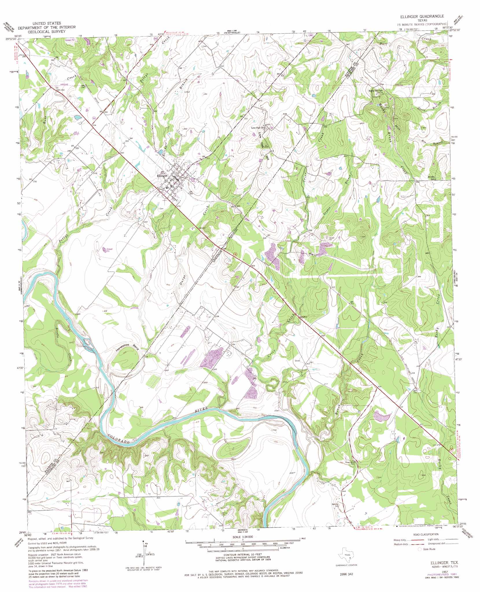
Ellinger Topo Map Texas
To zoom in, hover over the map of Ellinger
USGS Topo Quad 29096g6 - 1:24,000 scale
| Topo Map Name: | Ellinger |
| USGS Topo Quad ID: | 29096g6 |
| Print Size: | ca. 21 1/4" wide x 27" high |
| Southeast Coordinates: | 29.75° N latitude / 96.625° W longitude |
| Map Center Coordinates: | 29.8125° N latitude / 96.6875° W longitude |
| U.S. State: | TX |
| Filename: | o29096g6.jpg |
| Download Map JPG Image: | Ellinger topo map 1:24,000 scale |
| Map Type: | Topographic |
| Topo Series: | 7.5´ |
| Map Scale: | 1:24,000 |
| Source of Map Images: | United States Geological Survey (USGS) |
| Alternate Map Versions: |
Ellinger TX 1957, updated 1958 Download PDF Buy paper map Ellinger TX 1957, updated 1982 Download PDF Buy paper map Ellinger TX 2010 Download PDF Buy paper map Ellinger TX 2013 Download PDF Buy paper map Ellinger TX 2016 Download PDF Buy paper map |
1:24,000 Topo Quads surrounding Ellinger
Warda |
Nechanitz |
Round Top |
Greenvine |
Welcome |
La Grange West |
La Grange East |
Fayetteville |
Industry |
New Ulm |
Swiss Alp |
Ammannsville |
Ellinger |
Frelsburg |
Bernardo |
Schulenburg |
Weimar |
Borden |
Columbus |
Alleyton |
Moravia |
Oakland |
Sawmill Branch |
Rock Island |
Altair |
> Back to 29096e1 at 1:100,000 scale
> Back to 29096a1 at 1:250,000 scale
> Back to U.S. Topo Maps home
Ellinger topo map: Gazetteer
Ellinger: Bends
Horseshoe Bend elevation 63m 206′Ellinger: Dams
Schindler Lake Dam elevation 91m 298′Ellinger: Populated Places
Ellinger elevation 90m 295′Ellinger: Reservoirs
Schindler Lake elevation 91m 298′Ellinger: Streams
Brush Creek elevation 56m 183′Brushy Creek elevation 56m 183′
Crier Creek elevation 61m 200′
Dutys Creek elevation 59m 193′
Fllinger Branch elevation 70m 229′
Pettys Creek elevation 59m 193′
Snyder Branch elevation 87m 285′
Ellinger: Summits
Live Oak Hill elevation 126m 413′Rocky Hill elevation 137m 449′
Ellinger digital topo map on disk
Buy this Ellinger topo map showing relief, roads, GPS coordinates and other geographical features, as a high-resolution digital map file on DVD: