Fayetteville Topo Map Texas
To zoom in, hover over the map of Fayetteville
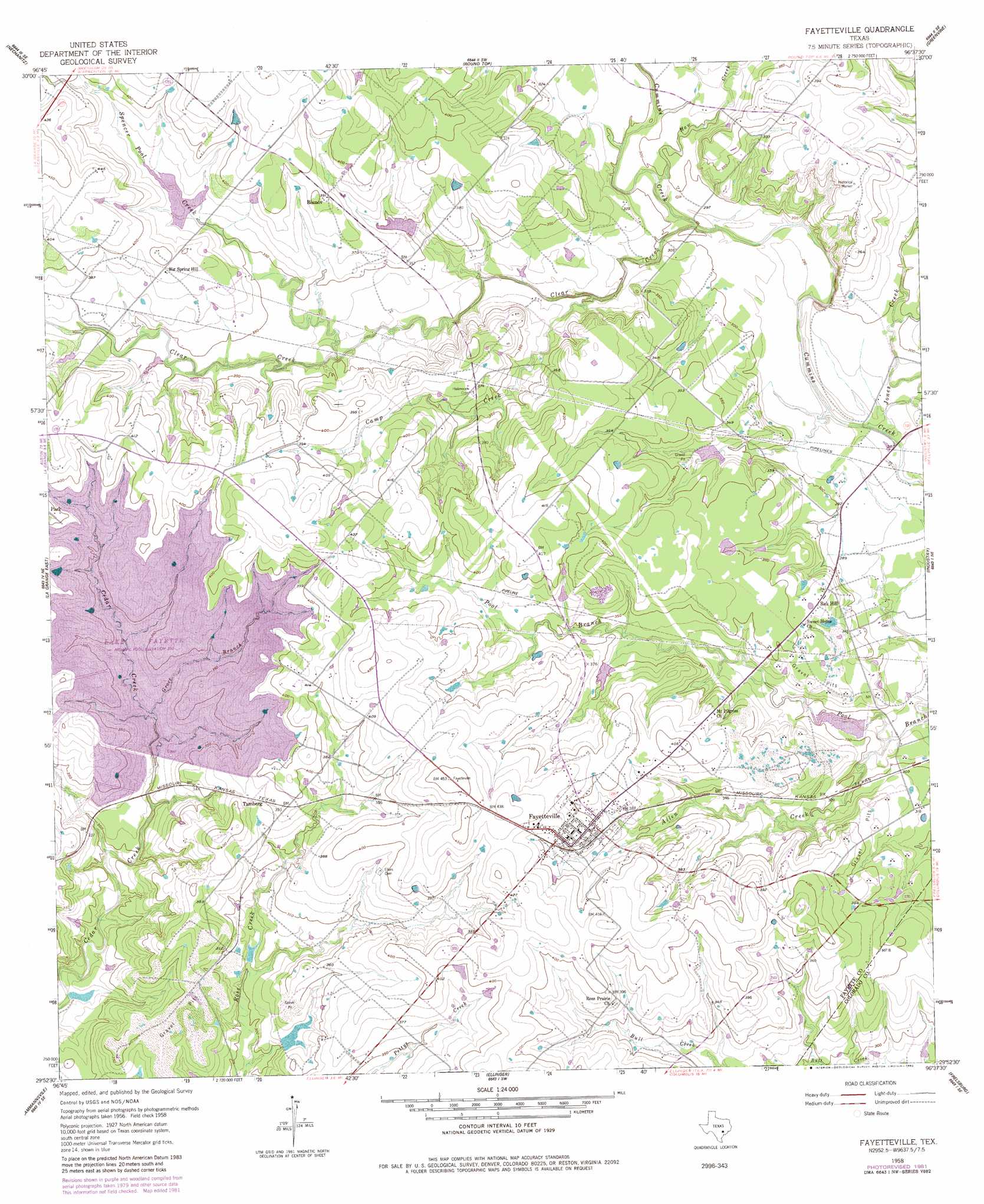
USGS Topo Quad 29096h6 - 1:24,000 scale
| Topo Map Name: | Fayetteville |
| USGS Topo Quad ID: | 29096h6 |
| Print Size: | ca. 21 1/4" wide x 27" high |
| Southeast Coordinates: | 29.875° N latitude / 96.625° W longitude |
| Map Center Coordinates: | 29.9375° N latitude / 96.6875° W longitude |
| U.S. State: | TX |
| Filename: | o29096h6.jpg |
| Download Map JPG Image: | Fayetteville topo map 1:24,000 scale |
| Map Type: | Topographic |
| Topo Series: | 7.5´ |
| Map Scale: | 1:24,000 |
| Source of Map Images: | United States Geological Survey (USGS) |
| Alternate Map Versions: |
Fayetteville TX 1958, updated 1959 Download PDF Buy paper map Fayetteville TX 1958, updated 1959 Download PDF Buy paper map Fayetteville TX 1958, updated 1982 Download PDF Buy paper map Fayetteville TX 2010 Download PDF Buy paper map Fayetteville TX 2013 Download PDF Buy paper map Fayetteville TX 2016 Download PDF Buy paper map |
1:24,000 Topo Quads surrounding Fayetteville
Giddings |
Ledbetter |
Carmine |
Burton |
Brenham |
Warda |
Nechanitz |
Round Top |
Greenvine |
Welcome |
La Grange West |
La Grange East |
Fayetteville |
Industry |
New Ulm |
Swiss Alp |
Ammannsville |
Ellinger |
Frelsburg |
Bernardo |
Schulenburg |
Weimar |
Borden |
Columbus |
Alleyton |
> Back to 29096e1 at 1:100,000 scale
> Back to 29096a1 at 1:250,000 scale
> Back to U.S. Topo Maps home
Fayetteville topo map: Gazetteer
Fayetteville: Dams
Cedar Creek Dam elevation 95m 311′Soil Conservation Service Site 23 Dam elevation 109m 357′
Soil Conservation Service Site 24 Dam elevation 103m 337′
Soil Conservation Service Site 25 Dam elevation 94m 308′
Soil Conservation Service Site 29 Dam elevation 105m 344′
Soil Conservation Service Site 30 Dam elevation 87m 285′
Texas No Name Number 53 Dam elevation 94m 308′
Fayetteville: Populated Places
Fayetteville elevation 121m 396′Rek Hill elevation 104m 341′
Roznov elevation 116m 380′
Tamberg elevation 119m 390′
Fayetteville: Reservoirs
Cedar Creek Reservoir elevation 119m 390′Soil Conservation Service Site 23 Reservoir elevation 109m 357′
Soil Conservation Service Site 24 Reservoir elevation 103m 337′
Soil Conservation Service Site 25 Reservoir elevation 94m 308′
Soil Conservation Service Site 29 Reservoir elevation 105m 344′
Soil Conservation Service Site 30 Reservoir elevation 87m 285′
Fayetteville: Streams
Allen Creek elevation 82m 269′Camp Creek elevation 89m 291′
Clear Creek elevation 86m 282′
Groce Branch elevation 119m 390′
Haw Creek elevation 90m 295′
Jones Creek elevation 82m 269′
Spencer Pool Creek elevation 98m 321′
Fayetteville digital topo map on disk
Buy this Fayetteville topo map showing relief, roads, GPS coordinates and other geographical features, as a high-resolution digital map file on DVD: