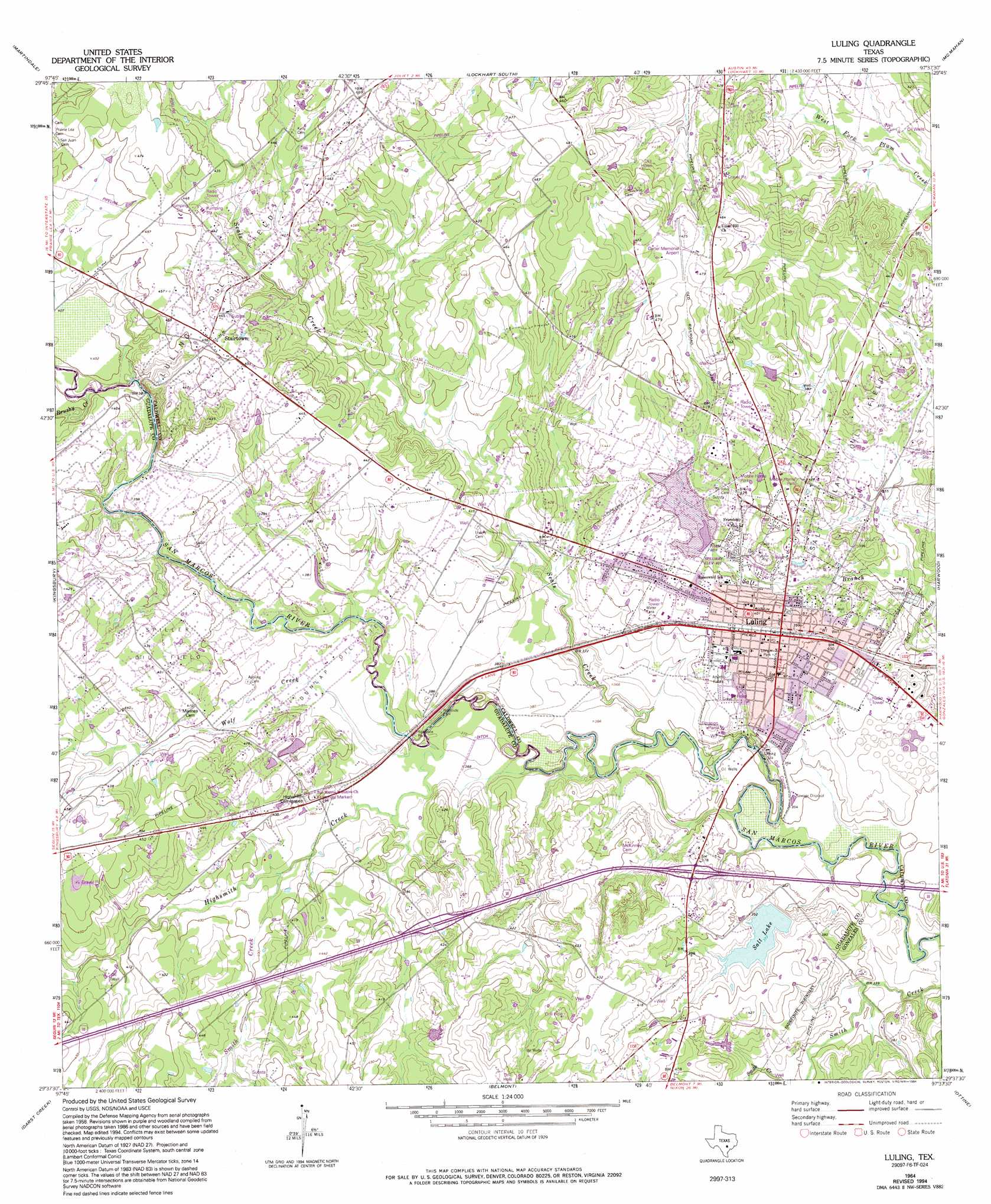
Luling Topo Map Texas
To zoom in, hover over the map of Luling
USGS Topo Quad 29097f6 - 1:24,000 scale
| Topo Map Name: | Luling |
| USGS Topo Quad ID: | 29097f6 |
| Print Size: | ca. 21 1/4" wide x 27" high |
| Southeast Coordinates: | 29.625° N latitude / 97.625° W longitude |
| Map Center Coordinates: | 29.6875° N latitude / 97.6875° W longitude |
| U.S. State: | TX |
| Filename: | o29097f6.jpg |
| Download Map JPG Image: | Luling topo map 1:24,000 scale |
| Map Type: | Topographic |
| Topo Series: | 7.5´ |
| Map Scale: | 1:24,000 |
| Source of Map Images: | United States Geological Survey (USGS) |
| Alternate Map Versions: |
Luling TX 1964, updated 1966 Download PDF Buy paper map Luling TX 1964, updated 1975 Download PDF Buy paper map Luling TX 1964, updated 1994 Download PDF Buy paper map Luling TX 2010 Download PDF Buy paper map Luling TX 2013 Download PDF Buy paper map Luling TX 2016 Download PDF Buy paper map |
1:24,000 Topo Quads surrounding Luling
San Marcos North |
Uhland |
Lockhart North |
Dale |
Red Rock |
San Marcos South |
Martindale |
Lockhart South |
Mcmahan |
Delhi |
Geronimo |
Kingsbury |
Luling |
Harwood |
Sandy Fork |
Seguin |
Darst Creek |
Belmont |
Ottine |
Gonzales North |
Thomas Springs |
Dewville |
Leesville |
Cost |
Gonzales South |
> Back to 29097e1 at 1:100,000 scale
> Back to 29096a1 at 1:250,000 scale
> Back to U.S. Topo Maps home
Luling topo map: Gazetteer
Luling: Airports
The Carter Memorial Airport elevation 143m 469′Luling: Dams
Carter Lake Dam elevation 121m 396′Rose Lake Dam elevation 114m 374′
Soil Conservation Service Site 38 Dam elevation 119m 390′
Luling: Oilfields
Dunlap Oil Field elevation 114m 374′Luling Oil Field elevation 134m 439′
Spiller Oil Field elevation 127m 416′
Luling: Parks
Longer Park elevation 123m 403′Northside Park elevation 124m 406′
Southside Park elevation 108m 354′
Luling: Populated Places
Luling elevation 125m 410′Stairtown elevation 139m 456′
Luling: Reservoirs
Carter Lake elevation 121m 396′Rose Lake elevation 114m 374′
Salt Lake elevation 110m 360′
Soil Conservation Service Site 38 Reservoir elevation 119m 390′
Luling: Streams
Brushy Creek elevation 115m 377′Highsmith Creek elevation 107m 351′
Rocky Creek elevation 110m 360′
Seals Creek elevation 104m 341′
Smith Creek elevation 114m 374′
Wolf Creek elevation 106m 347′
Luling digital topo map on disk
Buy this Luling topo map showing relief, roads, GPS coordinates and other geographical features, as a high-resolution digital map file on DVD: