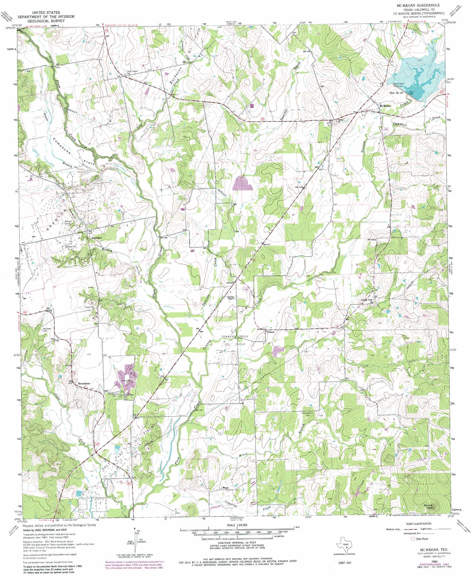
Mcmahan Topo Map Texas
To zoom in, hover over the map of Mcmahan
USGS Topo Quad 29097g5 - 1:24,000 scale
| Topo Map Name: | Mcmahan |
| USGS Topo Quad ID: | 29097g5 |
| Print Size: | ca. 21 1/4" wide x 27" high |
| Southeast Coordinates: | 29.75° N latitude / 97.5° W longitude |
| Map Center Coordinates: | 29.8125° N latitude / 97.5625° W longitude |
| U.S. State: | TX |
| Filename: | o29097g5.jpg |
| Download Map JPG Image: | Mcmahan topo map 1:24,000 scale |
| Map Type: | Topographic |
| Topo Series: | 7.5´ |
| Map Scale: | 1:24,000 |
| Source of Map Images: | United States Geological Survey (USGS) |
| Alternate Map Versions: |
McMahan TX 1963, updated 1966 Download PDF Buy paper map McMahan TX 1963, updated 1982 Download PDF Buy paper map McMahan TX 2010 Download PDF Buy paper map McMahan TX 2013 Download PDF Buy paper map McMahan TX 2016 Download PDF Buy paper map |
1:24,000 Topo Quads surrounding Mcmahan
Buda |
Creedmoor |
Lytton Springs |
Bastrop Sw |
Bastrap |
Uhland |
Lockhart North |
Dale |
Red Rock |
Rosanky |
Martindale |
Lockhart South |
Mcmahan |
Delhi |
Jeddo |
Kingsbury |
Luling |
Harwood |
Sandy Fork |
Waelder |
Darst Creek |
Belmont |
Ottine |
Gonzales North |
Dilworth |
> Back to 29097e1 at 1:100,000 scale
> Back to 29096a1 at 1:250,000 scale
> Back to U.S. Topo Maps home
Mcmahan topo map: Gazetteer
Mcmahan: Dams
Soil Conservation Service Site 27 Dam elevation 124m 406′Soil Conservation Service Site 28 Dam elevation 139m 456′
Soil Conservation Service Site 31 Dam elevation 119m 390′
Mcmahan: Flats
Comanche Flats elevation 123m 403′Mcmahan: Oilfields
Branyon Oil Field elevation 133m 436′Tenney Creek Oil Field elevation 116m 380′
Mcmahan: Populated Places
Brownsboro elevation 137m 449′McMahan elevation 135m 442′
Seawillow elevation 125m 410′
Tilmon elevation 120m 393′
Watts elevation 121m 396′
Mcmahan: Reservoirs
Site Number Twentyeight elevation 140m 459′Soil Conservation Service Site 27 Reservoir elevation 124m 406′
Soil Conservation Service Site 28 Reservoir elevation 139m 456′
Soil Conservation Service Site 31 Reservoir elevation 119m 390′
Mcmahan: Streams
Campbell Creek elevation 131m 429′Clear Fork Plum Creek elevation 108m 354′
Copperas Creek elevation 110m 360′
Daniels Creek elevation 114m 374′
Dry Creek elevation 119m 390′
Hines Branch elevation 110m 360′
Linscome Creek elevation 125m 410′
Pecan Branch elevation 117m 383′
Sixmile Branch elevation 119m 390′
Tenney Creek elevation 113m 370′
Mcmahan: Summits
Round Mountain elevation 214m 702′Mcmahan digital topo map on disk
Buy this Mcmahan topo map showing relief, roads, GPS coordinates and other geographical features, as a high-resolution digital map file on DVD: