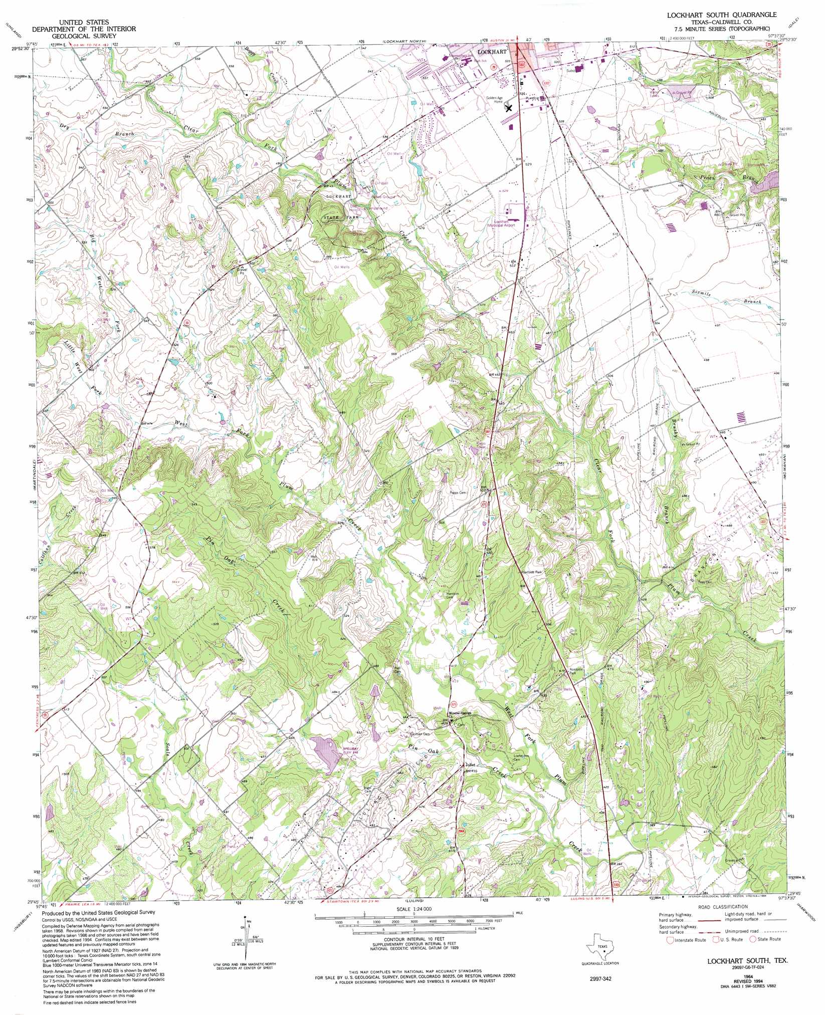
Lockhart South Topo Map Texas
To zoom in, hover over the map of Lockhart South
USGS Topo Quad 29097g6 - 1:24,000 scale
| Topo Map Name: | Lockhart South |
| USGS Topo Quad ID: | 29097g6 |
| Print Size: | ca. 21 1/4" wide x 27" high |
| Southeast Coordinates: | 29.75° N latitude / 97.625° W longitude |
| Map Center Coordinates: | 29.8125° N latitude / 97.6875° W longitude |
| U.S. State: | TX |
| Filename: | o29097g6.jpg |
| Download Map JPG Image: | Lockhart South topo map 1:24,000 scale |
| Map Type: | Topographic |
| Topo Series: | 7.5´ |
| Map Scale: | 1:24,000 |
| Source of Map Images: | United States Geological Survey (USGS) |
| Alternate Map Versions: |
Lockhart South TX 1964, updated 1966 Download PDF Buy paper map Lockhart South TX 1964, updated 1975 Download PDF Buy paper map Lockhart South TX 1964, updated 1994 Download PDF Buy paper map Lockhart South TX 2010 Download PDF Buy paper map Lockhart South TX 2013 Download PDF Buy paper map Lockhart South TX 2016 Download PDF Buy paper map |
1:24,000 Topo Quads surrounding Lockhart South
Mountain City |
Buda |
Creedmoor |
Lytton Springs |
Bastrop Sw |
San Marcos North |
Uhland |
Lockhart North |
Dale |
Red Rock |
San Marcos South |
Martindale |
Lockhart South |
Mcmahan |
Delhi |
Geronimo |
Kingsbury |
Luling |
Harwood |
Sandy Fork |
Seguin |
Darst Creek |
Belmont |
Ottine |
Gonzales North |
> Back to 29097e1 at 1:100,000 scale
> Back to 29096a1 at 1:250,000 scale
> Back to U.S. Topo Maps home
Lockhart South topo map: Gazetteer
Lockhart South: Airports
Lockhart Municipal Airport elevation 160m 524′Lockhart South: Dams
Soil Conservation Service Site 23 Dam elevation 131m 429′Soil Conservation Service Site 37 Dam elevation 135m 442′
Lockhart South: Oilfields
Luling Oil Field elevation 137m 449′Lockhart South: Parks
Lockhart State Park elevation 162m 531′Lockhart South: Populated Places
Joliet elevation 127m 416′Mineral Springs (historical) elevation 137m 449′
Lockhart South: Reservoirs
Soil Conservation Service Site 23 Reservoir elevation 131m 429′Soil Conservation Service Site 37 Reservoir elevation 135m 442′
Lockhart South: Streams
Big West Fork Plum Creek elevation 144m 472′Boggy Creek elevation 151m 495′
Brushy Branch elevation 122m 400′
Dry Branch elevation 155m 508′
Little West Fork Plum Creek elevation 144m 472′
Pin Oak Creek elevation 116m 380′
Lockhart South: Trails
Lockhart State Park Trail elevation 162m 531′Lockhart South digital topo map on disk
Buy this Lockhart South topo map showing relief, roads, GPS coordinates and other geographical features, as a high-resolution digital map file on DVD: