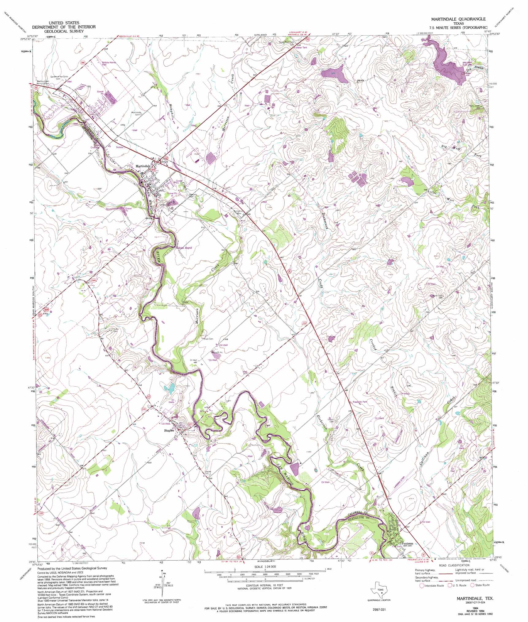
Martindale Topo Map Texas
To zoom in, hover over the map of Martindale
USGS Topo Quad 29097g7 - 1:24,000 scale
| Topo Map Name: | Martindale |
| USGS Topo Quad ID: | 29097g7 |
| Print Size: | ca. 21 1/4" wide x 27" high |
| Southeast Coordinates: | 29.75° N latitude / 97.75° W longitude |
| Map Center Coordinates: | 29.8125° N latitude / 97.8125° W longitude |
| U.S. State: | TX |
| Filename: | o29097g7.jpg |
| Download Map JPG Image: | Martindale topo map 1:24,000 scale |
| Map Type: | Topographic |
| Topo Series: | 7.5´ |
| Map Scale: | 1:24,000 |
| Source of Map Images: | United States Geological Survey (USGS) |
| Alternate Map Versions: |
Martindale TX 1964, updated 1966 Download PDF Buy paper map Martindale TX 1964, updated 1975 Download PDF Buy paper map Martindale TX 1964, updated 1994 Download PDF Buy paper map Martindale TX 2010 Download PDF Buy paper map Martindale TX 2013 Download PDF Buy paper map Martindale TX 2016 Download PDF Buy paper map |
1:24,000 Topo Quads surrounding Martindale
Driftwood |
Mountain City |
Buda |
Creedmoor |
Lytton Springs |
Wimberley |
San Marcos North |
Uhland |
Lockhart North |
Dale |
Hunter |
San Marcos South |
Martindale |
Lockhart South |
Mcmahan |
New Braunfels East |
Geronimo |
Kingsbury |
Luling |
Harwood |
Mcqueeney |
Seguin |
Darst Creek |
Belmont |
Ottine |
> Back to 29097e1 at 1:100,000 scale
> Back to 29096a1 at 1:250,000 scale
> Back to U.S. Topo Maps home
Martindale topo map: Gazetteer
Martindale: Airports
Fentress Airpark elevation 139m 456′Martindale: Dams
Cooper Lake Dam elevation 173m 567′Grouskay-Fisher Lake Dam elevation 164m 538′
Langford Lake Dam elevation 138m 452′
Soil Conservation Service Site 34 Dam elevation 169m 554′
Martindale: Populated Places
Fentress elevation 136m 446′Martindale elevation 160m 524′
Staples elevation 159m 521′
Martindale: Reservoirs
Cooper Lake elevation 173m 567′Grouskay-Fisher Lake elevation 164m 538′
Langford Lake elevation 138m 452′
Soil Conservation Service Site 34 Reservoir elevation 169m 554′
Martindale: Springs
Barber Springs elevation 171m 561′Martindale: Streams
Crooked Branch elevation 134m 439′Dickerson Creek elevation 129m 423′
Hemphill Creek elevation 156m 511′
Morrison Creek elevation 141m 462′
Martindale digital topo map on disk
Buy this Martindale topo map showing relief, roads, GPS coordinates and other geographical features, as a high-resolution digital map file on DVD: