Lockhart North Topo Map Texas
To zoom in, hover over the map of Lockhart North
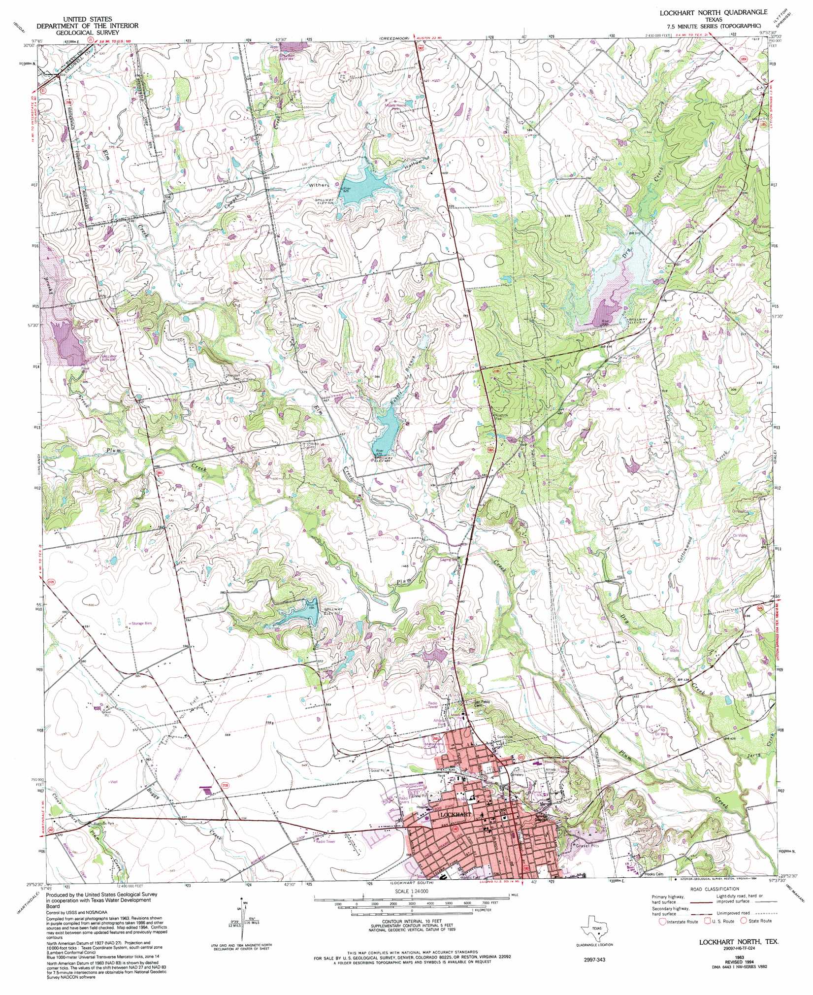
USGS Topo Quad 29097h6 - 1:24,000 scale
| Topo Map Name: | Lockhart North |
| USGS Topo Quad ID: | 29097h6 |
| Print Size: | ca. 21 1/4" wide x 27" high |
| Southeast Coordinates: | 29.875° N latitude / 97.625° W longitude |
| Map Center Coordinates: | 29.9375° N latitude / 97.6875° W longitude |
| U.S. State: | TX |
| Filename: | o29097h6.jpg |
| Download Map JPG Image: | Lockhart North topo map 1:24,000 scale |
| Map Type: | Topographic |
| Topo Series: | 7.5´ |
| Map Scale: | 1:24,000 |
| Source of Map Images: | United States Geological Survey (USGS) |
| Alternate Map Versions: |
Lockhart North TX 1963, updated 1966 Download PDF Buy paper map Lockhart North TX 1963, updated 1974 Download PDF Buy paper map Lockhart North TX 1963, updated 1994 Download PDF Buy paper map Lockhart North TX 2010 Download PDF Buy paper map Lockhart North TX 2013 Download PDF Buy paper map Lockhart North TX 2016 Download PDF Buy paper map |
1:24,000 Topo Quads surrounding Lockhart North
Signal Hill |
Oak Hill |
Montopolis |
Webberville |
Utley |
Mountain City |
Buda |
Creedmoor |
Lytton Springs |
Bastrop Sw |
San Marcos North |
Uhland |
Lockhart North |
Dale |
Red Rock |
San Marcos South |
Martindale |
Lockhart South |
Mcmahan |
Delhi |
Geronimo |
Kingsbury |
Luling |
Harwood |
Sandy Fork |
> Back to 29097e1 at 1:100,000 scale
> Back to 29096a1 at 1:250,000 scale
> Back to U.S. Topo Maps home
Lockhart North topo map: Gazetteer
Lockhart North: Airports
Brooks Place Airport elevation 148m 485′Lockhart North: Bridges
State Highway 3-A Bridge elevation 134m 439′Lockhart North: Dams
Barth Lake Dam elevation 146m 479′Segler Lake Dam elevation 153m 501′
Soil Conservation Service Site 14 Dam elevation 159m 521′
Soil Conservation Service Site 15 Dam elevation 151m 495′
Soil Conservation Service Site 18 Dam elevation 163m 534′
Soil Conservation Service Site 20 Dam elevation 149m 488′
Soil Conservation Service Site 21 Dam elevation 153m 501′
Lockhart North: Parks
Lockhart City Park elevation 160m 524′Lockhart North: Populated Places
Lockhart elevation 157m 515′Lockhart North: Reservoirs
Barth Lake elevation 146m 479′Segler Lake elevation 153m 501′
Site Number Eighteen elevation 160m 524′
Site Number Fifteen elevation 153m 501′
Site Number Twenty elevation 148m 485′
Site Number Twentyone elevation 159m 521′
Soil Conservation Service Site 14 Reservoir elevation 159m 521′
Soil Conservation Service Site 15 Reservoir elevation 151m 495′
Soil Conservation Service Site 18 Reservoir elevation 163m 534′
Soil Conservation Service Site 20 Reservoir elevation 149m 488′
Soil Conservation Service Site 21 Reservoir elevation 153m 501′
Lockhart North: Streams
Brushy Creek elevation 146m 479′Cottonwood Creek elevation 132m 433′
Cowpen Creek elevation 146m 479′
Dry Creek elevation 127m 416′
Elm Creek elevation 134m 439′
Jerry Creek elevation 128m 419′
Rabbit Branch elevation 137m 449′
Town Branch elevation 125m 410′
Lockhart North: Valleys
Withers Hollow elevation 152m 498′Lockhart North digital topo map on disk
Buy this Lockhart North topo map showing relief, roads, GPS coordinates and other geographical features, as a high-resolution digital map file on DVD: