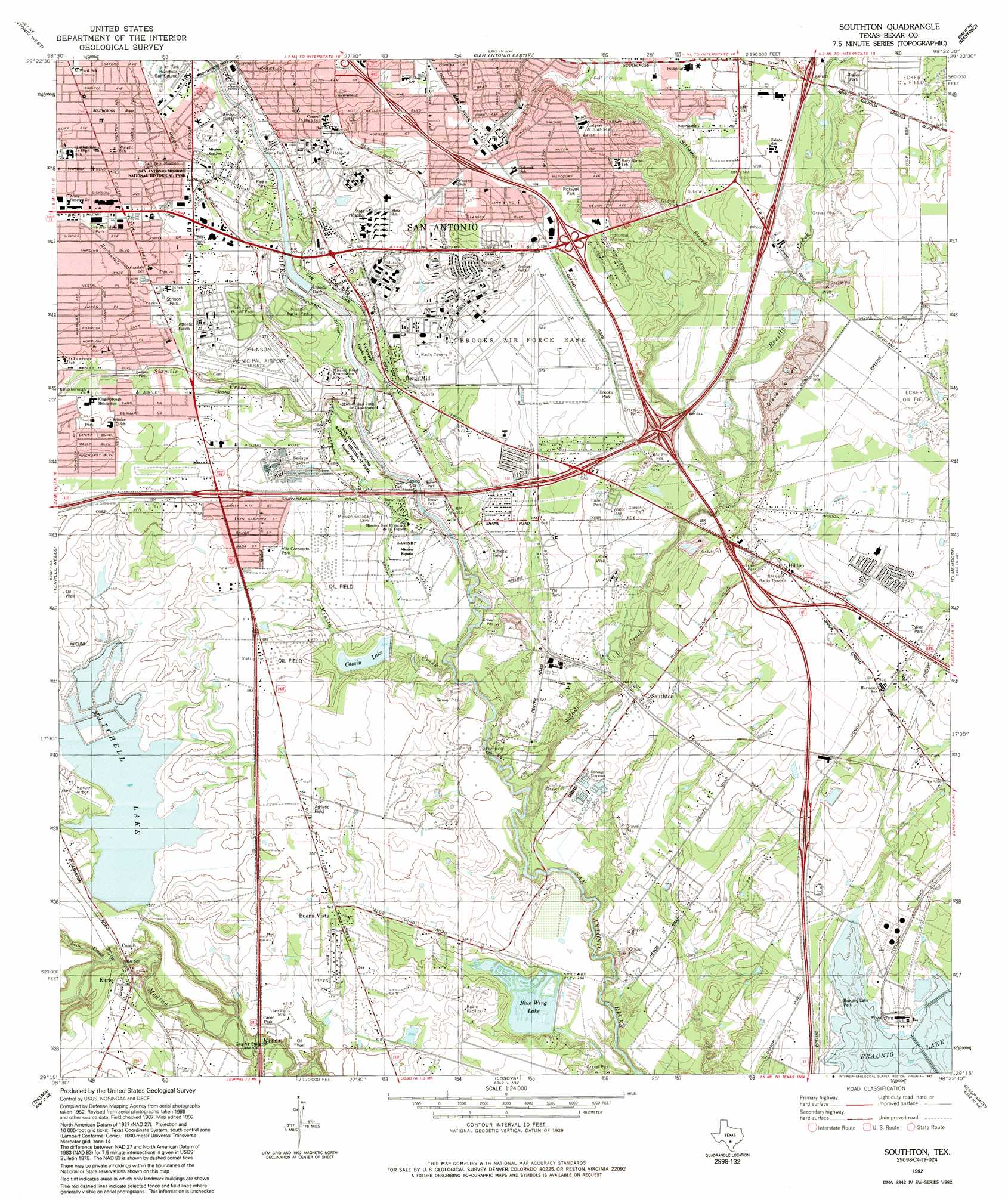
Southton Topo Map Texas
To zoom in, hover over the map of Southton
USGS Topo Quad 29098c4 - 1:24,000 scale
| Topo Map Name: | Southton |
| USGS Topo Quad ID: | 29098c4 |
| Print Size: | ca. 21 1/4" wide x 27" high |
| Southeast Coordinates: | 29.25° N latitude / 98.375° W longitude |
| Map Center Coordinates: | 29.3125° N latitude / 98.4375° W longitude |
| U.S. State: | TX |
| Filename: | o29098c4.jpg |
| Download Map JPG Image: | Southton topo map 1:24,000 scale |
| Map Type: | Topographic |
| Topo Series: | 7.5´ |
| Map Scale: | 1:24,000 |
| Source of Map Images: | United States Geological Survey (USGS) |
| Alternate Map Versions: |
Southton TX 1953, updated 1959 Download PDF Buy paper map Southton TX 1967, updated 1969 Download PDF Buy paper map Southton TX 1967, updated 1970 Download PDF Buy paper map Southton TX 1967, updated 1984 Download PDF Buy paper map Southton TX 1992, updated 1992 Download PDF Buy paper map Southton TX 2010 Download PDF Buy paper map Southton TX 2013 Download PDF Buy paper map Southton TX 2016 Download PDF Buy paper map |
1:24,000 Topo Quads surrounding Southton
Helotes |
Castle Hills |
Longhorn |
Schertz |
Marion |
Culebra Hill |
San Antonio West |
San Antonio East |
Martinez |
Saint Hedwig |
Macdona |
Terrell Wells |
Southton |
Elmendorf |
La Vernia Sw |
Somerset |
Thelma |
Losoya |
Saspamco |
Floresville |
Rossville |
Poteet |
Leming |
Saspamco Se |
Dewees |
> Back to 29098a1 at 1:100,000 scale
> Back to 29098a1 at 1:250,000 scale
> Back to U.S. Topo Maps home
Southton topo map: Gazetteer
Southton: Airports
A W Ranch Airport elevation 158m 518′Department of Public Safety Heliport elevation 197m 646′
Harmony Field elevation 171m 561′
Rio Medina Airport elevation 158m 518′
Stinson Municipal Airport elevation 172m 564′
Southton: Canals
Espada Aqueduct elevation 161m 528′Espada Ditch elevation 160m 524′
San Juan Ditch elevation 164m 538′
Southton: Crossings
Interchange 132 elevation 165m 541′Interchange 133 elevation 164m 538′
Interchange 135 elevation 185m 606′
Interchange 136 elevation 187m 613′
Interchange 137 elevation 188m 616′
Interchange 37 elevation 177m 580′
Interchange 39 elevation 177m 580′
Interchange 41 elevation 165m 541′
Interchange 42 elevation 169m 554′
Interchange 44 elevation 185m 606′
Southton: Dams
Blue Wing Lake Dam elevation 146m 479′Cassin Lake Dam elevation 161m 528′
Espada Dam elevation 163m 534′
Mitchell Lake Dam elevation 168m 551′
New Espada Lake Dam elevation 162m 531′
Southton: Oilfields
Eckert Oil Field elevation 183m 600′Southton Oil Field elevation 164m 538′
Southton: Parks
Bellaire Park elevation 174m 570′Braunig Park elevation 157m 515′
Brooks Park elevation 174m 570′
Brown Park elevation 152m 498′
Espada Park elevation 162m 531′
Harlandale Memorial Stadium elevation 177m 580′
Harlandale Park elevation 185m 606′
J F Kennedy Memorial elevation 161m 528′
Kingsborough Park elevation 185m 606′
Mission County Park elevation 171m 561′
Mission Park elevation 161m 528′
Mission San Juan de Capistrano elevation 160m 524′
Padre Park elevation 170m 557′
Pickwell Park elevation 198m 649′
Pytel Park elevation 195m 639′
San Antonio Missions National Historical Park elevation 159m 521′
Stinson Park elevation 178m 583′
Villa Coronado Park elevation 175m 574′
Southton: Populated Places
Bergs Mill elevation 166m 544′Buena Vista elevation 164m 538′
Cassin elevation 161m 528′
Earle elevation 155m 508′
Hilltop elevation 173m 567′
Southton elevation 155m 508′
Southton: Post Offices
Harlandale Post Office elevation 187m 613′Southton: Reservoirs
Blue Wing Lake elevation 146m 479′Cassin Lake elevation 155m 508′
Mitchell Lake elevation 159m 521′
New Espada Lake elevation 162m 531′
Southton: Springs
Mitchell Lake Spring elevation 158m 518′Southton: Streams
Harlandale Creek elevation 169m 554′Leon Creek elevation 142m 465′
Minita Creek elevation 148m 485′
Rosillo Creek elevation 155m 508′
Salado Creek elevation 144m 472′
Sixmile Creek elevation 156m 511′
Southton digital topo map on disk
Buy this Southton topo map showing relief, roads, GPS coordinates and other geographical features, as a high-resolution digital map file on DVD: