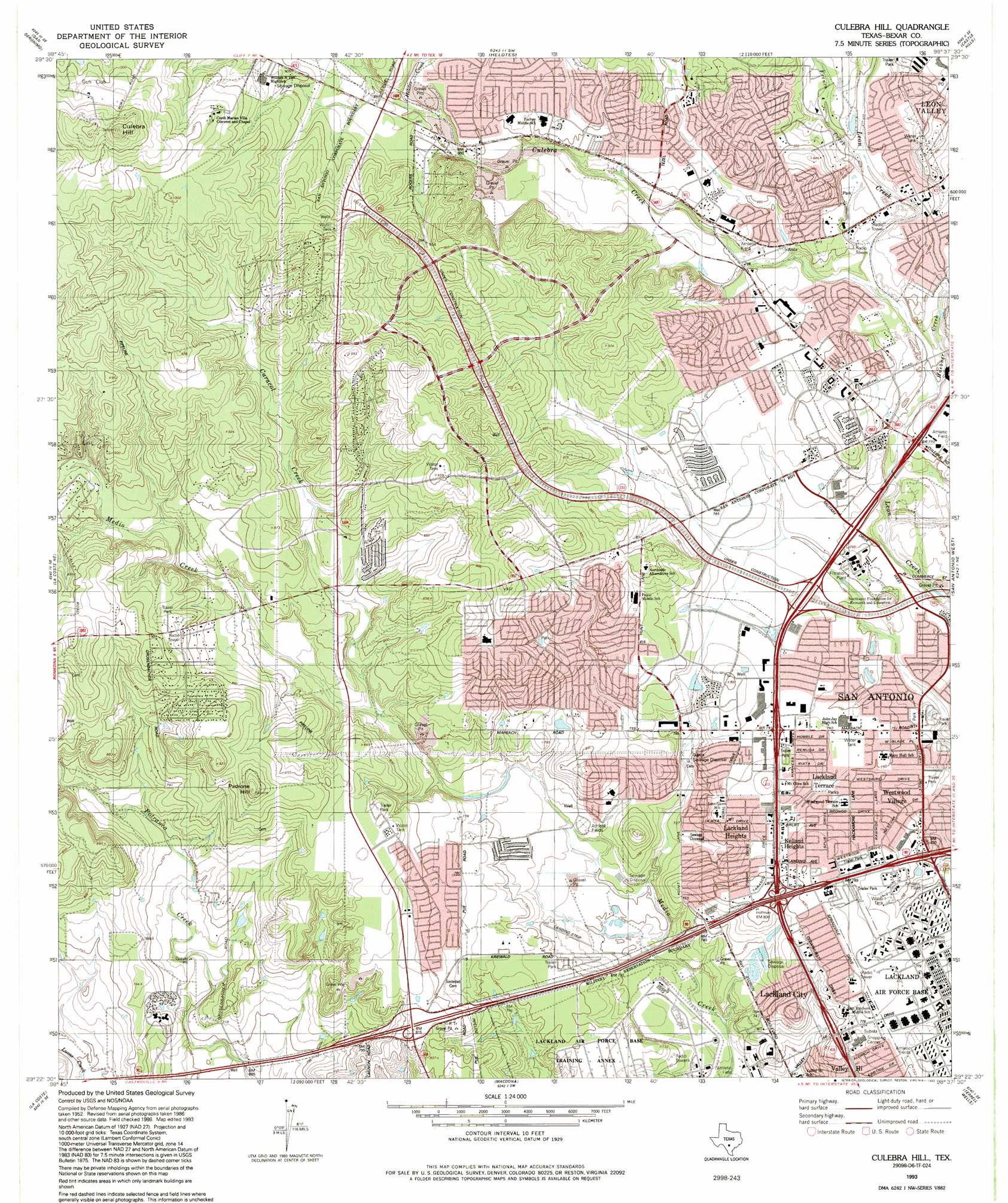
Culebra Hill Topo Map Texas
To zoom in, hover over the map of Culebra Hill
USGS Topo Quad 29098d6 - 1:24,000 scale
| Topo Map Name: | Culebra Hill |
| USGS Topo Quad ID: | 29098d6 |
| Print Size: | ca. 21 1/4" wide x 27" high |
| Southeast Coordinates: | 29.375° N latitude / 98.625° W longitude |
| Map Center Coordinates: | 29.4375° N latitude / 98.6875° W longitude |
| U.S. State: | TX |
| Filename: | o29098d6.jpg |
| Download Map JPG Image: | Culebra Hill topo map 1:24,000 scale |
| Map Type: | Topographic |
| Topo Series: | 7.5´ |
| Map Scale: | 1:24,000 |
| Source of Map Images: | United States Geological Survey (USGS) |
| Alternate Map Versions: |
Culebra Hill TX 1953, updated 1959 Download PDF Buy paper map Culebra Hill TX 1966, updated 1969 Download PDF Buy paper map Culebra Hill TX 1966, updated 1975 Download PDF Buy paper map Culebra Hill TX 1966, updated 1983 Download PDF Buy paper map Culebra Hill TX 1993, updated 1993 Download PDF Buy paper map Culebra Hill TX 1993, updated 1993 Download PDF Buy paper map Culebra Hill TX 2010 Download PDF Buy paper map Culebra Hill TX 2013 Download PDF Buy paper map Culebra Hill TX 2016 Download PDF Buy paper map |
1:24,000 Topo Quads surrounding Culebra Hill
Pipe Creek |
Jack Mountain |
Van Raub |
Camp Bullis |
Bulverde |
Medina Lake |
San Geronimo |
Helotes |
Castle Hills |
Longhorn |
Riomedina |
Lacoste Ne |
Culebra Hill |
San Antonio West |
San Antonio East |
Castroville |
Lacoste |
Macdona |
Terrell Wells |
Southton |
Devine |
Lytle |
Somerset |
Thelma |
Losoya |
> Back to 29098a1 at 1:100,000 scale
> Back to 29098a1 at 1:250,000 scale
> Back to U.S. Topo Maps home
Culebra Hill topo map: Gazetteer
Culebra Hill: Airports
Sony Microelectronics Helistop elevation 231m 757′Utilities Consolidated Incorporated Heliport elevation 240m 787′
Culebra Hill: Crossings
Interchange 3B elevation 229m 751′Interchange 4 elevation 226m 741′
Interchange 6 elevation 240m 787′
Culebra Hill: Parks
Gustafson - Northside Stadium elevation 233m 764′Lackland Terrace Park elevation 233m 764′
Northwest Little League - Senior Park elevation 245m 803′
Westwood Park elevation 234m 767′
Westwood Village Park elevation 226m 741′
Culebra Hill: Populated Places
Kelland Heights elevation 238m 780′Lackland City elevation 237m 777′
Lackland Heights elevation 238m 780′
Lackland Terrace elevation 231m 757′
Westwood Village elevation 228m 748′
Culebra Hill: Post Offices
Leon Valley Post Office elevation 263m 862′Valley Hi Post Office elevation 233m 764′
Culebra Hill: Streams
Caracol Creek elevation 232m 761′Culebra Creek elevation 230m 754′
French Creek elevation 245m 803′
Helotes Creek elevation 257m 843′
Huebner Creek elevation 232m 761′
Culebra Hill: Summits
Culebra Hill elevation 346m 1135′Padrone Hill elevation 280m 918′
Culebra Hill digital topo map on disk
Buy this Culebra Hill topo map showing relief, roads, GPS coordinates and other geographical features, as a high-resolution digital map file on DVD: