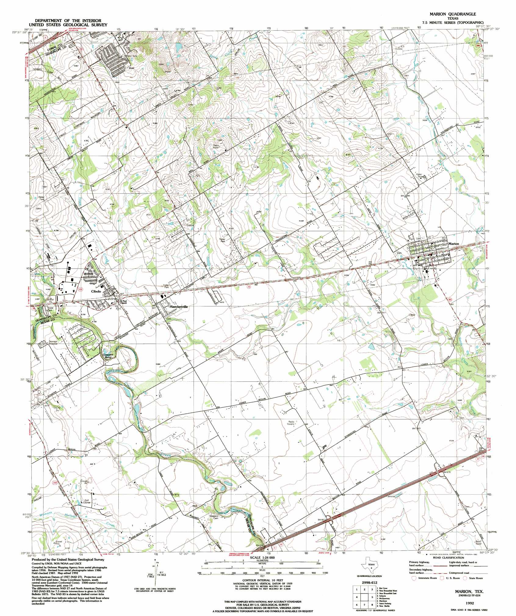
Marion Topo Map Texas
To zoom in, hover over the map of Marion
USGS Topo Quad 29098e2 - 1:24,000 scale
| Topo Map Name: | Marion |
| USGS Topo Quad ID: | 29098e2 |
| Print Size: | ca. 21 1/4" wide x 27" high |
| Southeast Coordinates: | 29.5° N latitude / 98.125° W longitude |
| Map Center Coordinates: | 29.5625° N latitude / 98.1875° W longitude |
| U.S. State: | TX |
| Filename: | o29098e2.jpg |
| Download Map JPG Image: | Marion topo map 1:24,000 scale |
| Map Type: | Topographic |
| Topo Series: | 7.5´ |
| Map Scale: | 1:24,000 |
| Source of Map Images: | United States Geological Survey (USGS) |
| Alternate Map Versions: |
Marion TX 1958, updated 1961 Download PDF Buy paper map Marion TX 1958, updated 1975 Download PDF Buy paper map Marion TX 1992, updated 1992 Download PDF Buy paper map Marion TX 1992, updated 1992 Download PDF Buy paper map Marion TX 2010 Download PDF Buy paper map Marion TX 2013 Download PDF Buy paper map Marion TX 2016 Download PDF Buy paper map |
1:24,000 Topo Quads surrounding Marion
Anhalt |
Smithson Valley |
Sattler |
Hunter |
San Marcos South |
Bulverde |
Bat Cave |
New Braunfels West |
New Braunfels East |
Geronimo |
Longhorn |
Schertz |
Marion |
Mcqueeney |
Seguin |
San Antonio East |
Martinez |
Saint Hedwig |
New Berlin |
Thomas Springs |
Southton |
Elmendorf |
La Vernia Sw |
La Vernia |
Alum |
> Back to 29098e1 at 1:100,000 scale
> Back to 29098a1 at 1:250,000 scale
> Back to U.S. Topo Maps home
Marion topo map: Gazetteer
Marion: Airports
H M Ranch Airport elevation 228m 748′Kardys Airport elevation 228m 748′
Marion: Arroyos
Dietz Creek elevation 207m 679′East Dietz Creek elevation 205m 672′
Town Creek elevation 207m 679′
West Dietz Creek elevation 205m 672′
Marion: Bends
Crescent Bend elevation 196m 643′Marion: Bridges
State Highway 3-A Bridge elevation 182m 597′Marion: Crossings
Interchange 597 elevation 185m 606′Interchange 600 elevation 188m 616′
Marion: Parks
Crescent Bend Nature Park elevation 209m 685′Marion: Populated Places
Cibolo elevation 213m 698′Haeckerville elevation 211m 692′
Marion elevation 197m 646′
Northcliff elevation 252m 826′
Marion digital topo map on disk
Buy this Marion topo map showing relief, roads, GPS coordinates and other geographical features, as a high-resolution digital map file on DVD: