Longhorn Topo Map Texas
To zoom in, hover over the map of Longhorn
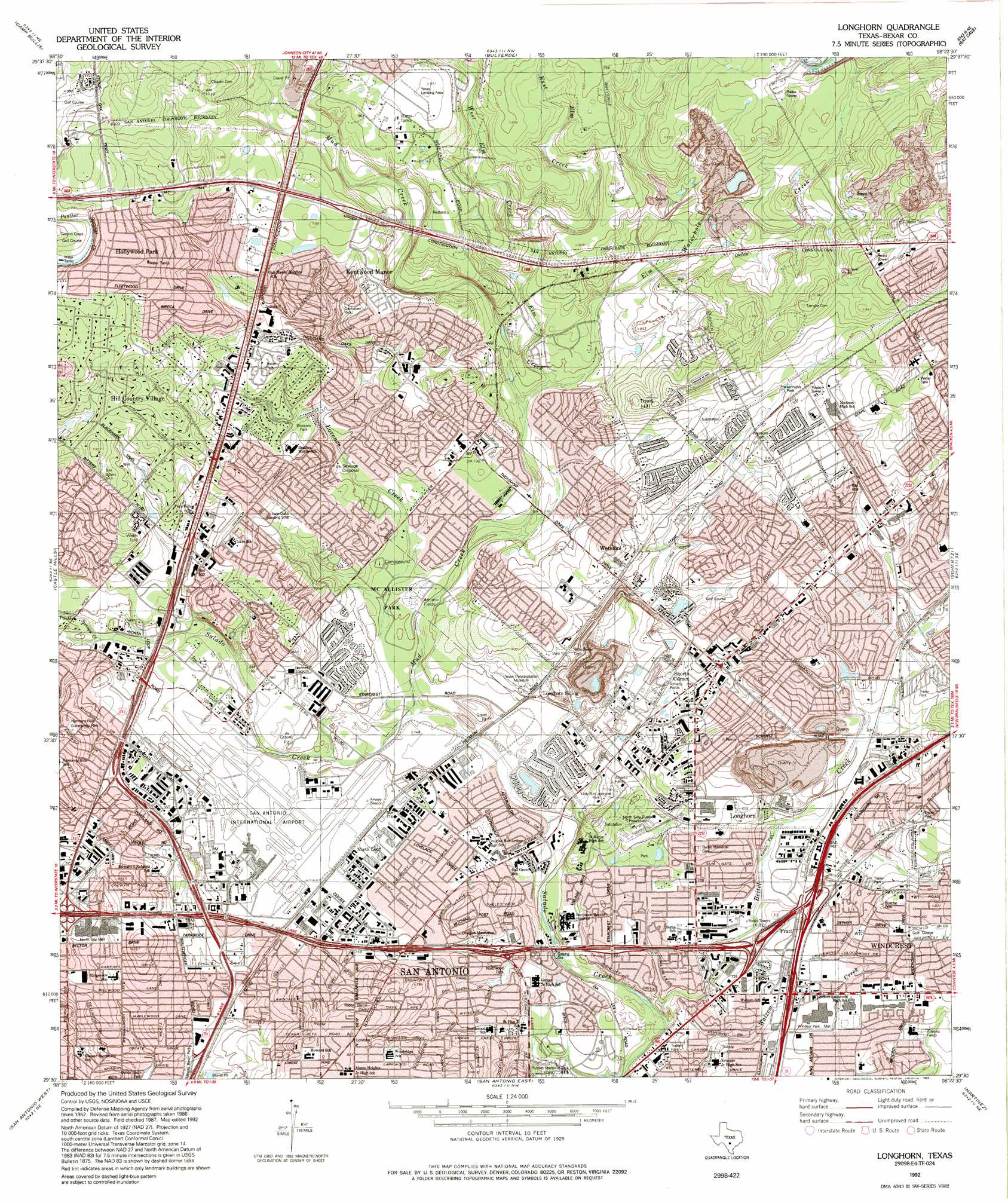
USGS Topo Quad 29098e4 - 1:24,000 scale
| Topo Map Name: | Longhorn |
| USGS Topo Quad ID: | 29098e4 |
| Print Size: | ca. 21 1/4" wide x 27" high |
| Southeast Coordinates: | 29.5° N latitude / 98.375° W longitude |
| Map Center Coordinates: | 29.5625° N latitude / 98.4375° W longitude |
| U.S. State: | TX |
| Filename: | o29098e4.jpg |
| Download Map JPG Image: | Longhorn topo map 1:24,000 scale |
| Map Type: | Topographic |
| Topo Series: | 7.5´ |
| Map Scale: | 1:24,000 |
| Source of Map Images: | United States Geological Survey (USGS) |
| Alternate Map Versions: |
Longhorn TX 1953, updated 1959 Download PDF Buy paper map Longhorn TX 1967, updated 1969 Download PDF Buy paper map Longhorn TX 1967, updated 1975 Download PDF Buy paper map Longhorn TX 1967, updated 1981 Download PDF Buy paper map Longhorn TX 1967, updated 1986 Download PDF Buy paper map Longhorn TX 1992, updated 1993 Download PDF Buy paper map Longhorn TX 1992, updated 1993 Download PDF Buy paper map Longhorn TX 2010 Download PDF Buy paper map Longhorn TX 2013 Download PDF Buy paper map Longhorn TX 2016 Download PDF Buy paper map |
1:24,000 Topo Quads surrounding Longhorn
Boerne |
Bergheim |
Anhalt |
Smithson Valley |
Sattler |
Van Raub |
Camp Bullis |
Bulverde |
Bat Cave |
New Braunfels West |
Helotes |
Castle Hills |
Longhorn |
Schertz |
Marion |
Culebra Hill |
San Antonio West |
San Antonio East |
Martinez |
Saint Hedwig |
Macdona |
Terrell Wells |
Southton |
Elmendorf |
La Vernia Sw |
> Back to 29098e1 at 1:100,000 scale
> Back to 29098a1 at 1:250,000 scale
> Back to U.S. Topo Maps home
Longhorn topo map: Gazetteer
Longhorn: Airports
G W Heliport elevation 242m 793′Rowco Incorporated Heliport elevation 237m 777′
San Antonio International Airport elevation 238m 780′
Twin-Oaks Airport elevation 248m 813′
Yates Airport elevation 293m 961′
Longhorn: Crossings
Interchange 164 elevation 225m 738′Interchange 165 elevation 225m 738′
Interchange 166 elevation 225m 738′
Interchange 167A elevation 232m 761′
Interchange 167B elevation 237m 777′
Interchange 168 elevation 249m 816′
Interchange 20 elevation 251m 823′
Interchange 20A elevation 242m 793′
Interchange 20B elevation 241m 790′
Interchange 20B elevation 241m 790′
Interchange 21 elevation 233m 764′
Interchange 21A elevation 244m 800′
Interchange 21B elevation 230m 754′
Interchange 22 elevation 234m 767′
Interchange 23 elevation 227m 744′
Interchange 24 elevation 224m 734′
Interchange 25A elevation 217m 711′
Interchange 25B elevation 219m 718′
Interchange 26 elevation 228m 748′
Interchange 26A elevation 218m 715′
Interchange 27 elevation 220m 721′
Longhorn: Dams
Eldorado Lake Dam elevation 241m 790′Northern Hills Lake Dam elevation 245m 803′
Soil Conservation Service Site 11 Dam elevation 253m 830′
Soil Conservation Service Site 13a Dam elevation 259m 849′
Soil Conservation Service Site 13b Dam elevation 257m 843′
Longhorn: Parks
Blessed Sacrament Catholic Church Athletic Field elevation 232m 761′Blossom Park elevation 254m 833′
City Park elevation 240m 787′
City Park elevation 240m 787′
Comalander Stadium elevation 235m 770′
Douglas MacArthur Park elevation 232m 761′
Friesenhahn Park elevation 262m 859′
Harmony Hills Community Park elevation 271m 889′
Kallison Park elevation 223m 731′
Ladybird Johnson Park elevation 221m 725′
McAllister Park elevation 263m 862′
Northeast Preserve Park elevation 228m 748′
Northwood Park elevation 215m 705′
Oak Hills Park elevation 250m 820′
Oakhaven Park elevation 272m 892′
Seeling Park elevation 230m 754′
Sunset Hills Park elevation 268m 879′
Walker Ranch Heritage Park elevation 245m 803′
Ward Park elevation 235m 770′
Windcrest City Park elevation 239m 784′
Longhorn: Populated Places
Fratt elevation 229m 751′Hill Country Village elevation 288m 944′
Hollywood Park elevation 293m 961′
Kentwood Manor elevation 278m 912′
Longhorn elevation 230m 754′
North Loop elevation 234m 767′
Shorts Corner elevation 240m 787′
Wetmore elevation 250m 820′
Windcrest elevation 240m 787′
Longhorn: Post Offices
Nimitz Post Office elevation 259m 849′North Broadway Post Office elevation 230m 754′
Serna Post Office elevation 209m 685′
Thousand Oaks Post Office elevation 252m 826′
Longhorn: Reservoirs
Eldorado Lake elevation 241m 790′Northern Hills Lake elevation 245m 803′
Soil Conservation Service Site 11 Reservoir elevation 253m 830′
Soil Conservation Service Site 13a Reservoir elevation 259m 849′
Soil Conservation Service Site 13b Reservoir elevation 257m 843′
Longhorn: Springs
Salado Creek Spring elevation 224m 734′Longhorn: Streams
Beitel Creek elevation 206m 675′East Elm Creek elevation 255m 836′
Elm Creek elevation 241m 790′
Elm Waterhole Creek elevation 239m 784′
Lorence Creek elevation 220m 721′
Mud Creek elevation 219m 718′
Panther Springs Creek elevation 241m 790′
West Elm Creek elevation 255m 836′
Longhorn: Summits
Theis Hill elevation 277m 908′Longhorn digital topo map on disk
Buy this Longhorn topo map showing relief, roads, GPS coordinates and other geographical features, as a high-resolution digital map file on DVD: