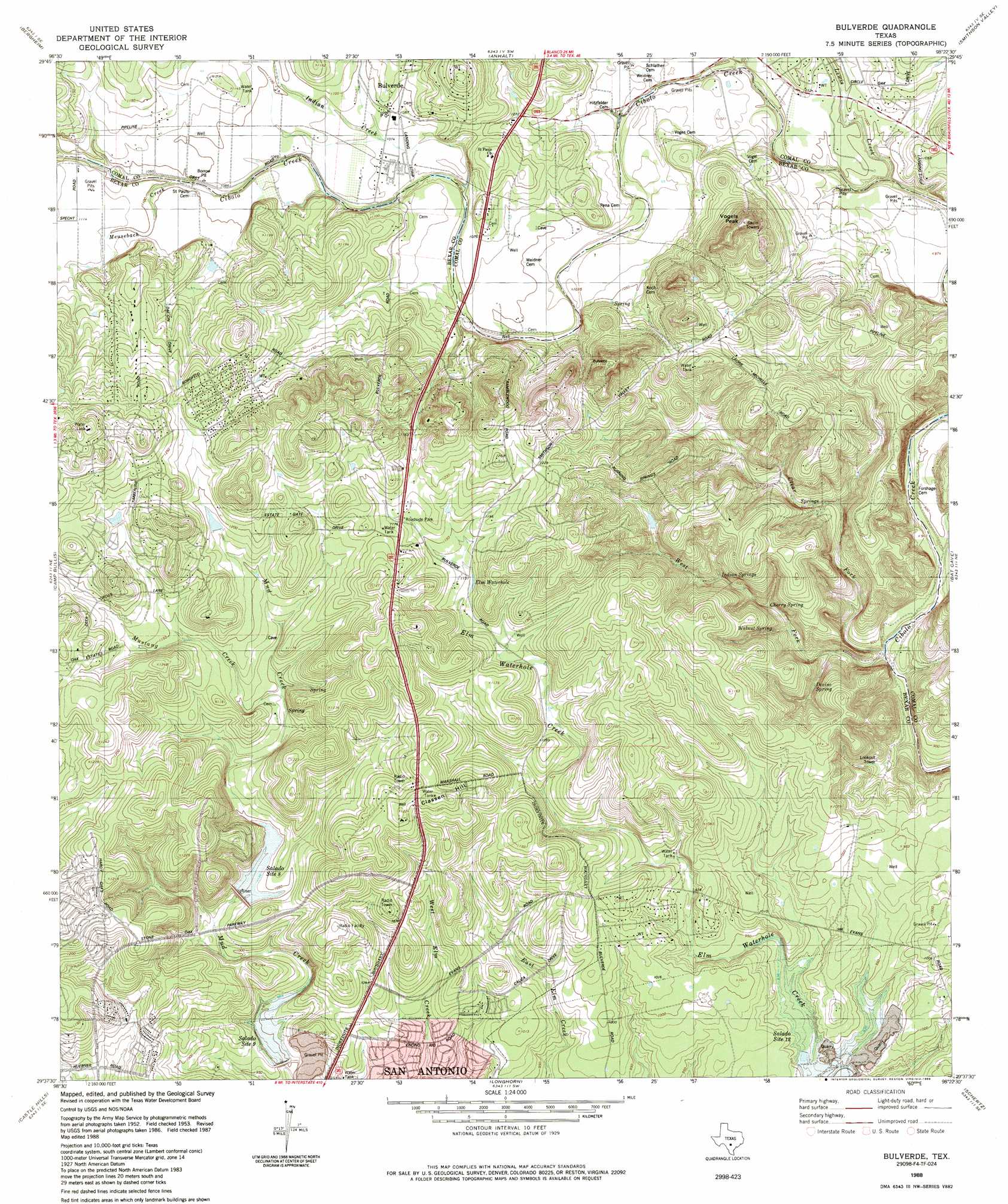
Bulverde Topo Map Texas
To zoom in, hover over the map of Bulverde
USGS Topo Quad 29098f4 - 1:24,000 scale
| Topo Map Name: | Bulverde |
| USGS Topo Quad ID: | 29098f4 |
| Print Size: | ca. 21 1/4" wide x 27" high |
| Southeast Coordinates: | 29.625° N latitude / 98.375° W longitude |
| Map Center Coordinates: | 29.6875° N latitude / 98.4375° W longitude |
| U.S. State: | TX |
| Filename: | o29098f4.jpg |
| Download Map JPG Image: | Bulverde topo map 1:24,000 scale |
| Map Type: | Topographic |
| Topo Series: | 7.5´ |
| Map Scale: | 1:24,000 |
| Source of Map Images: | United States Geological Survey (USGS) |
| Alternate Map Versions: |
Bulverde TX 1953, updated 1959 Download PDF Buy paper map Bulverde TX 1967, updated 1969 Download PDF Buy paper map Bulverde TX 1967, updated 1975 Download PDF Buy paper map Bulverde TX 1988, updated 1988 Download PDF Buy paper map Bulverde TX 2010 Download PDF Buy paper map Bulverde TX 2013 Download PDF Buy paper map Bulverde TX 2016 Download PDF Buy paper map |
1:24,000 Topo Quads surrounding Bulverde
Sisterdale |
Kendalia |
Spring Branch |
Fischer |
Devils Backbone |
Boerne |
Bergheim |
Anhalt |
Smithson Valley |
Sattler |
Van Raub |
Camp Bullis |
Bulverde |
Bat Cave |
New Braunfels West |
Helotes |
Castle Hills |
Longhorn |
Schertz |
Marion |
Culebra Hill |
San Antonio West |
San Antonio East |
Martinez |
Saint Hedwig |
> Back to 29098e1 at 1:100,000 scale
> Back to 29098a1 at 1:250,000 scale
> Back to U.S. Topo Maps home
Bulverde topo map: Gazetteer
Bulverde: Airports
Bulverde Airpark elevation 327m 1072′Flying J Airport elevation 319m 1046′
Bulverde: Arroyos
Kelly Creek elevation 331m 1085′Bulverde: Dams
Soil Conservation Service Site 12 Dam elevation 273m 895′Soil Conservation Service Site 8 Dam elevation 311m 1020′
Bulverde: Lakes
Elm Waterhole elevation 343m 1125′Bulverde: Populated Places
Bulverde elevation 333m 1092′Specht Store elevation 327m 1072′
Timberwood Park elevation 376m 1233′
Bulverde: Reservoirs
Soil Conservation Service Site 12 Reservoir elevation 273m 895′Soil Conservation Service Site 8 Reservoir elevation 311m 1020′
Bulverde: Springs
Cherry Spring elevation 293m 961′Devine Spring elevation 284m 931′
Indian Springs elevation 308m 1010′
Walnut Spring elevation 296m 971′
Bulverde: Streams
Clear Fork elevation 262m 859′Indian Creek elevation 320m 1049′
Lewis Creek elevation 292m 958′
Meusebach Creek elevation 328m 1076′
Mustang Creek elevation 331m 1085′
West Fork Cibolo Creek elevation 262m 859′
Bulverde: Summits
Classen Hill elevation 374m 1227′Vogels Peak elevation 414m 1358′
Bulverde digital topo map on disk
Buy this Bulverde topo map showing relief, roads, GPS coordinates and other geographical features, as a high-resolution digital map file on DVD: