Jack Mountain Topo Map Texas
To zoom in, hover over the map of Jack Mountain
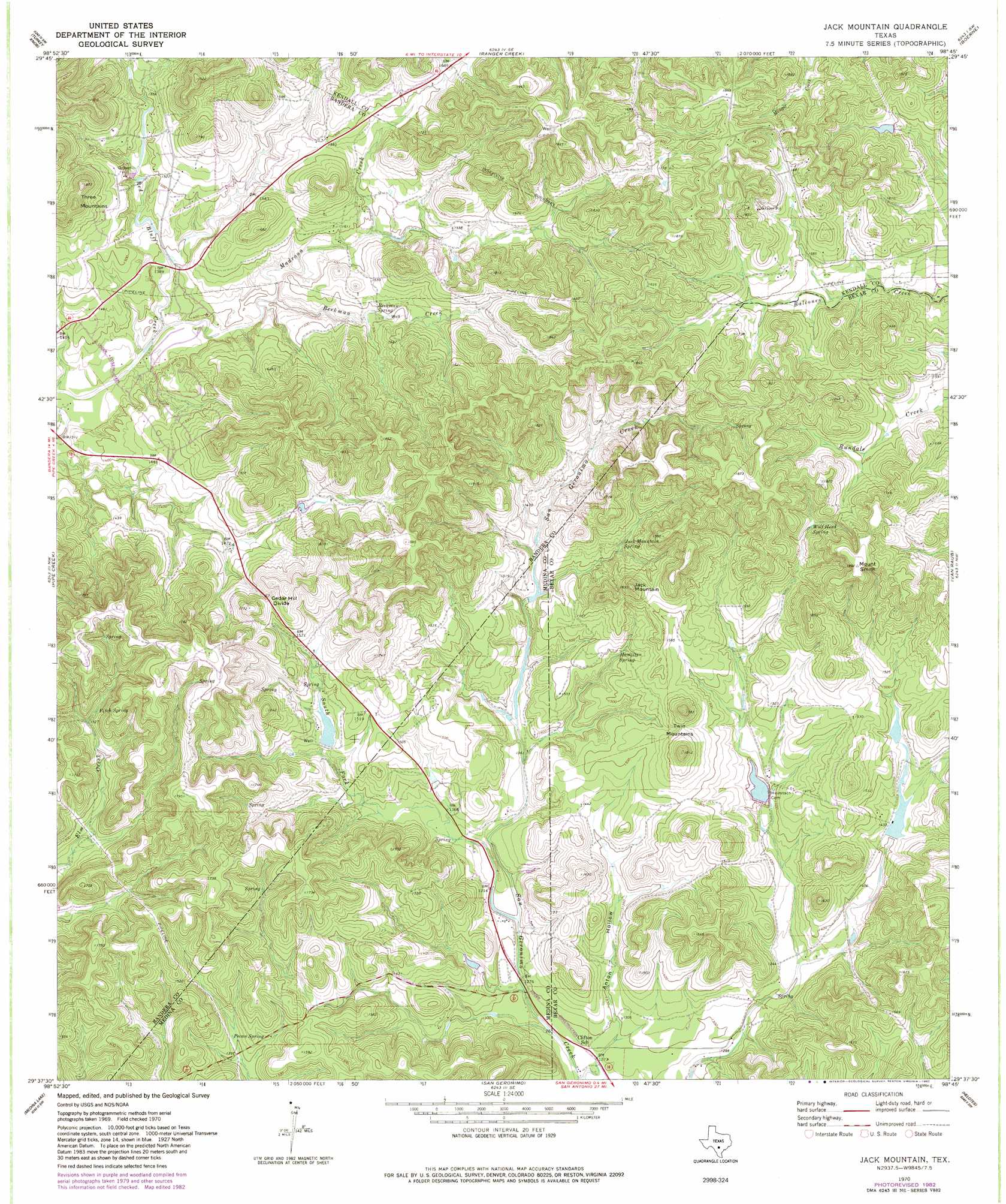
USGS Topo Quad 29098f7 - 1:24,000 scale
| Topo Map Name: | Jack Mountain |
| USGS Topo Quad ID: | 29098f7 |
| Print Size: | ca. 21 1/4" wide x 27" high |
| Southeast Coordinates: | 29.625° N latitude / 98.75° W longitude |
| Map Center Coordinates: | 29.6875° N latitude / 98.8125° W longitude |
| U.S. State: | TX |
| Filename: | o29098f7.jpg |
| Download Map JPG Image: | Jack Mountain topo map 1:24,000 scale |
| Map Type: | Topographic |
| Topo Series: | 7.5´ |
| Map Scale: | 1:24,000 |
| Source of Map Images: | United States Geological Survey (USGS) |
| Alternate Map Versions: |
Jack Mountain TX 1970, updated 1973 Download PDF Buy paper map Jack Mountain TX 1970, updated 1982 Download PDF Buy paper map Jack Mountain TX 2010 Download PDF Buy paper map Jack Mountain TX 2013 Download PDF Buy paper map Jack Mountain TX 2016 Download PDF Buy paper map |
1:24,000 Topo Quads surrounding Jack Mountain
Center Point |
Comfort |
Waring |
Sisterdale |
Kendalia |
Bandera Pass |
Turkey Knob |
Ranger Creek |
Boerne |
Bergheim |
Bandera |
Pipe Creek |
Jack Mountain |
Van Raub |
Camp Bullis |
Timber Creek |
Medina Lake |
San Geronimo |
Helotes |
Castle Hills |
Quihi |
Riomedina |
Lacoste Ne |
Culebra Hill |
San Antonio West |
> Back to 29098e1 at 1:100,000 scale
> Back to 29098a1 at 1:250,000 scale
> Back to U.S. Topo Maps home
Jack Mountain topo map: Gazetteer
Jack Mountain: Airports
Freedom Springs Ranch Airport elevation 417m 1368′Jack Mountain: Dams
Heimsath Cemetery Lake Dam elevation 422m 1384′Walton Lake Dam elevation 445m 1459′
White Lake Dam elevation 433m 1420′
White Ranch Lake Dam elevation 451m 1479′
Jack Mountain: Gaps
Cedar Hill Divide elevation 498m 1633′Jack Mountain: Reservoirs
Heimsath Cemetery Lake elevation 422m 1384′Walton Lake elevation 445m 1459′
White Lake elevation 433m 1420′
White Ranch Lake elevation 451m 1479′
Jack Mountain: Springs
Beekman Spring elevation 451m 1479′Fitch Spring elevation 473m 1551′
Hamilton Spring elevation 447m 1466′
Jack Mountain Spring elevation 466m 1528′
Pecan Spring elevation 428m 1404′
Wolf Head Spring elevation 489m 1604′
Jack Mountain: Streams
Beekman Creek elevation 422m 1384′Madrona Creek elevation 408m 1338′
South Fork Sangeronimo Creek elevation 402m 1318′
Jack Mountain: Summits
Jack Mountain elevation 557m 1827′Mount Smith elevation 578m 1896′
Three Mountains elevation 566m 1856′
Twin Mountains elevation 546m 1791′
Jack Mountain: Valleys
Anton Hollow elevation 395m 1295′Jack Mountain digital topo map on disk
Buy this Jack Mountain topo map showing relief, roads, GPS coordinates and other geographical features, as a high-resolution digital map file on DVD: