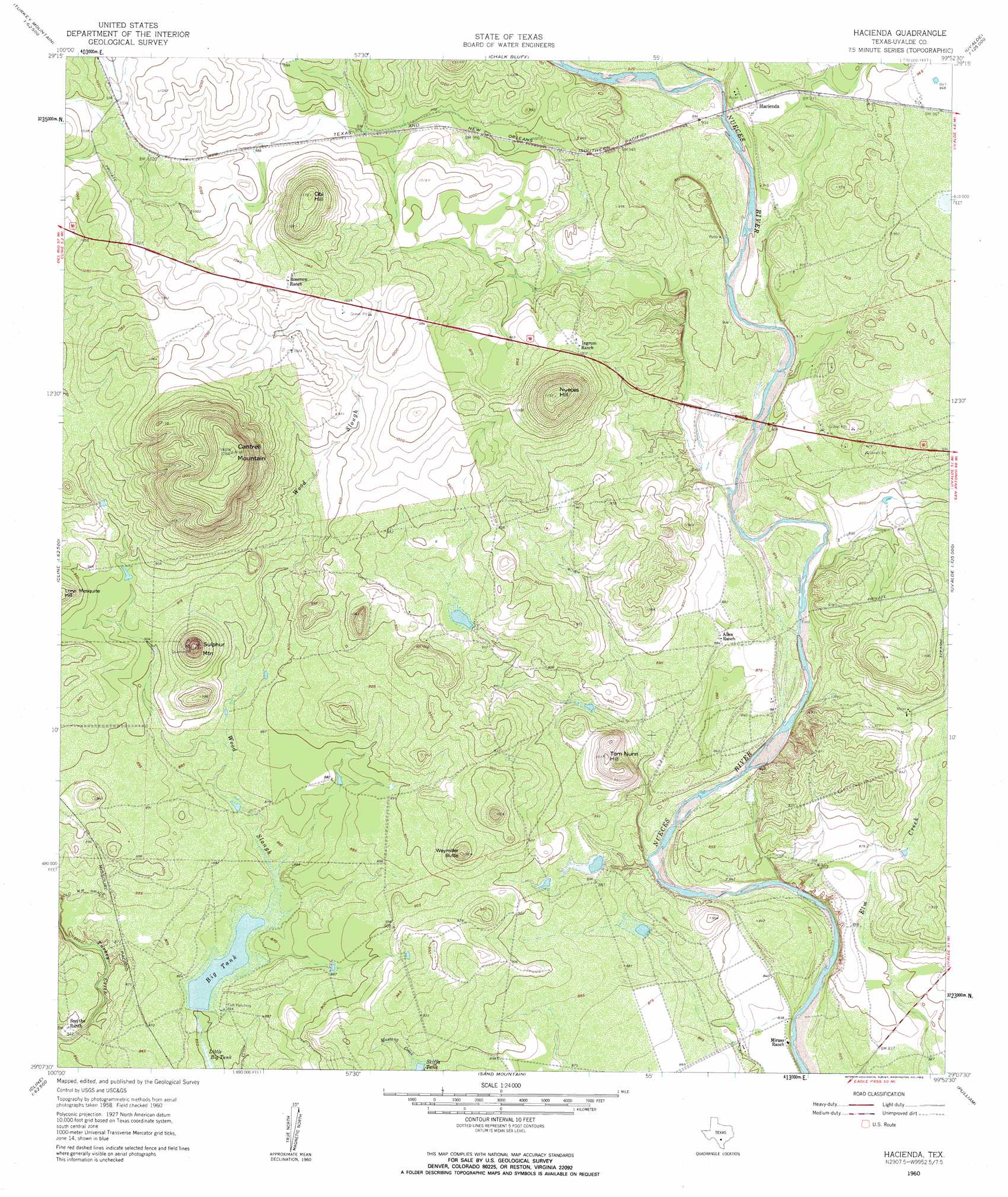
Hacienda Topo Map Texas
To zoom in, hover over the map of Hacienda
USGS Topo Quad 29099b8 - 1:24,000 scale
| Topo Map Name: | Hacienda |
| USGS Topo Quad ID: | 29099b8 |
| Print Size: | ca. 21 1/4" wide x 27" high |
| Southeast Coordinates: | 29.125° N latitude / 99.875° W longitude |
| Map Center Coordinates: | 29.1875° N latitude / 99.9375° W longitude |
| U.S. State: | TX |
| Filename: | o29099b8.jpg |
| Download Map JPG Image: | Hacienda topo map 1:24,000 scale |
| Map Type: | Topographic |
| Topo Series: | 7.5´ |
| Map Scale: | 1:24,000 |
| Source of Map Images: | United States Geological Survey (USGS) |
| Alternate Map Versions: |
Hacienda TX 1960, updated 1962 Download PDF Buy paper map Hacienda TX 1960, updated 1962 Download PDF Buy paper map Hacienda TX 2010 Download PDF Buy paper map Hacienda TX 2013 Download PDF Buy paper map Hacienda TX 2016 Download PDF Buy paper map |
1:24,000 Topo Quads surrounding Hacienda
Salmon Peak |
Laguna |
Sycamore Mountain |
Deep Creek |
Concan |
Turkey Mountain |
Mustang Waterhole |
Chalk Bluff |
Sevenmile Hill |
Knippa |
Odlaw |
Cline |
Hacienda |
Uvalde |
Garner Field |
Goofy Lake |
Olmos Creek |
Sand Mountain |
Pulliam Ranch |
Batesville Hill |
Chacon Creek Nw |
Chacon Creek Ne |
La Pryor Nw |
La Pryor |
Batesville Nw |
> Back to 29099a1 at 1:100,000 scale
> Back to 29098a1 at 1:250,000 scale
> Back to U.S. Topo Maps home
Hacienda topo map: Gazetteer
Hacienda: Bridges
State Highway 3 Bridge elevation 268m 879′Hacienda: Dams
Smyth Dam elevation 259m 849′Thompson Tank Dam elevation 268m 879′
Hacienda: Reservoirs
Big Tank elevation 263m 862′Skiffa Tank elevation 274m 898′
Thompson Tank Reservoir elevation 268m 879′
Hacienda: Springs
Soldiers Camp Springs elevation 265m 869′Hacienda: Summits
Cantrell Mountain elevation 391m 1282′Nueces Hill elevation 360m 1181′
Obi Hill elevation 358m 1174′
Sulphur Mountain elevation 335m 1099′
Tom Nunn Hill elevation 307m 1007′
Weymiller Butte elevation 305m 1000′
Hacienda digital topo map on disk
Buy this Hacienda topo map showing relief, roads, GPS coordinates and other geographical features, as a high-resolution digital map file on DVD: