Tarpley Pass Topo Map Texas
To zoom in, hover over the map of Tarpley Pass
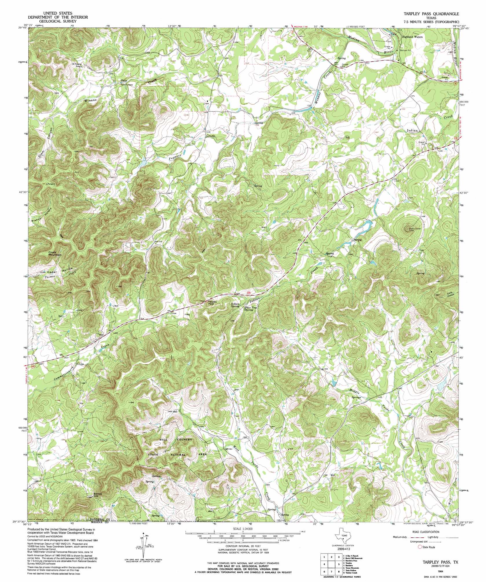
USGS Topo Quad 29099f2 - 1:24,000 scale
| Topo Map Name: | Tarpley Pass |
| USGS Topo Quad ID: | 29099f2 |
| Print Size: | ca. 21 1/4" wide x 27" high |
| Southeast Coordinates: | 29.625° N latitude / 99.125° W longitude |
| Map Center Coordinates: | 29.6875° N latitude / 99.1875° W longitude |
| U.S. State: | TX |
| Filename: | o29099f2.jpg |
| Download Map JPG Image: | Tarpley Pass topo map 1:24,000 scale |
| Map Type: | Topographic |
| Topo Series: | 7.5´ |
| Map Scale: | 1:24,000 |
| Source of Map Images: | United States Geological Survey (USGS) |
| Alternate Map Versions: |
Tarpley Pass TX 1964, updated 1968 Download PDF Buy paper map Tarpley Pass TX 1964, updated 1968 Download PDF Buy paper map Tarpley Pass TX 1964, updated 1995 Download PDF Buy paper map Tarpley Pass TX 2010 Download PDF Buy paper map Tarpley Pass TX 2013 Download PDF Buy paper map Tarpley Pass TX 2016 Download PDF Buy paper map |
1:24,000 Topo Quads surrounding Tarpley Pass
Diamond S Ranch |
Echo Hill Ranch |
Fall Creek |
Center Point |
Comfort |
Love Creek |
A Bar A Ranch |
Rock Cliff Reservoir |
Bandera Pass |
Turkey Knob |
Seco Pass |
Tarpley |
Tarpley Pass |
Bandera |
Pipe Creek |
Flatrock Crossing |
Texas Mountain |
Twin Hollow |
Timber Creek |
Medina Lake |
Comanche Waterhole |
Sabinal Ne |
Mustang Valley |
Quihi |
Riomedina |
> Back to 29099e1 at 1:100,000 scale
> Back to 29098a1 at 1:250,000 scale
> Back to U.S. Topo Maps home
Tarpley Pass topo map: Gazetteer
Tarpley Pass: Cliffs
Lovers Leap elevation 450m 1476′Tarpley Pass: Dams
Middle Verde Ranch Lake Dam elevation 454m 1489′Tarpley Pass: Gaps
Barnes Gap elevation 485m 1591′Tarpley Pass elevation 527m 1729′
Tarpley Pass: Parks
Hill Country State Natural Area elevation 475m 1558′Tarpley Pass: Reservoirs
Middle Verde Ranch Lake elevation 454m 1489′Tarpley Pass: Springs
Indian Spring elevation 485m 1591′Pear Tree Spring elevation 487m 1597′
Tarpley Pass: Streams
Hicks Creek elevation 395m 1295′Pugmore Creek elevation 414m 1358′
Winans Creek elevation 395m 1295′
Wolf Creek elevation 396m 1299′
Tarpley Pass: Summits
Chalk Mountain elevation 601m 1971′Tarpley Pass: Trails
Hill Country State Natural Area Trail elevation 522m 1712′Tarpley Pass: Valleys
Cedar Hollow elevation 455m 1492′Elam Canyon elevation 469m 1538′
Tarpley Pass digital topo map on disk
Buy this Tarpley Pass topo map showing relief, roads, GPS coordinates and other geographical features, as a high-resolution digital map file on DVD: