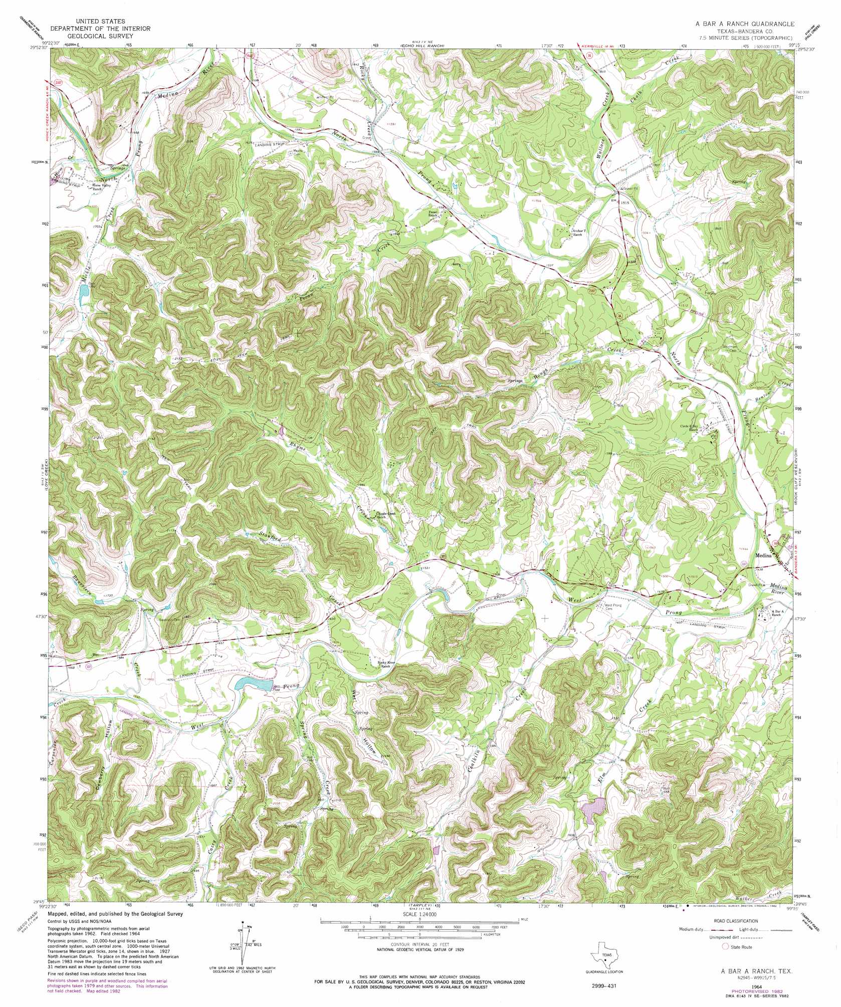
A Bar A Ranch Topo Map Texas
To zoom in, hover over the map of A Bar A Ranch
USGS Topo Quad 29099g3 - 1:24,000 scale
| Topo Map Name: | A Bar A Ranch |
| USGS Topo Quad ID: | 29099g3 |
| Print Size: | ca. 21 1/4" wide x 27" high |
| Southeast Coordinates: | 29.75° N latitude / 99.25° W longitude |
| Map Center Coordinates: | 29.8125° N latitude / 99.3125° W longitude |
| U.S. State: | TX |
| Filename: | o29099g3.jpg |
| Download Map JPG Image: | A Bar A Ranch topo map 1:24,000 scale |
| Map Type: | Topographic |
| Topo Series: | 7.5´ |
| Map Scale: | 1:24,000 |
| Source of Map Images: | United States Geological Survey (USGS) |
| Alternate Map Versions: |
A Bar A Ranch TX 1964, updated 1967 Download PDF Buy paper map A Bar A Ranch TX 1964, updated 1982 Download PDF Buy paper map A Bar A Ranch TX 2010 Download PDF Buy paper map A Bar A Ranch TX 2013 Download PDF Buy paper map A Bar A Ranch TX 2016 Download PDF Buy paper map |
1:24,000 Topo Quads surrounding A Bar A Ranch
Boneyard Draw |
Bee Caves Creek |
Hunt |
Kerrville |
Legion |
Well Hollow |
Diamond S Ranch |
Echo Hill Ranch |
Fall Creek |
Center Point |
Sabinal Canyon |
Love Creek |
A Bar A Ranch |
Rock Cliff Reservoir |
Bandera Pass |
Vanderpool |
Seco Pass |
Tarpley |
Tarpley Pass |
Bandera |
Utopia |
Flatrock Crossing |
Texas Mountain |
Twin Hollow |
Timber Creek |
> Back to 29099e1 at 1:100,000 scale
> Back to 29098a1 at 1:250,000 scale
> Back to U.S. Topo Maps home
A Bar A Ranch topo map: Gazetteer
A Bar A Ranch: Airports
Cinco B Ranch Airport elevation 446m 1463′Circle R Resort Ranch Airport elevation 449m 1473′
Idlewild Airport elevation 509m 1669′
A Bar A Ranch: Dams
Gallant Lake Dam elevation 485m 1591′Garrison Lake Dam elevation 481m 1578′
Thompson Lake Dam elevation 534m 1751′
A Bar A Ranch: Reservoirs
Gallant Lake elevation 485m 1591′Garrison Lake elevation 481m 1578′
Thompson Lake elevation 534m 1751′
A Bar A Ranch: Streams
Bauerlein Creek elevation 495m 1624′Benton Creek elevation 442m 1450′
Carpenter Creek elevation 499m 1637′
Cazey Creek elevation 487m 1597′
Chalk Creek elevation 470m 1541′
Coalkiln Creek elevation 444m 1456′
Elm Creek elevation 438m 1437′
Horse Creek elevation 501m 1643′
Hough Creek elevation 458m 1502′
Mickle Creek elevation 506m 1660′
North Prong Medina River elevation 433m 1420′
Pecan Creek elevation 471m 1545′
Rhyme Creek elevation 457m 1499′
Rocky Creek elevation 475m 1558′
Spring Creek elevation 489m 1604′
Stanford Creek elevation 464m 1522′
Wallace Creek elevation 457m 1499′
West Prong Medina River elevation 433m 1420′
A Bar A Ranch: Valleys
Dewberry Hollow elevation 495m 1624′Wet Hollow elevation 467m 1532′
A Bar A Ranch digital topo map on disk
Buy this A Bar A Ranch topo map showing relief, roads, GPS coordinates and other geographical features, as a high-resolution digital map file on DVD: