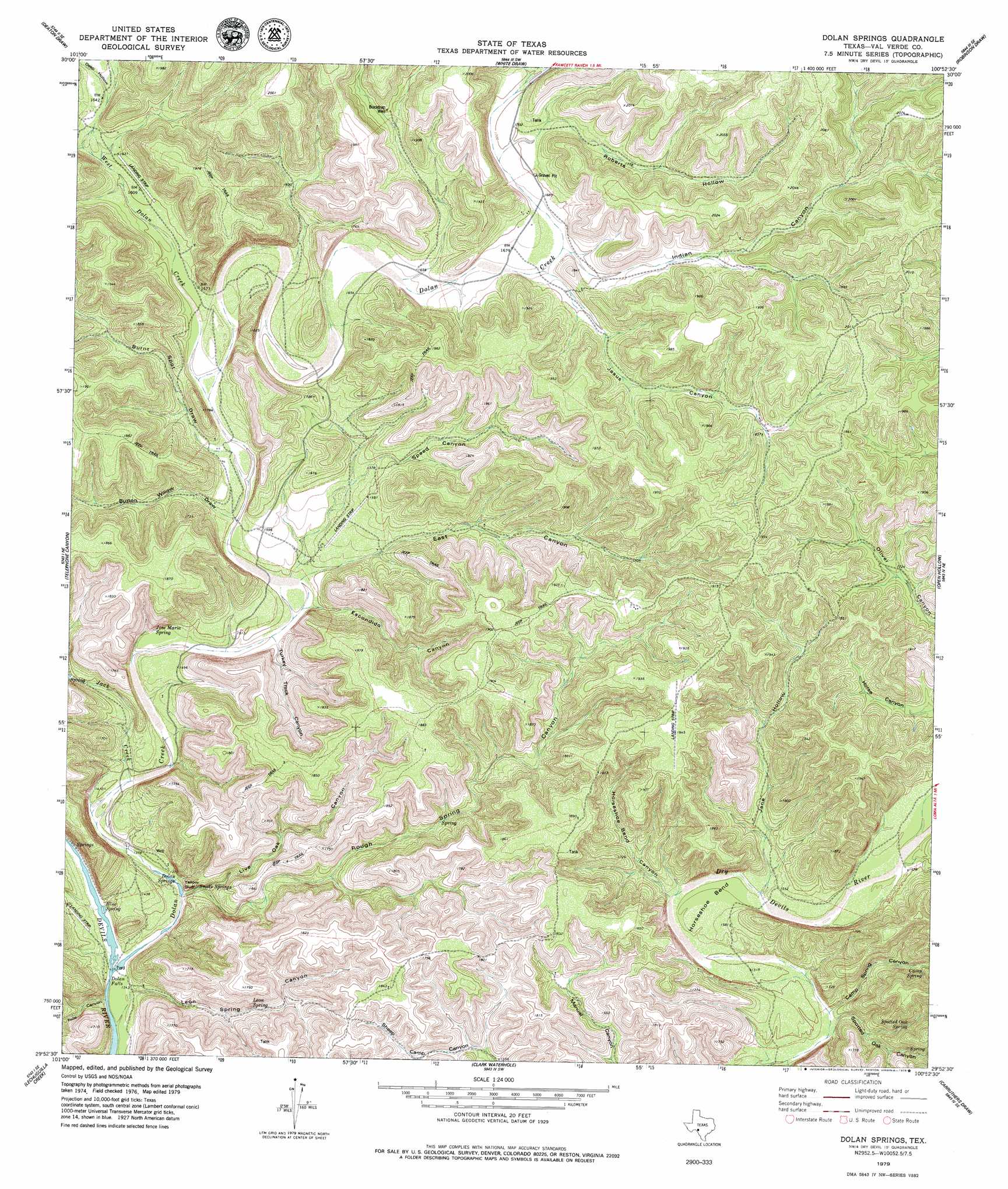
Dolan Springs Topo Map Texas
To zoom in, hover over the map of Dolan Springs
USGS Topo Quad 29100h8 - 1:24,000 scale
| Topo Map Name: | Dolan Springs |
| USGS Topo Quad ID: | 29100h8 |
| Print Size: | ca. 21 1/4" wide x 27" high |
| Southeast Coordinates: | 29.875° N latitude / 100.875° W longitude |
| Map Center Coordinates: | 29.9375° N latitude / 100.9375° W longitude |
| U.S. State: | TX |
| Filename: | o29100h8.jpg |
| Download Map JPG Image: | Dolan Springs topo map 1:24,000 scale |
| Map Type: | Topographic |
| Topo Series: | 7.5´ |
| Map Scale: | 1:24,000 |
| Source of Map Images: | United States Geological Survey (USGS) |
| Alternate Map Versions: |
Dolan Springs TX 1979, updated 1979 Download PDF Buy paper map Dolan Springs TX 2010 Download PDF Buy paper map Dolan Springs TX 2013 Download PDF Buy paper map Dolan Springs TX 2016 Download PDF Buy paper map |
1:24,000 Topo Quads surrounding Dolan Springs
Bee Canyon |
Juno |
White Draw Nw |
White Draw Ne |
Turney Draw Nw |
Sycamore Canyon |
Deaton Draw |
White Draw |
Robinson Draw |
Four Mills |
Bakers Crossing |
Telephone Canyon |
Dolan Springs |
Open Hollow |
Holcomb Draw |
Dead Mans Pass |
Lechuguilla Creek |
Clark Waterhole |
Carruthers Draw |
Carta Valley |
Comstock |
Gillis Ranch |
Satan Canyon |
Miers Ranch |
Flat Rock Creek Nw |
> Back to 29100e1 at 1:100,000 scale
> Back to 29100a1 at 1:250,000 scale
> Back to U.S. Topo Maps home
Dolan Springs topo map: Gazetteer
Dolan Springs: Airports
Rnk Ranch Airport elevation 594m 1948′Dolan Springs: Bends
Horseshoe Bend elevation 468m 1535′Dolan Springs: Cliffs
Yellow Bluff elevation 442m 1450′Dolan Springs: Falls
Dolan Falls elevation 403m 1322′Dolan Springs: Parks
Devils River State Natural Area elevation 575m 1886′Dolan Springs: Springs
Blue Spring elevation 409m 1341′Camp Spring elevation 498m 1633′
Dolan Springs elevation 412m 1351′
Jose Maria Spring elevation 439m 1440′
Leon Spring elevation 440m 1443′
Snake Springs elevation 410m 1345′
Spotted Oak Spring elevation 494m 1620′
Dolan Springs: Streams
Dolan Creek elevation 405m 1328′Jack Creek elevation 424m 1391′
West Dolan Creek elevation 474m 1555′
Dolan Springs: Valleys
Burnt Spot Draw elevation 466m 1528′Button Willow Draw elevation 461m 1512′
Camp Spring Canyon elevation 453m 1486′
Deep Hollow elevation 499m 1637′
East Canyon elevation 458m 1502′
Escondido Canyon elevation 452m 1482′
Falls Canyon elevation 402m 1318′
Horseshoe Bend Canyon elevation 462m 1515′
Indian Canyon elevation 514m 1686′
Jane Hollow elevation 468m 1535′
Jesus Canyon elevation 516m 1692′
Leon Spring Canyon elevation 408m 1338′
Live Oak Canyon elevation 442m 1450′
Live Oak Draw elevation 493m 1617′
Roberts Hollow elevation 524m 1719′
Rough Spring Canyon elevation 415m 1361′
Speed Canyon elevation 479m 1571′
Spotted Oak Canyon elevation 459m 1505′
Tom and Henry Canyon elevation 481m 1578′
Turkey Track Canyon elevation 452m 1482′
Dolan Springs: Wells
Bucktrap Well elevation 533m 1748′Dolan Springs digital topo map on disk
Buy this Dolan Springs topo map showing relief, roads, GPS coordinates and other geographical features, as a high-resolution digital map file on DVD: