Gillis Ranch Topo Map Texas
To zoom in, hover over the map of Gillis Ranch
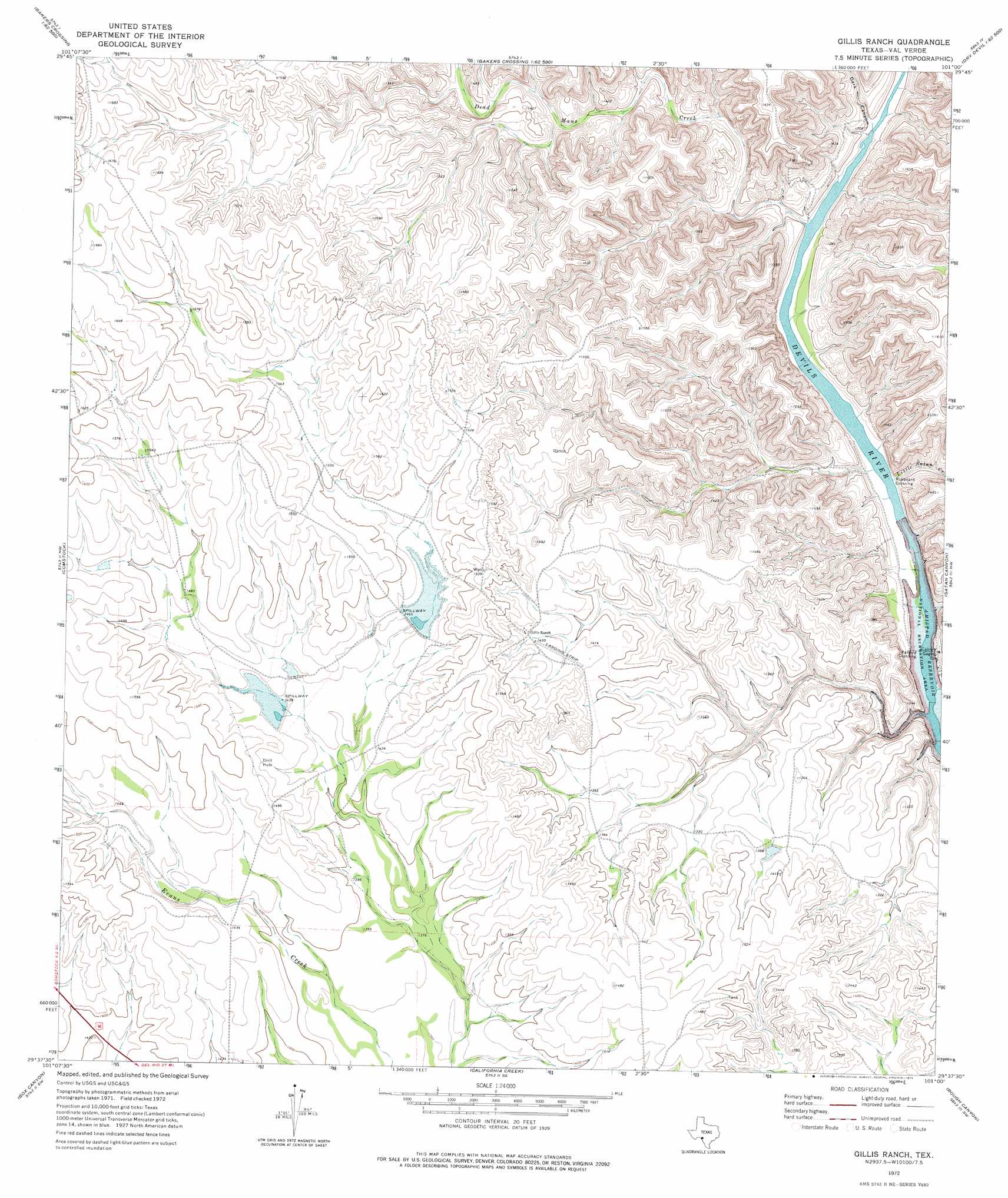
USGS Topo Quad 29101f1 - 1:24,000 scale
| Topo Map Name: | Gillis Ranch |
| USGS Topo Quad ID: | 29101f1 |
| Print Size: | ca. 21 1/4" wide x 27" high |
| Southeast Coordinates: | 29.625° N latitude / 101° W longitude |
| Map Center Coordinates: | 29.6875° N latitude / 101.0625° W longitude |
| U.S. State: | TX |
| Filename: | o29101f1.jpg |
| Download Map JPG Image: | Gillis Ranch topo map 1:24,000 scale |
| Map Type: | Topographic |
| Topo Series: | 7.5´ |
| Map Scale: | 1:24,000 |
| Source of Map Images: | United States Geological Survey (USGS) |
| Alternate Map Versions: |
Gillis Ranch TX 1972, updated 1975 Download PDF Buy paper map Gillis Ranch TX 2010 Download PDF Buy paper map Gillis Ranch TX 2013 Download PDF Buy paper map Gillis Ranch TX 2016 Download PDF Buy paper map |
1:24,000 Topo Quads surrounding Gillis Ranch
Mayfield Canyon |
Bakers Crossing |
Telephone Canyon |
Dolan Springs |
Open Hollow |
Pecos High Bridge |
Dead Mans Pass |
Lechuguilla Creek |
Clark Waterhole |
Carruthers Draw |
Seminole Canyon |
Comstock |
Gillis Ranch |
Satan Canyon |
Miers Ranch |
Zuberbueler Bend |
Box Canyon |
California Creek |
Rough Canyon |
Rough Canyon Se |
Amistad Dam |
Del Rio Nw |
Del Rio Ne |
> Back to 29101e1 at 1:100,000 scale
> Back to 29100a1 at 1:250,000 scale
> Back to U.S. Topo Maps home
Gillis Ranch topo map: Gazetteer
Gillis Ranch: Dams
Gillis East Lake Dam elevation 452m 1482′Gillis West Lake Dam elevation 433m 1420′
Gillis Ranch: Populated Places
Rubboard Crossing elevation 353m 1158′Gillis Ranch: Reservoirs
Gillis East Lake elevation 452m 1482′Gillis West Lake elevation 433m 1420′
Gillis Ranch: Springs
Gillis Springs elevation 427m 1400′Gillis Ranch: Streams
Dead Mans Creek elevation 359m 1177′Little Satan Creek elevation 350m 1148′
Gillis Ranch: Valleys
Dark Canyon elevation 364m 1194′Gillis Ranch digital topo map on disk
Buy this Gillis Ranch topo map showing relief, roads, GPS coordinates and other geographical features, as a high-resolution digital map file on DVD: