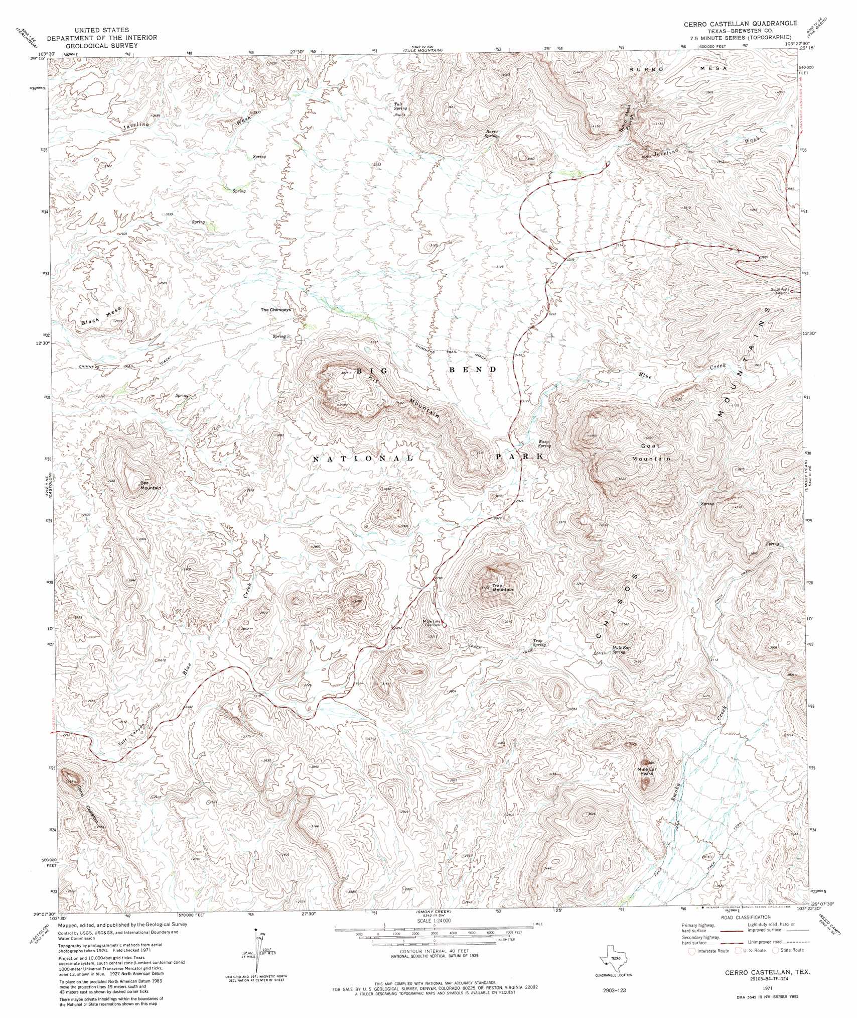
Cerro Castellan Topo Map Texas
To zoom in, hover over the map of Cerro Castellan
USGS Topo Quad 29103b4 - 1:24,000 scale
| Topo Map Name: | Cerro Castellan |
| USGS Topo Quad ID: | 29103b4 |
| Print Size: | ca. 21 1/4" wide x 27" high |
| Southeast Coordinates: | 29.125° N latitude / 103.375° W longitude |
| Map Center Coordinates: | 29.1875° N latitude / 103.4375° W longitude |
| U.S. State: | TX |
| Filename: | o29103b4.jpg |
| Download Map JPG Image: | Cerro Castellan topo map 1:24,000 scale |
| Map Type: | Topographic |
| Topo Series: | 7.5´ |
| Map Scale: | 1:24,000 |
| Source of Map Images: | United States Geological Survey (USGS) |
| Alternate Map Versions: |
Cerro Castellan TX 1971, updated 1973 Download PDF Buy paper map Cerro Castellan TX 1971, updated 1980 Download PDF Buy paper map Cerro Castellan TX 1971, updated 1985 Download PDF Buy paper map Cerro Castellan TX 1971, updated 1985 Download PDF Buy paper map Cerro Castellan TX 2010 Download PDF Buy paper map Cerro Castellan TX 2012 Download PDF Buy paper map Cerro Castellan TX 2016 Download PDF Buy paper map |
1:24,000 Topo Quads surrounding Cerro Castellan
Yellow Hill |
Hen Egg Mountain |
Christmas Mountains |
Sombero Peak |
Grapevine Hills |
Amarilla Mountain |
Terlingua |
Tule Mountain |
The Basin |
Panther Junction |
Mesa De Anguila |
Castolon |
Cerro Castellan |
Emory Peak |
Glenn Spring |
Smoky Creek |
Reed Camp |
Mariscal Mountain |
||
> Back to 29103a1 at 1:100,000 scale
> Back to 29102a1 at 1:250,000 scale
> Back to U.S. Topo Maps home
Cerro Castellan topo map: Gazetteer
Cerro Castellan: Arches
Burro Mesa Pouroff Window elevation 1100m 3608′Cerro Castellan: Pillars
The Chimneys elevation 854m 2801′Cerro Castellan: Springs
Burro Spring elevation 994m 3261′Mule Ear Spring elevation 935m 3067′
Trap Spring elevation 875m 2870′
Tule Spring elevation 892m 2926′
Cerro Castellan: Summits
Bee Mountain elevation 993m 3257′Black Mesa elevation 834m 2736′
Burro Mesa elevation 1315m 4314′
Cerro Castellan elevation 998m 3274′
Goat Mountain elevation 1395m 4576′
Kit Mountain elevation 1146m 3759′
Mule Ear Peaks elevation 1044m 3425′
Trap Mountain elevation 1243m 4078′
Cerro Castellan: Trails
Burro Mesa Pouroff Trail elevation 1043m 3421′Burro Mesa Spring Trail elevation 976m 3202′
Chimneys Trail elevation 965m 3166′
Chimneys Trail elevation 827m 2713′
Mule Ears - Smoky Creek Trail elevation 884m 2900′
Tuff Canyon Trail elevation 721m 2365′
Cerro Castellan: Valleys
Burro Mesa Pouroff elevation 1012m 3320′Tuff Canyon elevation 702m 2303′
Cerro Castellan digital topo map on disk
Buy this Cerro Castellan topo map showing relief, roads, GPS coordinates and other geographical features, as a high-resolution digital map file on DVD: