Jacksonville Heights Topo Map Florida
To zoom in, hover over the map of Jacksonville Heights
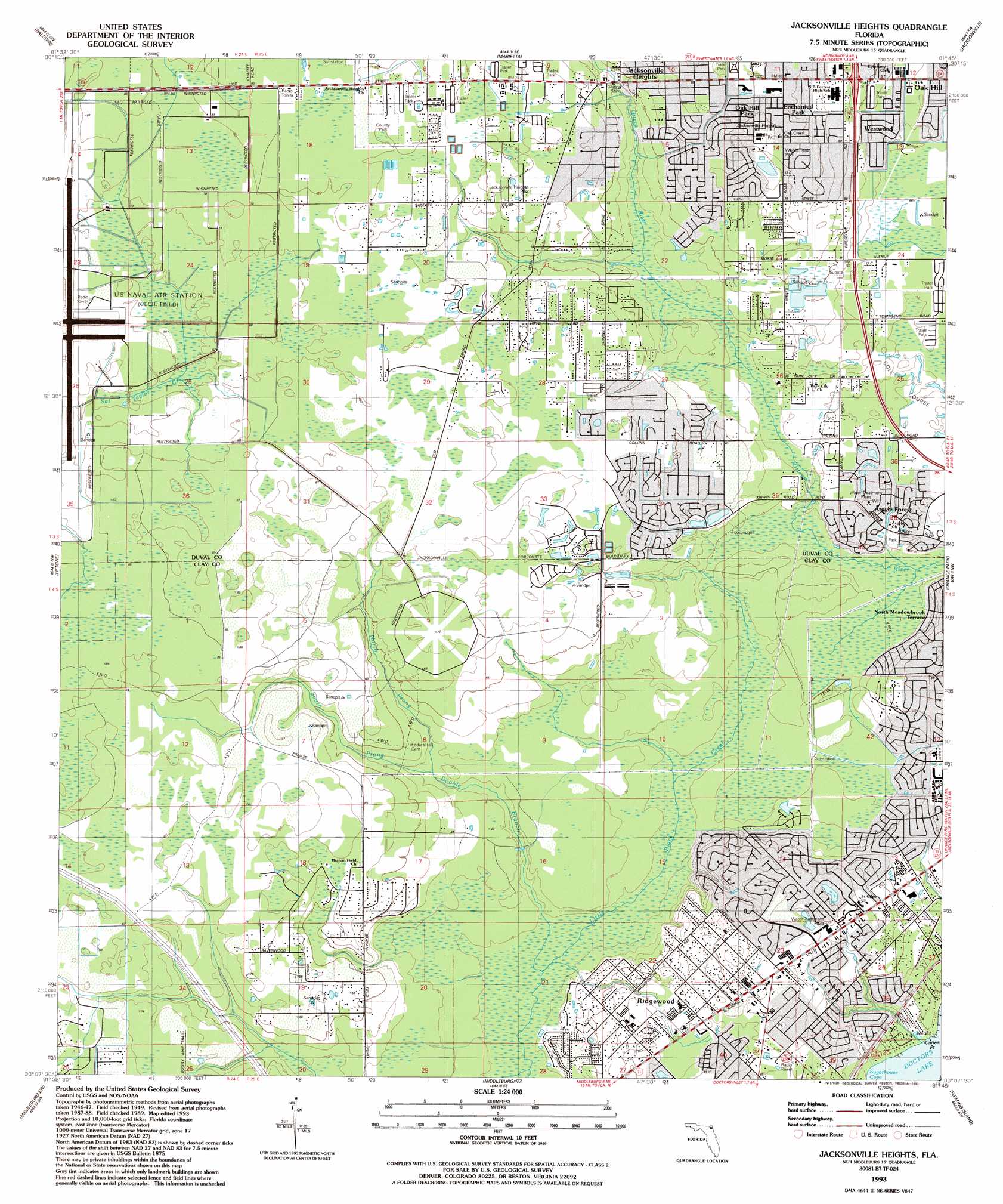
USGS Topo Quad 30081b7 - 1:24,000 scale
| Topo Map Name: | Jacksonville Heights |
| USGS Topo Quad ID: | 30081b7 |
| Print Size: | ca. 21 1/4" wide x 27" high |
| Southeast Coordinates: | 30.125° N latitude / 81.75° W longitude |
| Map Center Coordinates: | 30.1875° N latitude / 81.8125° W longitude |
| U.S. State: | FL |
| Filename: | O30081B7.jpg |
| Download Map JPG Image: | Jacksonville Heights topo map 1:24,000 scale |
| Map Type: | Topographic |
| Topo Series: | 7.5´ |
| Map Scale: | 1:24,000 |
| Source of Map Images: | United States Geological Survey (USGS) |
| Alternate Map Versions: |
Jacksonville Heights FL 1949, updated 1953 Download PDF Buy paper map Jacksonville Heights FL 1964, updated 1965 Download PDF Buy paper map Jacksonville Heights FL 1964, updated 1972 Download PDF Buy paper map Jacksonville Heights FL 1964, updated 1990 Download PDF Buy paper map Jacksonville Heights FL 1993, updated 1993 Download PDF Buy paper map Jacksonville Heights FL 1993, updated 1993 Download PDF Buy paper map Jacksonville Heights FL 1994, updated 2002 Download PDF Buy paper map Jacksonville Heights FL 2012 Download PDF Buy paper map Jacksonville Heights FL 2015 Download PDF Buy paper map |
1:24,000 Topo Quads surrounding Jacksonville Heights
Macclenny Ne |
Bryceville |
Dinsmore |
Trout River |
Eastport |
Macclenny East |
Baldwin |
Marietta |
Jacksonville |
Arlington |
Maxville |
Fiftone |
Jacksonville Heights |
Orange Park |
Bayard |
Lawtey |
Middleburg Sw |
Middleburg |
Fleming Island |
Orangedale |
Starke |
Kingsley |
Penney Farms |
Green Cove Springs |
Picolata |
> Back to 30081a1 at 1:100,000 scale
> Back to 30080a1 at 1:250,000 scale
> Back to U.S. Topo Maps home
Jacksonville Heights topo map: Gazetteer
Jacksonville Heights: Bays
Sugarhouse Cove elevation 0m 0′Jacksonville Heights: Crossings
Interchange 16 elevation 30m 98′Jacksonville Heights: Forests
Jennings State Forest elevation 24m 78′Jacksonville Heights: Parks
Branan Field Mitigation Park Wildlife and Environmental Area elevation 27m 88′Jacksonville Heights Park elevation 22m 72′
Miniature Acres Park elevation 23m 75′
Oak Grove Park elevation 6m 19′
Wheat Field Park elevation 27m 88′
Jacksonville Heights: Populated Places
Argyle Forest elevation 5m 16′Arrow Lane Mobile Home Park elevation 24m 78′
Carr Mobile Home Village elevation 20m 65′
Circle Eleven Mobile Home Park elevation 24m 78′
Connie Jean Mobile Home Park elevation 24m 78′
Country Roads Mobile Home Community elevation 6m 19′
Crystal Oaks Mobile Home Park elevation 18m 59′
Enchanted Park elevation 23m 75′
Hewitt Street Mobile Home Park elevation 25m 82′
Jamestown Estates Mobile Home Park elevation 6m 19′
Lakeside elevation 20m 65′
North Meadowbrook Terrace elevation 16m 52′
Oak Hill elevation 9m 29′
Oak Hill Park elevation 26m 85′
Oak Ridge Mobile Home Village elevation 19m 62′
Park Ridge Mobile Home Park elevation 22m 72′
Pine Breeze Mobile Home Park elevation 24m 78′
Ridgewood elevation 26m 85′
Shawn Lane Mobile Home Park elevation 12m 39′
Sunny Acres Mobile Home Park elevation 24m 78′
Town and Country Mobile Home Park elevation 18m 59′
Westport Mobile Home Park elevation 13m 42′
Westwood elevation 12m 39′
Whispering Pines Trailer Park elevation 21m 68′
Jacksonville Heights: Reservoirs
Doctors Lake elevation 0m 0′Jacksonville Heights: Streams
Double Branch elevation 3m 9′North Prong Double Branch elevation 8m 26′
South Prong Double Branch elevation 7m 22′
Jacksonville Heights digital topo map on disk
Buy this Jacksonville Heights topo map showing relief, roads, GPS coordinates and other geographical features, as a high-resolution digital map file on DVD: