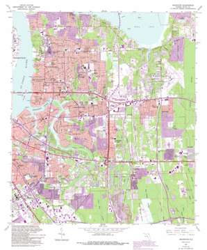
Arlington Topo Map Florida
To zoom in, hover over the map of Arlington
USGS Topo Quad 30081c5 - 1:24,000 scale
| Topo Map Name: | Arlington |
| USGS Topo Quad ID: | 30081c5 |
| Print Size: | ca. 21 1/4" wide x 27" high |
| Southeast Coordinates: | 30.25° N latitude / 81.5° W longitude |
| Map Center Coordinates: | 30.3125° N latitude / 81.5625° W longitude |
| U.S. State: | FL |
| Filename: | O30081C5.jpg |
| Download Map JPG Image: | Arlington topo map 1:24,000 scale |
| Map Type: | Topographic |
| Topo Series: | 7.5´ |
| Map Scale: | 1:24,000 |
| Source of Map Images: | United States Geological Survey (USGS) |
| Alternate Map Versions: |
Arlington FL 1950 Download PDF Buy paper map Arlington FL 1963, updated 1965 Download PDF Buy paper map Arlington FL 1963, updated 1972 Download PDF Buy paper map Arlington FL 1963, updated 1982 Download PDF Buy paper map Arlington FL 1963, updated 1988 Download PDF Buy paper map Arlington FL 1963, updated 1992 Download PDF Buy paper map Arlington FL 1963, updated 1992 Download PDF Buy paper map Arlington FL 1994, updated 2003 Download PDF Buy paper map Arlington FL 2012 Download PDF Buy paper map Arlington FL 2015 Download PDF Buy paper map |
1:24,000 Topo Quads surrounding Arlington
> Back to 30081a1 at 1:100,000 scale
> Back to 30080a1 at 1:250,000 scale
> Back to U.S. Topo Maps home
Arlington topo map: Gazetteer
Arlington: Airports
Craig Municipal Airport elevation 12m 39′Memorial Medical Center of Jacksonville Heliport elevation 6m 19′
Saint Lukes Hospital Heliport elevation 8m 26′
Arlington: Bays
Mill Cove elevation 0m 0′Arlington: Bridges
Mathews Bridge elevation 0m 0′Arlington: Capes
Empire Point elevation 2m 6′Arlington: Channels
Terminal Channel elevation 0m 0′Arlington: Cliffs
Mitchell Bluff elevation 9m 29′Arlington: Crossings
Interchange 345 elevation 6m 19′Interchange 346 elevation 6m 19′
Arlington: Guts
Sawmill Slough elevation 11m 36′Arlington: Islands
Bird Island elevation 0m 0′Exchange Island elevation 0m 0′
Marion Island elevation 0m 0′
Rush Island elevation 0m 0′
Arlington: Lakes
Lake Effie elevation 11m 36′Lake Lucina elevation 12m 39′
Lake Narcissus elevation 10m 32′
Lake Tresca elevation 11m 36′
Southern Pond elevation 13m 42′
Arlington: Parks
Arlington Park elevation 16m 52′Arlington Park elevation 15m 49′
Arlingwood Playground elevation 14m 45′
Arlingwood Playground elevation 11m 36′
Brackridge Park elevation 10m 32′
Brackridge Park elevation 9m 29′
Bruce Park elevation 13m 42′
Buck Park elevation 12m 39′
Curtis Lovelace Park elevation 6m 19′
Drew Park elevation 6m 19′
Exchange Club Park elevation 1m 3′
Glynlea Park elevation 4m 13′
Glynlea Park elevation 6m 19′
Harmon Stadium elevation 12m 39′
Holiday Hill Park elevation 4m 13′
Lone Star Park elevation 8m 26′
Lovelace Park elevation 6m 19′
Memorial Park elevation 6m 19′
Parkwood Heights Park elevation 11m 36′
Saratoga Island Park elevation 3m 9′
Saratoga Island Park elevation 3m 9′
Southside Estates Park elevation 15m 49′
Sunny Acres Park elevation 12m 39′
Sunny Acres Park elevation 12m 39′
Tree Hill Park elevation 1m 3′
Wurn Park elevation 7m 22′
Arlington: Populated Places
Arlington elevation 11m 36′Azalea Terrace elevation 14m 45′
Beechwood elevation 12m 39′
Bowden elevation 6m 19′
Brookview Trailer Park elevation 11m 36′
Center Park elevation 12m 39′
Cosmo elevation 12m 39′
Eggleston Heights elevation 14m 45′
Fleetwood Mobile Home Park elevation 6m 19′
Floral Bluff elevation 10m 32′
Gilmore elevation 8m 26′
Hatch Road Mobile Home Park elevation 11m 36′
Hogan elevation 6m 19′
Holiday Hill elevation 8m 26′
Killarney Shores elevation 5m 16′
Leon Mobile Home Park elevation 12m 39′
Newcastle elevation 11m 36′
Oakwood Villa elevation 7m 22′
Pineland Gardens elevation 6m 19′
Pineland Gardens Trailer Park elevation 7m 22′
Ponce De Leon Mobile Home Park elevation 12m 39′
San Nicolas Palica (historical) elevation 6m 19′
San Pablo Patali (historical) elevation 8m 26′
Sandalwood elevation 12m 39′
Southridge elevation 12m 39′
Southside Estates elevation 18m 59′
Spring Glen elevation 7m 22′
Sundown Estates Mobile Home Park elevation 9m 29′
Suntree Mobile Home Park elevation 6m 19′
Arlington: Post Offices
Arlington Post Office elevation 12m 39′Monument Station Post Office elevation 11m 36′
Pottsburg Post Office elevation 12m 39′
Southpoint Post Office elevation 7m 22′
Arlington: Reservoirs
Holly Oaks Lake elevation 2m 6′Arlington: Streams
Arlington River elevation 0m 0′Bennett Branch elevation 2m 6′
Cowhead Creek elevation 0m 0′
Deer Creek elevation 0m 0′
First Puncheon Branch elevation 14m 45′
Ginhouse Creek elevation 0m 0′
Jones Creek elevation 0m 0′
Little Pottsburg Creek elevation 0m 0′
Newcastle Creek elevation 2m 6′
Pottsburg Creek elevation 0m 0′
Red Bay Branch elevation 2m 6′
Silversmith Creek elevation 0m 0′
Strawberry Creek elevation 0m 0′
Arlington: Swamps
Big Island Swamp elevation 12m 39′Cedar Swamp elevation 12m 39′
Ryals Swamp elevation 12m 39′
Second Puncheon Branch elevation 13m 42′
Third Puncheon Branch elevation 12m 39′
Tiger Hole Swamp elevation 12m 39′
Wolf Bay elevation 15m 49′
Arlington digital topo map on disk
Buy this Arlington topo map showing relief, roads, GPS coordinates and other geographical features, as a high-resolution digital map file on DVD:


