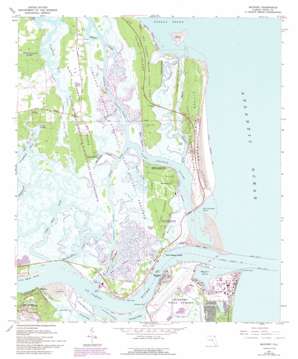
Mayport Topo Map Florida
To zoom in, hover over the map of Mayport
USGS Topo Quad 30081d4 - 1:24,000 scale
| Topo Map Name: | Mayport |
| USGS Topo Quad ID: | 30081d4 |
| Print Size: | ca. 21 1/4" wide x 27" high |
| Southeast Coordinates: | 30.375° N latitude / 81.375° W longitude |
| Map Center Coordinates: | 30.4375° N latitude / 81.4375° W longitude |
| U.S. State: | FL |
| Filename: | O30081D4.jpg |
| Download Map JPG Image: | Mayport topo map 1:24,000 scale |
| Map Type: | Topographic |
| Topo Series: | 7.5´ |
| Map Scale: | 1:24,000 |
| Source of Map Images: | United States Geological Survey (USGS) |
| Alternate Map Versions: |
Mayport FL 1950 Download PDF Buy paper map Mayport FL 1964, updated 1965 Download PDF Buy paper map Mayport FL 1964, updated 1972 Download PDF Buy paper map Mayport FL 1964, updated 1977 Download PDF Buy paper map Mayport FL 1964, updated 1982 Download PDF Buy paper map Mayport FL 1964, updated 1992 Download PDF Buy paper map Mayport FL 1964, updated 1992 Download PDF Buy paper map Mayport FL 1994, updated 2002 Download PDF Buy paper map Mayport FL 2012 Download PDF Buy paper map Mayport FL 2015 Download PDF Buy paper map |
1:24,000 Topo Quads surrounding Mayport
Gross |
Saint Marys |
Fernandina Beach |
||
Italia |
Hedges |
Amelia City |
||
Trout River |
Eastport |
Mayport |
||
Jacksonville |
Arlington |
Jacksonville Beach |
||
Orange Park |
Bayard |
Palm Valley |
Mickler Landing |
> Back to 30081a1 at 1:100,000 scale
> Back to 30080a1 at 1:250,000 scale
> Back to U.S. Topo Maps home
Mayport topo map: Gazetteer
Mayport: Airports
Mosquito Control Heliport elevation 1m 3′Mayport: Basins
Mayport Basin elevation 0m 0′Mayport: Bays
Broward Creek elevation 1m 3′Mayport: Beaches
Seminole Beach elevation 2m 6′Mayport: Capes
Mile Point elevation 0m 0′Saint Johns Point elevation 0m 0′
Sherman Point elevation 0m 0′
Mayport: Channels
Mayport Cut Range elevation 0m 0′Mile Point Lower Range and Turn elevation 0m 0′
Sherman Cut Range elevation 0m 0′
Short Cut Reach elevation 0m 0′
Training Wall Reach elevation 0m 0′
White Shells Cut Range elevation 0m 0′
Mayport: Cliffs
Half Moon Bluff elevation 3m 9′Saint Johns Bluff elevation 7m 22′
Mayport: Dams
North Jetty elevation 0m 0′South Jetty elevation 0m 0′
Mayport: Guts
Cedar Point Creek elevation 0m 0′Colorinda Creek elevation 1m 3′
Deep Creek elevation 1m 3′
Fort George Inlet elevation 0m 0′
Fort George River elevation 0m 0′
Gunnison Cut elevation 0m 0′
Hannah Mills Creek elevation 0m 0′
Haulover Creek elevation 3m 9′
Horseshoe Creek elevation 1m 3′
Mud River elevation 0m 0′
Myrtle Creek elevation 1m 3′
Saint Johns Creek elevation 2m 6′
Shad Creek elevation 3m 9′
Simpson Creek elevation 3m 9′
Sisters Creek elevation 0m 0′
Mayport: Islands
Batten Island elevation 3m 9′Bird Island elevation 1m 3′
Coon Key elevation 3m 9′
Fanning Island elevation 3m 9′
Fort George Island elevation 5m 16′
Great Marsh Island elevation 1m 3′
Little Marsh Island elevation 3m 9′
Little Talbot Island elevation 3m 9′
Long Island elevation 6m 19′
Pine Island elevation 3m 9′
Shell Island elevation 0m 0′
Sisters Island elevation 1m 3′
Talbot Island elevation 4m 13′
Mayport: Lakes
Round Pond elevation 3m 9′Mayport: Levees
Wards Bank elevation 0m 0′Mayport: Parks
Big Talbot Island State Park elevation 4m 13′Fort Caroline National Memorial elevation 5m 16′
Fort George Island Cultural State Park elevation 3m 9′
Huguenot Memorial Park elevation 1m 3′
Kingsley Plantation State Historical Site elevation 3m 9′
Little Talbot Island State Park elevation 1m 3′
Muncillia House elevation 3m 9′
Ribault Monument elevation 22m 72′
Timucuan Ecological and Historical Preserve elevation 1m 3′
Mayport: Populated Places
Cedar Point elevation 3m 9′East Mayport elevation 2m 6′
East Mayport (historical) elevation 3m 9′
Fort George Island elevation 3m 9′
Fulton elevation 5m 16′
Mayport elevation 3m 9′
Mayport: Streams
Garden Creek elevation 0m 0′Saint Johns River elevation 0m 0′
Mayport: Summits
Mount Cornelia elevation 15m 49′Mayport: Swamps
Cabbage Hammock Swamp elevation 3m 9′Greys Swamp elevation 3m 9′
Mayport digital topo map on disk
Buy this Mayport topo map showing relief, roads, GPS coordinates and other geographical features, as a high-resolution digital map file on DVD:


