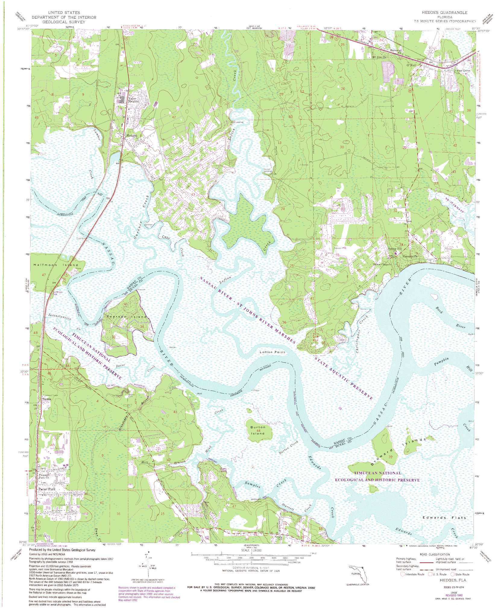
Hedges Topo Map Florida
To zoom in, hover over the map of Hedges
USGS Topo Quad 30081e5 - 1:24,000 scale
| Topo Map Name: | Hedges |
| USGS Topo Quad ID: | 30081e5 |
| Print Size: | ca. 21 1/4" wide x 27" high |
| Southeast Coordinates: | 30.5° N latitude / 81.5° W longitude |
| Map Center Coordinates: | 30.5625° N latitude / 81.5625° W longitude |
| U.S. State: | FL |
| Filename: | O30081E5.jpg |
| Download Map JPG Image: | Hedges topo map 1:24,000 scale |
| Map Type: | Topographic |
| Topo Series: | 7.5´ |
| Map Scale: | 1:24,000 |
| Source of Map Images: | United States Geological Survey (USGS) |
| Alternate Map Versions: |
Hedges FL 1958, updated 1959 Download PDF Buy paper map Hedges FL 1958, updated 1972 Download PDF Buy paper map Hedges FL 1958, updated 1975 Download PDF Buy paper map Hedges FL 1958, updated 1982 Download PDF Buy paper map Hedges FL 1958, updated 1988 Download PDF Buy paper map Hedges FL 1958, updated 1992 Download PDF Buy paper map Hedges FL 2012 Download PDF Buy paper map Hedges FL 2015 Download PDF Buy paper map |
1:24,000 Topo Quads surrounding Hedges
Kings Ferry |
Kingsland |
Harrietts Bluff |
Cumberland Island South |
|
Hilliard Ne |
Gross |
Saint Marys |
Fernandina Beach |
|
Callahan |
Italia |
Hedges |
Amelia City |
|
Dinsmore |
Trout River |
Eastport |
Mayport |
|
Marietta |
Jacksonville |
Arlington |
Jacksonville Beach |
> Back to 30081e1 at 1:100,000 scale
> Back to 30080a1 at 1:250,000 scale
> Back to U.S. Topo Maps home
Hedges topo map: Gazetteer
Hedges: Airports
Flying-A-Ranch Airport elevation 5m 16′Nassau Baptist Temple Field elevation 7m 22′
Hedges: Capes
Lofton Point elevation 0m 0′Hedges: Channels
Edwards Creek elevation 0m 0′Samples Creek elevation 0m 0′
Starrett Creek elevation 0m 0′
Hedges: Flats
Edwards Flats elevation 0m 0′Hedges: Islands
Broward Islands elevation 1m 3′Burton Island elevation 1m 3′
Halfmoon Island elevation 3m 9′
Pearson Island elevation 0m 0′
Pearson Island elevation 0m 0′
Hedges: Parks
Halfmoon Park elevation 1m 3′Hedges: Populated Places
Hedges elevation 7m 22′Nassauville elevation 4m 13′
O'Neil elevation 3m 9′
Pecan Park elevation 11m 36′
Shady Rest elevation 3m 9′
Tisonia elevation 9m 29′
Yulee Heights elevation 10m 32′
Hedges: Streams
Burton Creek elevation 0m 0′Christopher Creek elevation 0m 0′
Cuno Creek elevation 0m 0′
Deese Creek elevation 0m 0′
Gardner Creek elevation 0m 0′
Grandaddy Branch elevation 1m 3′
Inconstantion Creek elevation 0m 0′
Lofton Creek elevation 0m 0′
Lumber Creek elevation 0m 0′
Mill Branch elevation 0m 0′
Mink Creek elevation 0m 0′
Pumpkin Hill Creek elevation 0m 0′
Hedges digital topo map on disk
Buy this Hedges topo map showing relief, roads, GPS coordinates and other geographical features, as a high-resolution digital map file on DVD: