Lake City West Topo Map Florida
To zoom in, hover over the map of Lake City West
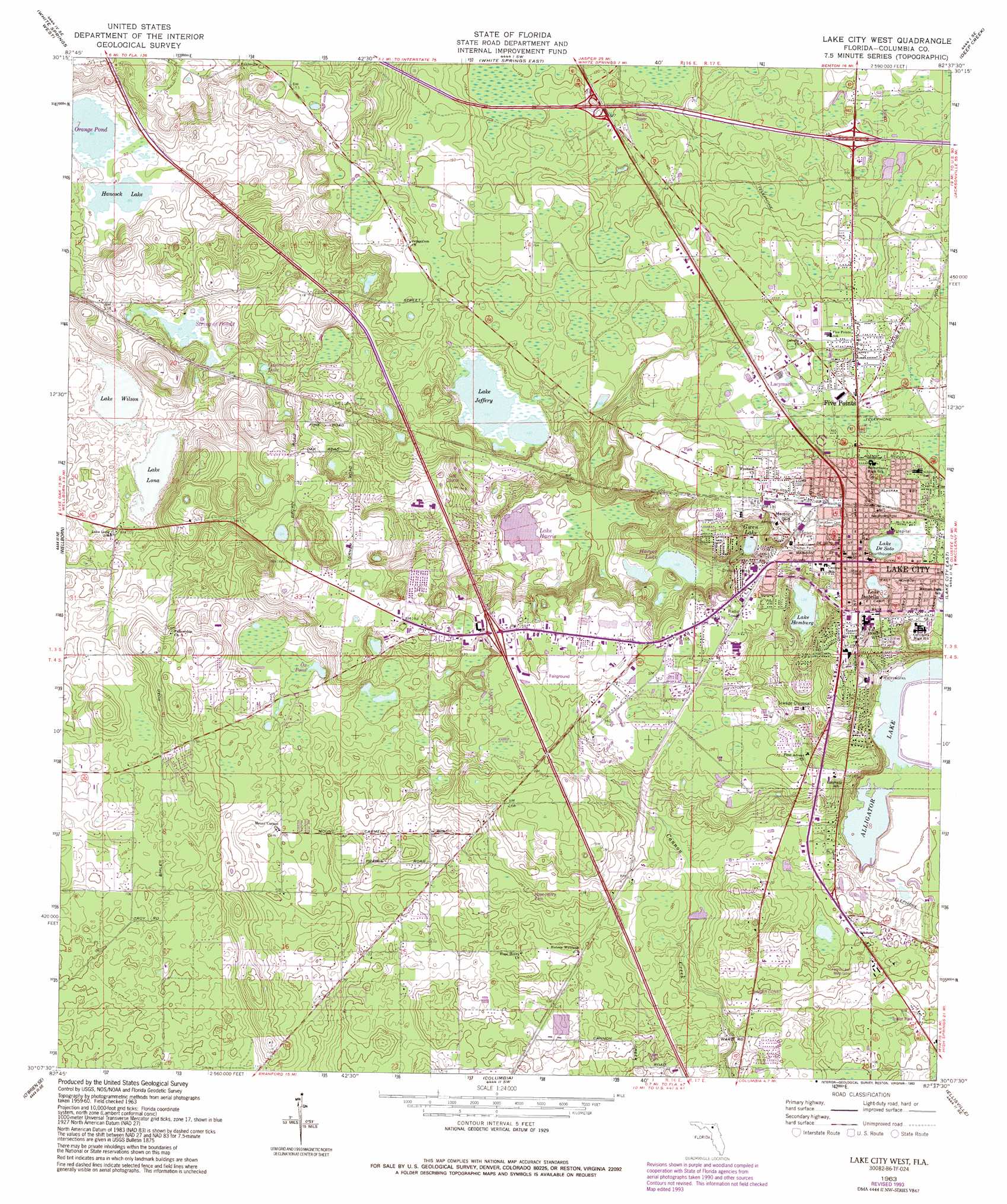
USGS Topo Quad 30082b6 - 1:24,000 scale
| Topo Map Name: | Lake City West |
| USGS Topo Quad ID: | 30082b6 |
| Print Size: | ca. 21 1/4" wide x 27" high |
| Southeast Coordinates: | 30.125° N latitude / 82.625° W longitude |
| Map Center Coordinates: | 30.1875° N latitude / 82.6875° W longitude |
| U.S. State: | FL |
| Filename: | O30082B6.jpg |
| Download Map JPG Image: | Lake City West topo map 1:24,000 scale |
| Map Type: | Topographic |
| Topo Series: | 7.5´ |
| Map Scale: | 1:24,000 |
| Source of Map Images: | United States Geological Survey (USGS) |
| Alternate Map Versions: |
Lake City West FL 1963, updated 1965 Download PDF Buy paper map Lake City West FL 1963, updated 1993 Download PDF Buy paper map Lake City West FL 2012 Download PDF Buy paper map Lake City West FL 2015 Download PDF Buy paper map |
| FStopo: | US Forest Service topo Lake City West is available: Download FStopo PDF Download FStopo TIF |
1:24,000 Topo Quads surrounding Lake City West
Hillcoat |
Genoa |
Benton |
Fairview |
Sanderson Nw |
Live Oak East |
White Springs West |
White Springs East |
Deep Creek |
Big Gum Swamp |
Mcalpin |
Wellborn |
Lake City West |
Lake City East |
Olustee |
O'Brien |
O'Brien Se |
Columbia |
Ellisville |
Lulu |
Branford |
Hildreth |
Fort White |
Mikesville |
Worthington Springs |
> Back to 30082a1 at 1:100,000 scale
> Back to 30082a1 at 1:250,000 scale
> Back to U.S. Topo Maps home
Lake City West topo map: Gazetteer
Lake City West: Airports
Cannon Creek Airport elevation 36m 118′Delta Airport elevation 31m 101′
Lake Shore Hospital Heliport elevation 56m 183′
Lake City West: Crossings
Columbia County School Board Administrative Complex elevation 59m 193′Lake City West: Lakes
Alligator Lake elevation 30m 98′Casterline Lake elevation 28m 91′
Gwen Lake elevation 38m 124′
Hancock Lake elevation 26m 85′
Harper Lake elevation 31m 101′
Lake Hamburg elevation 39m 127′
Lake Harris elevation 29m 95′
Lake Jeffery elevation 40m 131′
Lake Lona elevation 23m 75′
Lake Wilson elevation 25m 82′
Ox Pond elevation 31m 101′
String of Ponds elevation 28m 91′
Lake City West: Parks
Annie Mattox Park elevation 55m 180′Columbia High School Stadium elevation 34m 111′
Five Points Park elevation 53m 173′
Memorial Stadium elevation 58m 190′
Youngs Park elevation 56m 183′
Lake City West: Populated Places
Bedenbaugh Mobile Home Park elevation 30m 98′Deer Run Mobile Home Park elevation 49m 160′
Five Points elevation 50m 164′
Halpata (historical) elevation 57m 187′
Hill Circle Mobile Home Park elevation 49m 160′
Hopeful Circle Village Mobile Home Park elevation 57m 187′
Lacymark elevation 53m 173′
Lake City elevation 59m 193′
Lake Harper Mobile Home Park elevation 33m 108′
Miltons Campground Number 1 elevation 53m 173′
Rolling Meadows elevation 32m 104′
West Pines Village Mobile Home Park elevation 50m 164′
Westgate Mobile Home Park elevation 47m 154′
Lake City West: Post Offices
Lake City Main Post Office elevation 61m 200′Lake City West: Reservoirs
Lake De Soto elevation 55m 180′Lake Isabella elevation 54m 177′
Orange Pond elevation 27m 88′
Lake City West digital topo map on disk
Buy this Lake City West topo map showing relief, roads, GPS coordinates and other geographical features, as a high-resolution digital map file on DVD: