Dinner Pond Topo Map Georgia
To zoom in, hover over the map of Dinner Pond
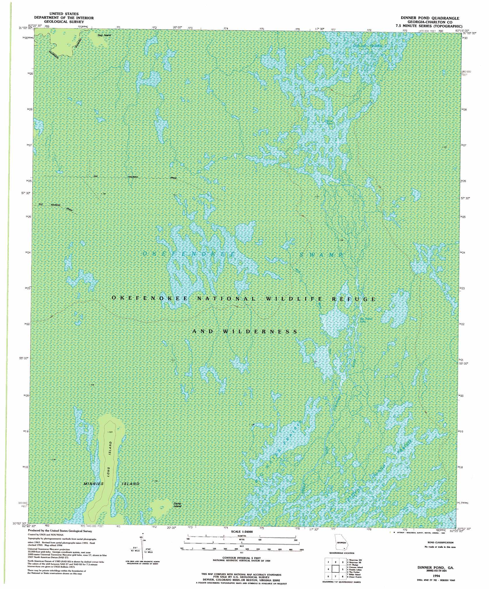
USGS Topo Quad 30082h3 - 1:24,000 scale
| Topo Map Name: | Dinner Pond |
| USGS Topo Quad ID: | 30082h3 |
| Print Size: | ca. 21 1/4" wide x 27" high |
| Southeast Coordinates: | 30.875° N latitude / 82.25° W longitude |
| Map Center Coordinates: | 30.9375° N latitude / 82.3125° W longitude |
| U.S. State: | GA |
| Filename: | o30082h3.jpg |
| Download Map JPG Image: | Dinner Pond topo map 1:24,000 scale |
| Map Type: | Topographic |
| Topo Series: | 7.5´ |
| Map Scale: | 1:24,000 |
| Source of Map Images: | United States Geological Survey (USGS) |
| Alternate Map Versions: |
Dinner Pond GA 1965, updated 1967 Download PDF Buy paper map Dinner Pond GA 1965, updated 1991 Download PDF Buy paper map Dinner Pond GA 1994, updated 1994 Download PDF Buy paper map Dinner Pond GA 2011 Download PDF Buy paper map Dinner Pond GA 2014 Download PDF Buy paper map |
1:24,000 Topo Quads surrounding Dinner Pond
Pine Valley |
Waycross West |
Waycross East |
Hoboken West |
Hoboken East |
Manor |
Waycross Sw |
Waycross Se |
Fort Mudge |
Winokur |
Spooner |
Cravens Island |
Dinner Pond |
Double Lakes |
Newell |
Colon |
The Pocket |
Billys Island |
Chase Prairie |
Folkston |
Fargo |
Strange Island |
Blackjack Island |
Chesser Island |
Toledo |
> Back to 30082e1 at 1:100,000 scale
> Back to 30082a1 at 1:250,000 scale
> Back to U.S. Topo Maps home
Dinner Pond topo map: Gazetteer
Dinner Pond: Islands
Camp Island elevation 35m 114′Dog Island elevation 38m 124′
Long Island elevation 37m 121′
Dinner Pond: Lakes
Big Water Lake elevation 35m 114′Dinner Pond elevation 35m 114′
Dinner Pond: Streams
Bird Wing Run elevation 35m 114′Dinner Pond: Swamps
Big Water Prairie elevation 35m 114′Floyds Island Prairie elevation 35m 114′
Dinner Pond: Trails
Okefenokee Wilderness Canoe Trail elevation 35m 114′Dinner Pond digital topo map on disk
Buy this Dinner Pond topo map showing relief, roads, GPS coordinates and other geographical features, as a high-resolution digital map file on DVD: