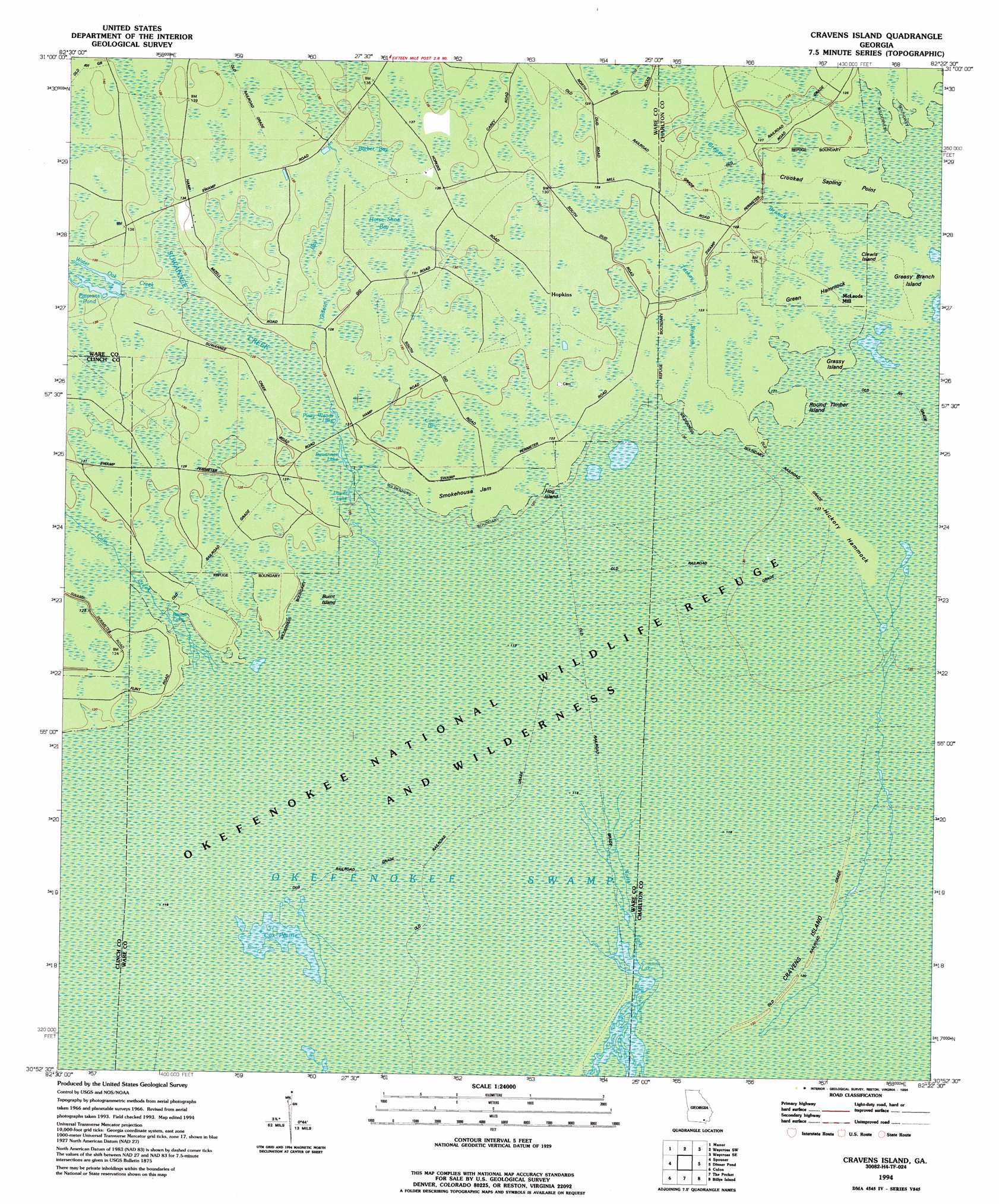
Cravens Island Topo Map Georgia
To zoom in, hover over the map of Cravens Island
USGS Topo Quad 30082h4 - 1:24,000 scale
| Topo Map Name: | Cravens Island |
| USGS Topo Quad ID: | 30082h4 |
| Print Size: | ca. 21 1/4" wide x 27" high |
| Southeast Coordinates: | 30.875° N latitude / 82.375° W longitude |
| Map Center Coordinates: | 30.9375° N latitude / 82.4375° W longitude |
| U.S. State: | GA |
| Filename: | o30082h4.jpg |
| Download Map JPG Image: | Cravens Island topo map 1:24,000 scale |
| Map Type: | Topographic |
| Topo Series: | 7.5´ |
| Map Scale: | 1:24,000 |
| Source of Map Images: | United States Geological Survey (USGS) |
| Alternate Map Versions: |
Cravens Island GA 1966, updated 1968 Download PDF Buy paper map Cravens Island GA 1994, updated 1994 Download PDF Buy paper map Cravens Island GA 2011 Download PDF Buy paper map Cravens Island GA 2014 Download PDF Buy paper map |
1:24,000 Topo Quads surrounding Cravens Island
Cogdell |
Pine Valley |
Waycross West |
Waycross East |
Hoboken West |
Homerville East |
Manor |
Waycross Sw |
Waycross Se |
Fort Mudge |
Midway |
Spooner |
Cravens Island |
Dinner Pond |
Double Lakes |
Headlight |
Colon |
The Pocket |
Billys Island |
Chase Prairie |
Needmore |
Fargo |
Strange Island |
Blackjack Island |
Chesser Island |
> Back to 30082e1 at 1:100,000 scale
> Back to 30082a1 at 1:250,000 scale
> Back to U.S. Topo Maps home
Cravens Island topo map: Gazetteer
Cravens Island: Capes
Crooked Sapling Point elevation 38m 124′Cravens Island: Flats
Smokehouse Jam elevation 37m 121′Cravens Island: Islands
Burnt Island elevation 36m 118′Clewis Island elevation 37m 121′
Cravens Island elevation 36m 118′
Grassy Island elevation 37m 121′
Greasy Branch Island elevation 37m 121′
Green Hammock elevation 37m 121′
Hickory Hammock elevation 37m 121′
Hog Island elevation 36m 118′
Round Timber Island elevation 37m 121′
Cravens Island: Lakes
Boone Lake elevation 36m 118′Lower Lake elevation 37m 121′
Piney Woods Lake elevation 37m 121′
Pittmans Pond elevation 40m 131′
Suwannee Lake elevation 37m 121′
Cravens Island: Populated Places
Hopkins elevation 38m 124′McLeods Mill elevation 37m 121′
Cravens Island: Streams
Cane Creek elevation 36m 118′Greasy Branch elevation 37m 121′
Suwannee Creek elevation 36m 118′
Turkey Branch elevation 36m 118′
Water Oak Creek elevation 37m 121′
Cravens Island: Swamps
Cox Prairie elevation 35m 114′Cravens Island digital topo map on disk
Buy this Cravens Island topo map showing relief, roads, GPS coordinates and other geographical features, as a high-resolution digital map file on DVD: