Madison Se Topo Map Florida
To zoom in, hover over the map of Madison Se
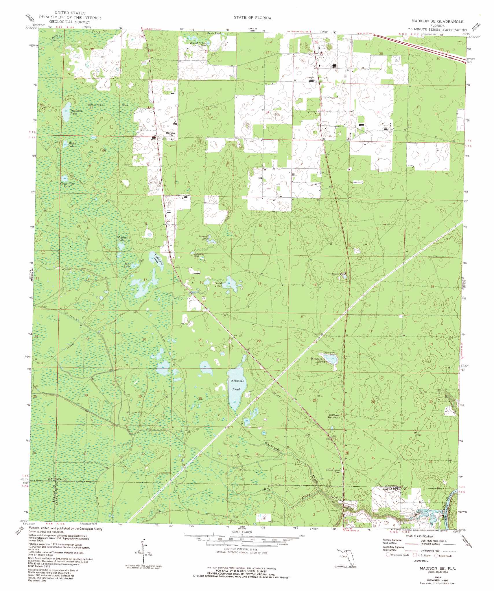
USGS Topo Quad 30083c3 - 1:24,000 scale
| Topo Map Name: | Madison Se |
| USGS Topo Quad ID: | 30083c3 |
| Print Size: | ca. 21 1/4" wide x 27" high |
| Southeast Coordinates: | 30.25° N latitude / 83.25° W longitude |
| Map Center Coordinates: | 30.3125° N latitude / 83.3125° W longitude |
| U.S. State: | FL |
| Filename: | O30083C3.jpg |
| Download Map JPG Image: | Madison Se topo map 1:24,000 scale |
| Map Type: | Topographic |
| Topo Series: | 7.5´ |
| Map Scale: | 1:24,000 |
| Source of Map Images: | United States Geological Survey (USGS) |
| Alternate Map Versions: |
Madison SE FL 1958, updated 1959 Download PDF Buy paper map Madison SE FL 1958, updated 1976 Download PDF Buy paper map Madison SE FL 1958, updated 1993 Download PDF Buy paper map Madison SE FL 2012 Download PDF Buy paper map Madison SE FL 2015 Download PDF Buy paper map |
1:24,000 Topo Quads surrounding Madison Se
Hamburg |
Cherry Lake |
Pinetta |
Octahatchee |
Jennings |
Greenville Ne |
Madison |
Lee |
Ellaville |
Fort Union |
Greenville Se |
Madison Sw |
Madison Se |
Falmouth |
Live Oak West |
Boyd |
Day Nw |
Day |
Dowling Park |
Mayo Ne |
Perry |
Fenholloway |
Day Se |
Mayo |
Mayo Se |
> Back to 30083a1 at 1:100,000 scale
> Back to 30082a1 at 1:250,000 scale
> Back to U.S. Topo Maps home
Madison Se topo map: Gazetteer
Madison Se: Basins
Johnson Sink elevation 33m 108′Mitchel Sink elevation 27m 88′
Madison Se: Lakes
Cross Way Lake elevation 47m 154′Hicks Lake elevation 41m 134′
McKay Lake elevation 28m 91′
Pacolson Lake elevation 29m 95′
Pine Lake elevation 28m 91′
Sand Pond elevation 27m 88′
Tenmile Pond elevation 27m 88′
Water Pond elevation 28m 91′
Williams Waterhole elevation 33m 108′
Winquepin Pond elevation 23m 75′
Madison Se: Reservoirs
Davis Pond elevation 30m 98′Round Brown Pond elevation 31m 101′
Twelvemile Pond elevation 28m 91′
Madison Se: Streams
Bethel Creek elevation 18m 59′Blacksnake Creek elevation 24m 78′
Madison Se: Swamps
Patterson Sink elevation 37m 121′Madison Se digital topo map on disk
Buy this Madison Se topo map showing relief, roads, GPS coordinates and other geographical features, as a high-resolution digital map file on DVD: