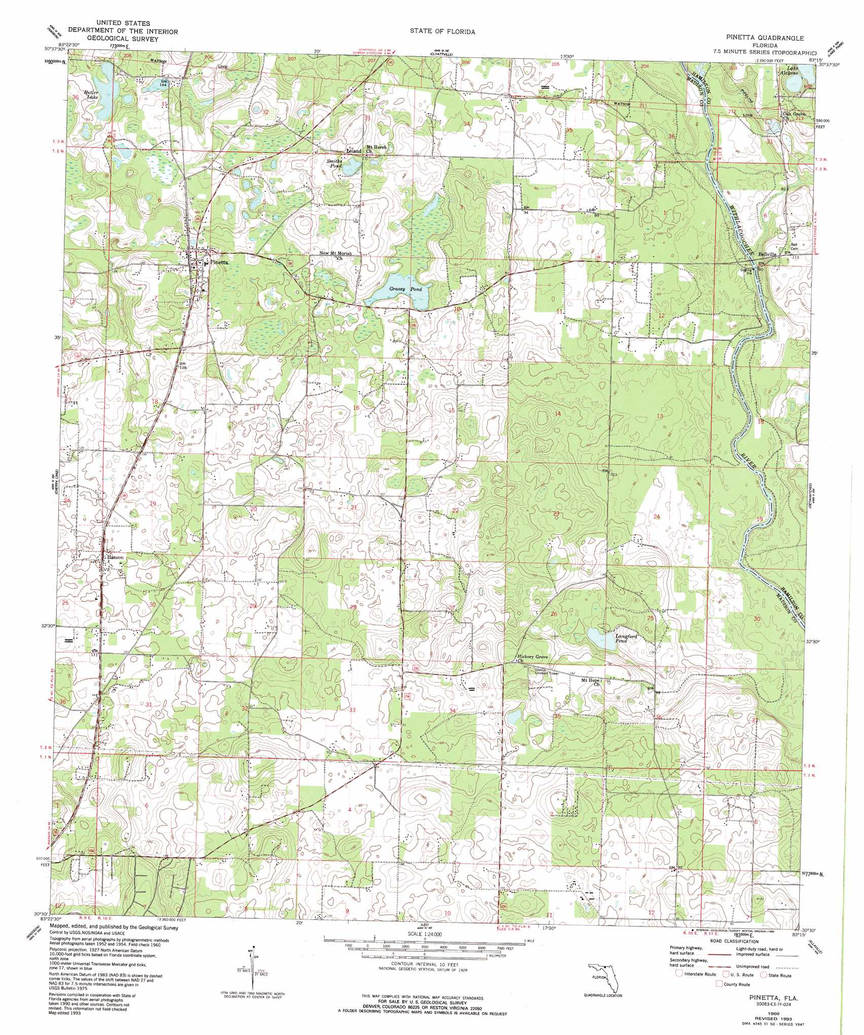
Pinetta Topo Map Florida
To zoom in, hover over the map of Pinetta
USGS Topo Quad 30083e3 - 1:24,000 scale
| Topo Map Name: | Pinetta |
| USGS Topo Quad ID: | 30083e3 |
| Print Size: | ca. 21 1/4" wide x 27" high |
| Southeast Coordinates: | 30.5° N latitude / 83.25° W longitude |
| Map Center Coordinates: | 30.5625° N latitude / 83.3125° W longitude |
| U.S. State: | FL |
| Filename: | O30083E3.jpg |
| Download Map JPG Image: | Pinetta topo map 1:24,000 scale |
| Map Type: | Topographic |
| Topo Series: | 7.5´ |
| Map Scale: | 1:24,000 |
| Source of Map Images: | United States Geological Survey (USGS) |
| Alternate Map Versions: |
Pinetta FL 1960, updated 1961 Download PDF Buy paper map Pinetta FL 1960, updated 1980 Download PDF Buy paper map Pinetta FL 1960, updated 1984 Download PDF Buy paper map Pinetta FL 1960, updated 1993 Download PDF Buy paper map Pinetta FL 2012 Download PDF Buy paper map Pinetta FL 2015 Download PDF Buy paper map |
1:24,000 Topo Quads surrounding Pinetta
Quitman |
Ousley |
Valdosta |
Indianola |
Howell |
Baden |
Nankin |
Clyattville |
Lake Park |
Statenville |
Hamburg |
Cherry Lake |
Pinetta |
Octahatchee |
Jennings |
Greenville Ne |
Madison |
Lee |
Ellaville |
Fort Union |
Greenville Se |
Madison Sw |
Madison Se |
Falmouth |
Live Oak West |
> Back to 30083e1 at 1:100,000 scale
> Back to 30082a1 at 1:250,000 scale
> Back to U.S. Topo Maps home
Pinetta topo map: Gazetteer
Pinetta: Airports
A and H Farm Airport elevation 28m 91′Bass Limited Airport elevation 30m 98′
Bird Field elevation 49m 160′
Pinetta: Lakes
Butler Lake elevation 42m 137′Grassy Pond elevation 29m 95′
Lake Alcyone elevation 34m 111′
Langford Pond elevation 27m 88′
Smiths Pond elevation 38m 124′
Pinetta: Populated Places
Bellville elevation 33m 108′Etotulga (historical) elevation 30m 98′
Hanson elevation 30m 98′
Leland elevation 40m 131′
Pinetta elevation 46m 150′
Pinetta: Streams
Jumping Gully Creek elevation 17m 55′Pinetta digital topo map on disk
Buy this Pinetta topo map showing relief, roads, GPS coordinates and other geographical features, as a high-resolution digital map file on DVD: