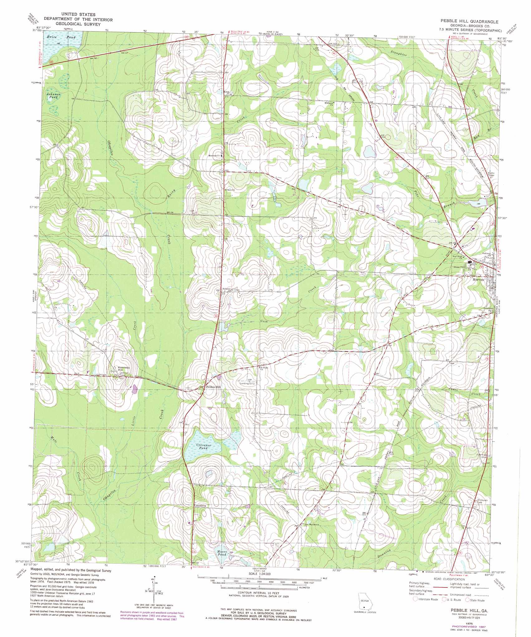
Pebble Hill Topo Map Georgia
To zoom in, hover over the map of Pebble Hill
USGS Topo Quad 30083h5 - 1:24,000 scale
| Topo Map Name: | Pebble Hill |
| USGS Topo Quad ID: | 30083h5 |
| Print Size: | ca. 21 1/4" wide x 27" high |
| Southeast Coordinates: | 30.875° N latitude / 83.5° W longitude |
| Map Center Coordinates: | 30.9375° N latitude / 83.5625° W longitude |
| U.S. State: | GA |
| Filename: | o30083h5.jpg |
| Download Map JPG Image: | Pebble Hill topo map 1:24,000 scale |
| Map Type: | Topographic |
| Topo Series: | 7.5´ |
| Map Scale: | 1:24,000 |
| Source of Map Images: | United States Geological Survey (USGS) |
| Alternate Map Versions: |
Pebble Hill GA 1975, updated 1987 Download PDF Buy paper map Pebble Hill GA 1978, updated 1978 Download PDF Buy paper map Pebble Hill GA 2011 Download PDF Buy paper map Pebble Hill GA 2014 Download PDF Buy paper map |
1:24,000 Topo Quads surrounding Pebble Hill
Moultrie |
Pineboro |
Ellenton |
Adel |
Nashville West |
Coolidge |
Berlin West |
Berlin East |
Cecil |
New Lois |
Patten |
Pavo |
Pebble Hill |
Hahira West |
Hahira East |
Boston |
Dixie |
Quitman |
Ousley |
Valdosta |
Monticello Ne |
Grooverville |
Baden |
Nankin |
Clyattville |
> Back to 30083e1 at 1:100,000 scale
> Back to 30082a1 at 1:250,000 scale
> Back to U.S. Topo Maps home
Pebble Hill topo map: Gazetteer
Pebble Hill: Dams
McMillian Lake Dam elevation 54m 177′Moore Lake Dam elevation 56m 183′
Pebble Hill: Lakes
Johnson Pond elevation 47m 154′Pebble Hill: Populated Places
Kennedy (historical) elevation 70m 229′Pebble Hill elevation 62m 203′
Tallokas (historical) elevation 50m 164′
Pebble Hill: Post Offices
Morven Post Office elevation 67m 219′Pebble Hill: Reservoirs
Crevasse Pond elevation 44m 144′McMillian Lake elevation 54m 177′
Moore Lake elevation 56m 183′
Moore Pond elevation 55m 180′
Pebble Hill: Streams
Bay Branch elevation 53m 173′Gum Creek elevation 42m 137′
Little Creek elevation 39m 127′
Mule Creek elevation 39m 127′
Rainy Creek elevation 45m 147′
Pebble Hill: Summits
Kennedy Hill elevation 70m 229′Pebble Hill digital topo map on disk
Buy this Pebble Hill topo map showing relief, roads, GPS coordinates and other geographical features, as a high-resolution digital map file on DVD: