Sanborn Topo Map Florida
To zoom in, hover over the map of Sanborn
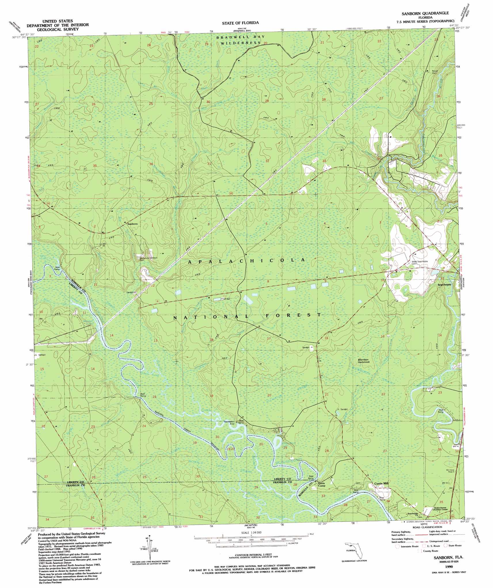
USGS Topo Quad 30084a5 - 1:24,000 scale
| Topo Map Name: | Sanborn |
| USGS Topo Quad ID: | 30084a5 |
| Print Size: | ca. 21 1/4" wide x 27" high |
| Southeast Coordinates: | 30° N latitude / 84.5° W longitude |
| Map Center Coordinates: | 30.0625° N latitude / 84.5625° W longitude |
| U.S. State: | FL |
| Filename: | O30084A5.jpg |
| Download Map JPG Image: | Sanborn topo map 1:24,000 scale |
| Map Type: | Topographic |
| Topo Series: | 7.5´ |
| Map Scale: | 1:24,000 |
| Source of Map Images: | United States Geological Survey (USGS) |
| Alternate Map Versions: |
Sanborn FL 1945, updated 1960 Download PDF Buy paper map Sanborn FL 1990, updated 1990 Download PDF Buy paper map Sanborn FL 2012 Download PDF Buy paper map Sanborn FL 2015 Download PDF Buy paper map |
| FStopo: | US Forest Service topo Sanborn is available: Download FStopo PDF Download FStopo TIF |
1:24,000 Topo Quads surrounding Sanborn
Telogia |
Ward |
Lake Talquin Se |
Hilliardville |
Lake Munson |
Queens Bay |
Smith Creek |
Bradwell Bay |
Crawfordville West |
Crawfordville East |
Owens Bridge |
Thousand Yard Bay |
Sanborn |
Sopchoppy |
Spring Creek |
Tates Hell Swamp |
Pickett Bay |
Mcintyre |
Saint Teresa Beach |
Lighthouse Point |
Green Point |
Carrabelle |
Dog Island |
> Back to 30084a1 at 1:100,000 scale
> Back to 30084a1 at 1:250,000 scale
> Back to U.S. Topo Maps home
Sanborn topo map: Gazetteer
Sanborn: Bends
Sanborn Cutoff elevation 1m 3′Sufrett Cutoff elevation 1m 3′
Sanborn: Guts
Baker Branch elevation 4m 13′Titi Branch elevation 12m 39′
Sanborn: Islands
Morrison Hammock elevation 4m 13′Sanborn: Lakes
Bone Bluff Lake elevation 1m 3′Marshall Lakes elevation 1m 3′
Sanborn Lake elevation 1m 3′
Silver Lake elevation 1m 3′
Wood Lake elevation 1m 3′
Sanborn: Parks
Morrison Hammock Scenic Area elevation 6m 19′Sanborn: Populated Places
Curtis Mill elevation 4m 13′Sanborn elevation 11m 36′
Sanborn: Streams
Alligator Creek elevation 1m 3′Big Spring Creek elevation 2m 6′
Bostick Branch elevation 5m 16′
Bumpy Creek elevation 1m 3′
Camp Branch elevation 11m 36′
Cow Creek elevation 1m 3′
Deep Branch elevation 1m 3′
Duval Branch elevation 1m 3′
East Fork Syfrett Creek elevation 10m 32′
Haw Creek elevation 1m 3′
Joel Branch elevation 10m 32′
Mill Creek elevation 11m 36′
Mill Creek elevation 1m 3′
Schoolhouse Branch elevation 6m 19′
Syfrett Creek elevation 1m 3′
Titi Branch elevation 9m 29′
West Fork Syfrett Creek elevation 10m 32′
Womack Creek elevation 0m 0′
Sanborn: Swamps
Alligator Swamp elevation 5m 16′Womack Creek Swamp elevation 1m 3′
Sanborn digital topo map on disk
Buy this Sanborn topo map showing relief, roads, GPS coordinates and other geographical features, as a high-resolution digital map file on DVD:
Gulf Coast (LA, MS, AL, FL) & Southwestern Georgia
Buy digital topo maps: Gulf Coast (LA, MS, AL, FL) & Southwestern Georgia
 & Southwestern Georgia map DVD")