Saint Marks Topo Map Florida
To zoom in, hover over the map of Saint Marks
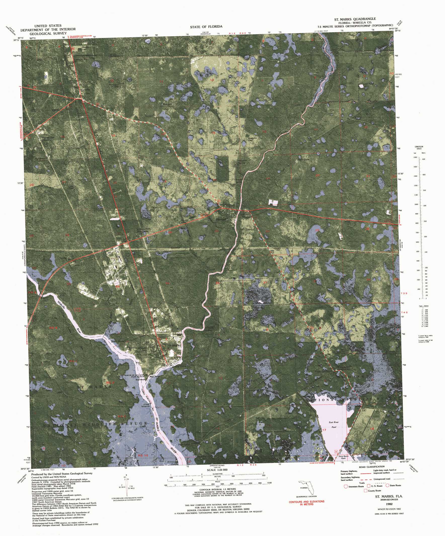
USGS Topo Quad 30084b2 - 1:24,000 scale
| Topo Map Name: | Saint Marks |
| USGS Topo Quad ID: | 30084b2 |
| Print Size: | ca. 21 1/4" wide x 27" high |
| Southeast Coordinates: | 30.125° N latitude / 84.125° W longitude |
| Map Center Coordinates: | 30.1875° N latitude / 84.1875° W longitude |
| U.S. State: | FL |
| Filename: | P30084B2.jpg |
| Download Map JPG Image: | Saint Marks topo map 1:24,000 scale |
| Map Type: | Orthophoto |
| Topo Series: | 7.5´ |
| Map Scale: | 1:24,000 |
| Source of Map Images: | United States Geological Survey (USGS) |
| Alternate Map Versions: |
St. Marks FL 1954, updated 1956 Download PDF Buy paper map St Marks FL 1954, updated 1972 Download PDF Buy paper map St Marks FL 1982, updated 1983 Download PDF Buy paper map St. Marks FL 1982, updated 1983 Download PDF Buy paper map St. Marks FL 1982, updated 1983 Download PDF Buy paper map Saint Marks FL 2012 Download PDF Buy paper map Saint Marks FL 2015 Download PDF Buy paper map |
1:24,000 Topo Quads surrounding Saint Marks
Midway |
Tallahassee |
Lafayette |
Lloyd |
Waukeenah |
Hilliardville |
Lake Munson |
Woodville |
Cody |
Wacissa |
Crawfordville West |
Crawfordville East |
Saint Marks |
Saint Marks Ne |
Nutall Rise |
Sopchoppy |
Spring Creek |
Sprague Island |
Cobb Rocks |
Snipe Island |
Saint Teresa Beach |
Lighthouse Point |
> Back to 30084a1 at 1:100,000 scale
> Back to 30084a1 at 1:250,000 scale
> Back to U.S. Topo Maps home
Saint Marks topo map: Gazetteer
Saint Marks: Basins
Blue Sink elevation 4m 13′Patterson Sink elevation 6m 19′
Saint Marks: Bends
Allround Point elevation 1m 3′Saint Marks: Bridges
Lower Bridge elevation 1m 3′Newport Bridge elevation 3m 9′
Saint Marks: Islands
Collins Hammock elevation 2m 6′Joes Island elevation 1m 3′
Port Leon Hammock elevation 2m 6′
Saint Marks: Lakes
Oak Pond elevation 4m 13′Saint Marks: Parks
San Marcos De Apalache Historic State Park elevation 1m 3′Saint Marks: Populated Places
Newport elevation 3m 9′Plum Orchard elevation 3m 9′
Port Leon elevation 1m 3′
Saint Marks elevation 3m 9′
San Marcos (historical) elevation 3m 9′
Shell Island elevation 1m 3′
Wakulla elevation 5m 16′
Saint Marks: Reservoirs
East River Pool elevation 0m 0′Port Leon Lake elevation 1m 3′
Saint Marks: Springs
Newport Spring elevation 1m 3′Saint Marks: Streams
Big Boggy Branch elevation 1m 3′First Branch elevation 1m 3′
Moriah Creek elevation 1m 3′
Port Leon Creek elevation 0m 0′
Rattlesnake Branch elevation 1m 3′
Salt Pan Creek elevation 1m 3′
Wakulla River elevation 0m 0′
Saint Marks digital topo map on disk
Buy this Saint Marks topo map showing relief, roads, GPS coordinates and other geographical features, as a high-resolution digital map file on DVD:
Gulf Coast (LA, MS, AL, FL) & Southwestern Georgia
Buy digital topo maps: Gulf Coast (LA, MS, AL, FL) & Southwestern Georgia
 & Southwestern Georgia map DVD")