Lloyd Topo Map Florida
To zoom in, hover over the map of Lloyd
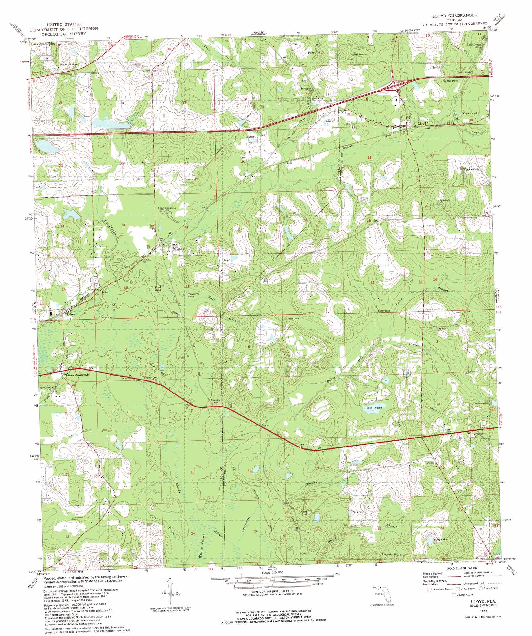
USGS Topo Quad 30084d1 - 1:24,000 scale
| Topo Map Name: | Lloyd |
| USGS Topo Quad ID: | 30084d1 |
| Print Size: | ca. 21 1/4" wide x 27" high |
| Southeast Coordinates: | 30.375° N latitude / 84° W longitude |
| Map Center Coordinates: | 30.4375° N latitude / 84.0625° W longitude |
| U.S. State: | FL |
| Filename: | O30084D1.jpg |
| Download Map JPG Image: | Lloyd topo map 1:24,000 scale |
| Map Type: | Topographic |
| Topo Series: | 7.5´ |
| Map Scale: | 1:24,000 |
| Source of Map Images: | United States Geological Survey (USGS) |
| Alternate Map Versions: |
Lloyd FL 1954, updated 1955 Download PDF Buy paper map Lloyd FL 1954, updated 1955 Download PDF Buy paper map Lloyd FL 1982, updated 1983 Download PDF Buy paper map Lloyd FL 2012 Download PDF Buy paper map Lloyd FL 2015 Download PDF Buy paper map |
1:24,000 Topo Quads surrounding Lloyd
Calvary |
Beachton |
Miccosukee Ne |
Metcalf |
Monticello Ne |
Lake Jackson |
Bradfordville |
Miccosukee |
Lake Miccosukee |
Monticello |
Tallahassee |
Lafayette |
Lloyd |
Waukeenah |
Lamont |
Lake Munson |
Woodville |
Cody |
Wacissa |
Lamont Se |
Crawfordville East |
Saint Marks |
Saint Marks Ne |
Nutall Rise |
Johnson Hammock |
> Back to 30084a1 at 1:100,000 scale
> Back to 30084a1 at 1:250,000 scale
> Back to U.S. Topo Maps home
Lloyd topo map: Gazetteer
Lloyd: Airports
Charlottes Field elevation 24m 78′Lloyd: Basins
Bird Sink elevation 20m 65′Copeland Sink elevation 13m 42′
Creek Sink elevation 24m 78′
Gray Sink elevation 33m 108′
Lake Drain Sink elevation 23m 75′
Patty Sink elevation 24m 78′
The Cascade elevation 26m 85′
Wood Sink elevation 15m 49′
Lloyd: Lakes
Brice Pond elevation 24m 78′Crow Pond elevation 28m 91′
Ox Lake elevation 38m 124′
Story Lake elevation 39m 127′
Upchurch Pond elevation 18m 59′
Willie Pond elevation 21m 68′
Lloyd: Populated Places
Capitola elevation 21m 68′Chaires elevation 18m 59′
Lloyd elevation 25m 82′
Lloyd: Reservoirs
Shadow Lake elevation 39m 127′Lloyd: Streams
Alfred Branch elevation 19m 62′Black Creek elevation 17m 55′
Burnt Mill Creek elevation 15m 49′
Hall Branch elevation 15m 49′
Lake Drain elevation 24m 78′
Lloyd Creek elevation 23m 75′
Polar Branch elevation 24m 78′
Still Creek elevation 21m 68′
Sweetwater Branch elevation 12m 39′
Lloyd digital topo map on disk
Buy this Lloyd topo map showing relief, roads, GPS coordinates and other geographical features, as a high-resolution digital map file on DVD:
Gulf Coast (LA, MS, AL, FL) & Southwestern Georgia
Buy digital topo maps: Gulf Coast (LA, MS, AL, FL) & Southwestern Georgia
 & Southwestern Georgia map DVD")