Lafayette Topo Map Florida
To zoom in, hover over the map of Lafayette
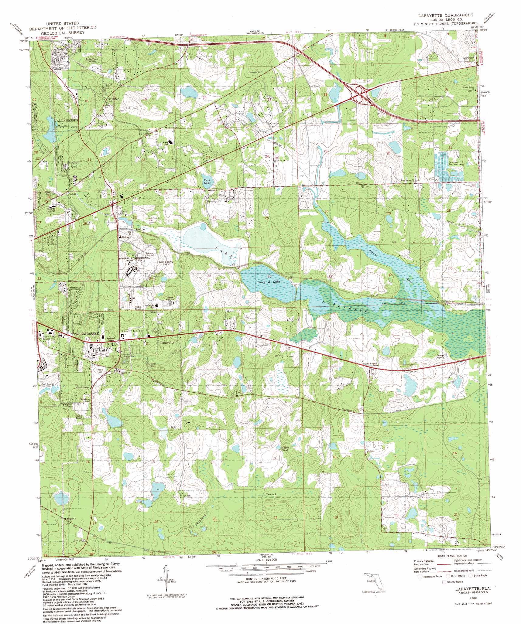
USGS Topo Quad 30084d2 - 1:24,000 scale
| Topo Map Name: | Lafayette |
| USGS Topo Quad ID: | 30084d2 |
| Print Size: | ca. 21 1/4" wide x 27" high |
| Southeast Coordinates: | 30.375° N latitude / 84.125° W longitude |
| Map Center Coordinates: | 30.4375° N latitude / 84.1875° W longitude |
| U.S. State: | FL |
| Filename: | O30084D2.jpg |
| Download Map JPG Image: | Lafayette topo map 1:24,000 scale |
| Map Type: | Topographic |
| Topo Series: | 7.5´ |
| Map Scale: | 1:24,000 |
| Source of Map Images: | United States Geological Survey (USGS) |
| Alternate Map Versions: |
Lafayette FL 1954, updated 1955 Download PDF Buy paper map Lafayette FL 1954, updated 1966 Download PDF Buy paper map Lafayette FL 1954, updated 1971 Download PDF Buy paper map Lafayette FL 1982, updated 1983 Download PDF Buy paper map Lafayette FL 1982, updated 1983 Download PDF Buy paper map Lafayette FL 1999, updated 2003 Download PDF Buy paper map Lafayette FL 2012 Download PDF Buy paper map Lafayette FL 2015 Download PDF Buy paper map |
1:24,000 Topo Quads surrounding Lafayette
Havana North |
Calvary |
Beachton |
Miccosukee Ne |
Metcalf |
Havana South |
Lake Jackson |
Bradfordville |
Miccosukee |
Lake Miccosukee |
Midway |
Tallahassee |
Lafayette |
Lloyd |
Waukeenah |
Hilliardville |
Lake Munson |
Woodville |
Cody |
Wacissa |
Crawfordville West |
Crawfordville East |
Saint Marks |
Saint Marks Ne |
Nutall Rise |
> Back to 30084a1 at 1:100,000 scale
> Back to 30084a1 at 1:250,000 scale
> Back to U.S. Topo Maps home
Lafayette topo map: Gazetteer
Lafayette: Lakes
Buck Lake elevation 20m 65′Hogan Pond elevation 23m 75′
J C Headley Pond elevation 26m 85′
J R Alford Pond elevation 14m 45′
Lafayette: Parks
A J Henry Park elevation 61m 200′Chaires Capitola Community Park elevation 34m 111′
Govenors Park elevation 24m 78′
J R Alford Greenway elevation 25m 82′
L Kirk Edwards State Wildlife and Environment Area elevation 13m 42′
Lake Lafayette Heritage Trail Park elevation 13m 42′
Tom Brown Park elevation 39m 127′
Lafayette: Populated Places
Gardner elevation 54m 177′Lafayette elevation 61m 200′
Perkins elevation 16m 52′
Saint Peter elevation 51m 167′
Lafayette: Reservoirs
Piney Z Lake elevation 13m 42′Lafayette: Streams
Shepherd Branch elevation 12m 39′Lafayette: Swamps
Alford Arm elevation 13m 42′Lake Lafayette elevation 13m 42′
Lafayette digital topo map on disk
Buy this Lafayette topo map showing relief, roads, GPS coordinates and other geographical features, as a high-resolution digital map file on DVD:
Gulf Coast (LA, MS, AL, FL) & Southwestern Georgia
Buy digital topo maps: Gulf Coast (LA, MS, AL, FL) & Southwestern Georgia
 & Southwestern Georgia map DVD")