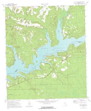
Lake Talquin Topo Map Florida
To zoom in, hover over the map of Lake Talquin
USGS Topo Quad 30084d5 - 1:24,000 scale
| Topo Map Name: | Lake Talquin |
| USGS Topo Quad ID: | 30084d5 |
| Print Size: | ca. 21 1/4" wide x 27" high |
| Southeast Coordinates: | 30.375° N latitude / 84.5° W longitude |
| Map Center Coordinates: | 30.4375° N latitude / 84.5625° W longitude |
| U.S. State: | FL |
| Filename: | O30084D5.jpg |
| Download Map JPG Image: | Lake Talquin topo map 1:24,000 scale |
| Map Type: | Topographic |
| Topo Series: | 7.5´ |
| Map Scale: | 1:24,000 |
| Source of Map Images: | United States Geological Survey (USGS) |
| Alternate Map Versions: |
Lake Talquin FL 1972, updated 1973 Download PDF Buy paper map Lake Talquin FL 2012 Download PDF Buy paper map Lake Talquin FL 2015 Download PDF Buy paper map |
| FStopo: | US Forest Service topo Lake Talquin is available: Download FStopo PDF Download FStopo TIF |
1:24,000 Topo Quads surrounding Lake Talquin
> Back to 30084a1 at 1:100,000 scale
> Back to 30084a1 at 1:250,000 scale
> Back to U.S. Topo Maps home
Lake Talquin topo map: Gazetteer
Lake Talquin: Lakes
J T Budd Pond elevation 24m 78′Lake Talquin: Parks
Bear Creek State Park elevation 60m 196′Joe Budd Wildlife Management Area elevation 38m 124′
Lake Talquin: Populated Places
Ebenezer elevation 51m 167′Fort Braden elevation 38m 124′
Holland elevation 37m 121′
Lake View Point elevation 29m 95′
Wetumpka elevation 59m 193′
Lake Talquin: Streams
Bear Creek elevation 21m 68′Freeman Creek elevation 21m 68′
Harvey Creek elevation 21m 68′
Little River elevation 21m 68′
McIntosh Branch elevation 21m 68′
Mule Creek elevation 30m 98′
Ocklawaha Creek elevation 21m 68′
Pole Branch elevation 21m 68′
Polk Creek elevation 21m 68′
Richlander Creek elevation 31m 101′
Rocky Comfort Creek elevation 21m 68′
Turkey Creek elevation 24m 78′
Lake Talquin: Trails
Vinzant elevation 39m 127′Lake Talquin digital topo map on disk
Buy this Lake Talquin topo map showing relief, roads, GPS coordinates and other geographical features, as a high-resolution digital map file on DVD:
Gulf Coast (LA, MS, AL, FL) & Southwestern Georgia
Buy digital topo maps: Gulf Coast (LA, MS, AL, FL) & Southwestern Georgia


