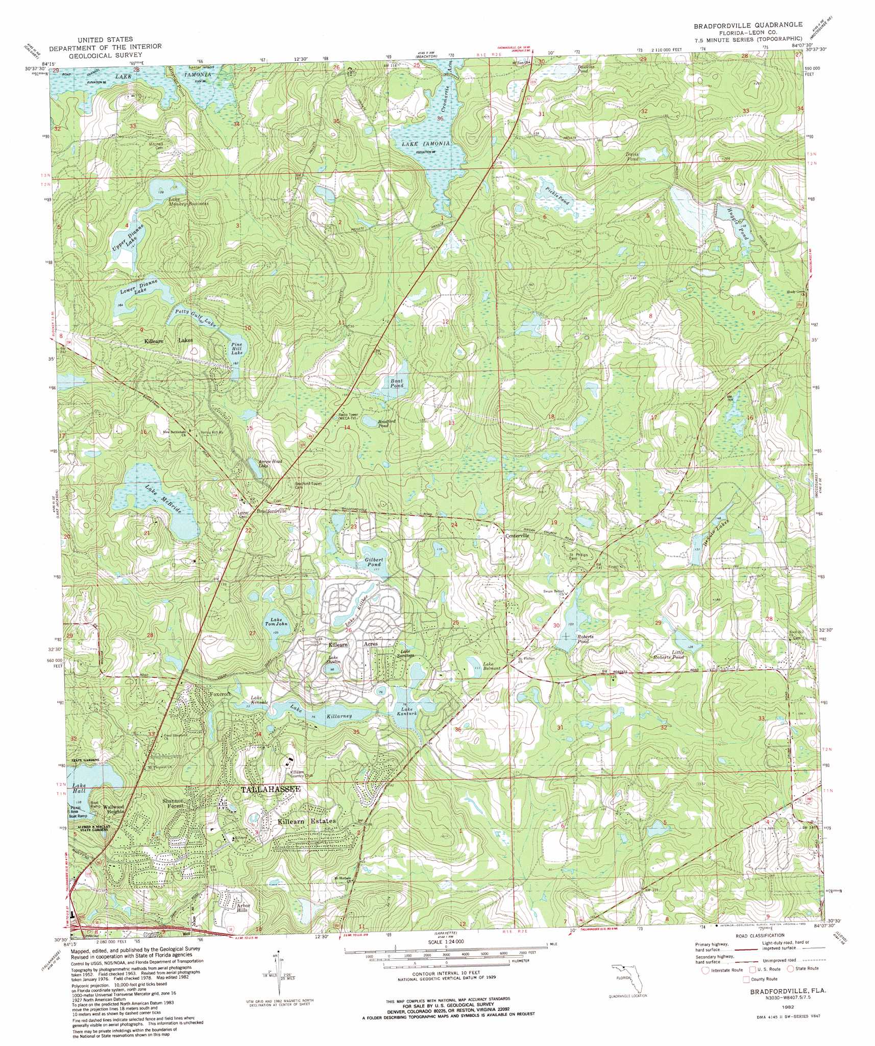
Bradfordville Topo Map Florida
To zoom in, hover over the map of Bradfordville
USGS Topo Quad 30084e2 - 1:24,000 scale
| Topo Map Name: | Bradfordville |
| USGS Topo Quad ID: | 30084e2 |
| Print Size: | ca. 21 1/4" wide x 27" high |
| Southeast Coordinates: | 30.5° N latitude / 84.125° W longitude |
| Map Center Coordinates: | 30.5625° N latitude / 84.1875° W longitude |
| U.S. State: | FL |
| Filename: | O30084E2.jpg |
| Download Map JPG Image: | Bradfordville topo map 1:24,000 scale |
| Map Type: | Topographic |
| Topo Series: | 7.5´ |
| Map Scale: | 1:24,000 |
| Source of Map Images: | United States Geological Survey (USGS) |
| Alternate Map Versions: |
Bradfordville FL 1963, updated 1964 Download PDF Buy paper map Bradfordville FL 1982, updated 1983 Download PDF Buy paper map Bradfordville FL 1999, updated 2004 Download PDF Buy paper map Bradfordville FL 2012 Download PDF Buy paper map Bradfordville FL 2015 Download PDF Buy paper map |
1:24,000 Topo Quads surrounding Bradfordville
Climax South |
Reno |
Cairo South |
Pine Park |
Thomasville |
Havana North |
Calvary |
Beachton |
Miccosukee Ne |
Metcalf |
Havana South |
Lake Jackson |
Bradfordville |
Miccosukee |
Lake Miccosukee |
Midway |
Tallahassee |
Lafayette |
Lloyd |
Waukeenah |
Hilliardville |
Lake Munson |
Woodville |
Cody |
Wacissa |
> Back to 30084e1 at 1:100,000 scale
> Back to 30084a1 at 1:250,000 scale
> Back to U.S. Topo Maps home
Bradfordville topo map: Gazetteer
Bradfordville: Bays
Cromartie Arm elevation 30m 98′Bradfordville: Lakes
Boat Pond elevation 42m 137′Bradford Pond elevation 42m 137′
Davis Pond elevation 42m 137′
Dawkins Pond elevation 28m 91′
Huggle Pond elevation 45m 147′
Lake Belmont elevation 34m 111′
Lake Hall elevation 42m 137′
Lake Kanturk elevation 23m 75′
Lake Killarney elevation 23m 75′
Lake Killkee elevation 35m 114′
Lake Kinsale elevation 23m 75′
Lake McBride elevation 43m 141′
Lake Monkey Business elevation 39m 127′
Lake Saratoga elevation 23m 75′
Lake Sheelin elevation 30m 98′
Lake Tom John elevation 32m 104′
Lower Dianne Lake elevation 50m 164′
Petty Gulf Lake elevation 55m 180′
Pickle Pond elevation 34m 111′
Pine Hill Lake elevation 55m 180′
Upper Dianne Lake elevation 43m 141′
Bradfordville: Populated Places
Bradfordville elevation 68m 223′Centerville elevation 53m 173′
Bradfordville: Reservoirs
Gilbert Pond elevation 33m 108′Little Roberts Pond elevation 39m 127′
Roberts Pond elevation 31m 101′
Bradfordville digital topo map on disk
Buy this Bradfordville topo map showing relief, roads, GPS coordinates and other geographical features, as a high-resolution digital map file on DVD:
Gulf Coast (LA, MS, AL, FL) & Southwestern Georgia
Buy digital topo maps: Gulf Coast (LA, MS, AL, FL) & Southwestern Georgia
 & Southwestern Georgia map DVD")