Lake Jackson Topo Map Florida
To zoom in, hover over the map of Lake Jackson
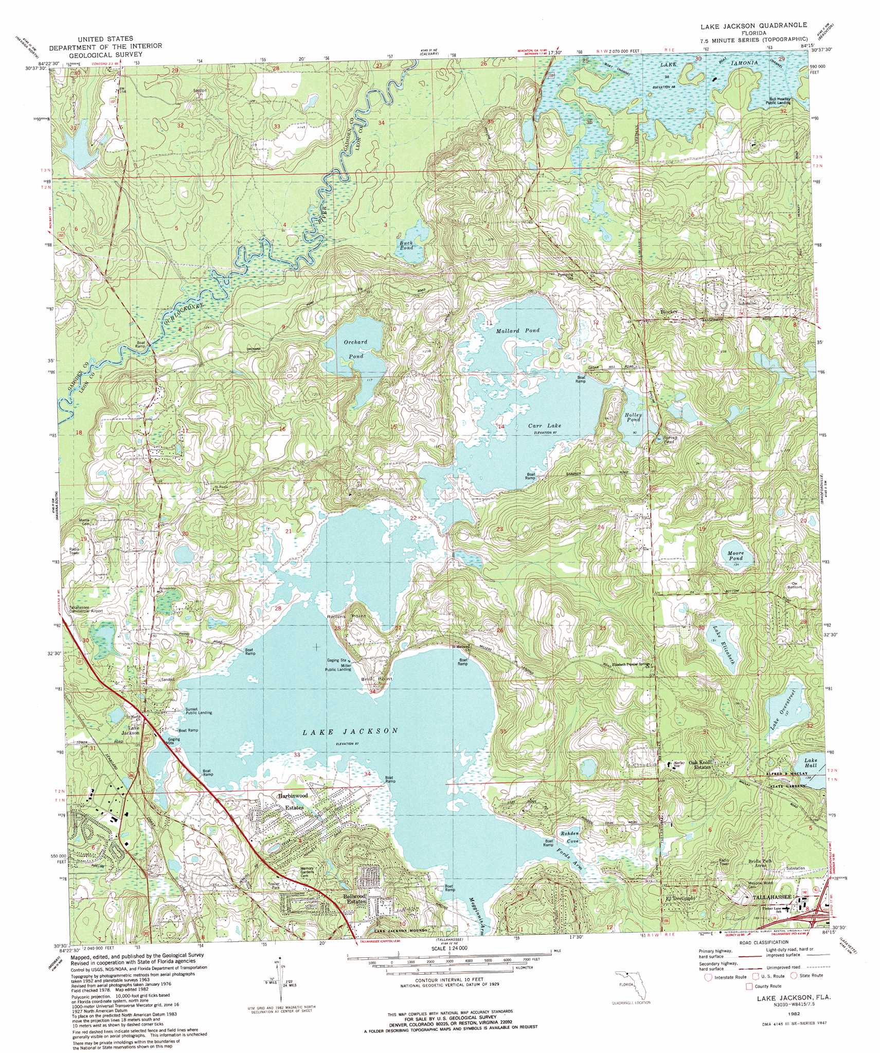
USGS Topo Quad 30084e3 - 1:24,000 scale
| Topo Map Name: | Lake Jackson |
| USGS Topo Quad ID: | 30084e3 |
| Print Size: | ca. 21 1/4" wide x 27" high |
| Southeast Coordinates: | 30.5° N latitude / 84.25° W longitude |
| Map Center Coordinates: | 30.5625° N latitude / 84.3125° W longitude |
| U.S. State: | FL |
| Filename: | O30084E3.jpg |
| Download Map JPG Image: | Lake Jackson topo map 1:24,000 scale |
| Map Type: | Topographic |
| Topo Series: | 7.5´ |
| Map Scale: | 1:24,000 |
| Source of Map Images: | United States Geological Survey (USGS) |
| Alternate Map Versions: |
Lake Jackson FL 1963, updated 1964 Download PDF Buy paper map Lake Jackson FL 1982, updated 1983 Download PDF Buy paper map Lake Jackson FL 1982, updated 1983 Download PDF Buy paper map Lake Jackson FL 1999, updated 2003 Download PDF Buy paper map Lake Jackson FL 2012 Download PDF Buy paper map Lake Jackson FL 2015 Download PDF Buy paper map |
1:24,000 Topo Quads surrounding Lake Jackson
Fowlstown |
Climax South |
Reno |
Cairo South |
Pine Park |
Dogtown |
Havana North |
Calvary |
Beachton |
Miccosukee Ne |
Quincy |
Havana South |
Lake Jackson |
Bradfordville |
Miccosukee |
Lake Talquin |
Midway |
Tallahassee |
Lafayette |
Lloyd |
Lake Talquin Se |
Hilliardville |
Lake Munson |
Woodville |
Cody |
> Back to 30084e1 at 1:100,000 scale
> Back to 30084a1 at 1:250,000 scale
> Back to U.S. Topo Maps home
Lake Jackson topo map: Gazetteer
Lake Jackson: Airports
Tallahassee Commercial Airport elevation 44m 144′Lake Jackson: Basins
Ox Bottom elevation 35m 114′Lake Jackson: Bays
Fords Arm elevation 26m 85′Rohden Cove elevation 26m 85′
Lake Jackson: Capes
Brill Point elevation 42m 137′Rollins Point elevation 46m 150′
Lake Jackson: Lakes
Buck Pond elevation 29m 95′Carr Lake elevation 26m 85′
Holley Pond elevation 27m 88′
Lake Elizabeth elevation 46m 150′
Lake Jackson elevation 26m 85′
Lake Overstreet elevation 42m 137′
Mallard Pond elevation 26m 85′
Moore Pond elevation 41m 134′
Orchard Pond elevation 35m 114′
Spring Pond elevation 29m 95′
Lake Jackson: Parks
Alfred B Maclay Gardens State Park elevation 46m 150′Elinor Knapp-Phipps Park elevation 46m 150′
Forestmeadows Park elevation 72m 236′
Killearn Gardens State Park elevation 56m 183′
Old Bainbridge County Park elevation 42m 137′
Stoneler Road County Park elevation 31m 101′
Lake Jackson: Populated Places
Bellwood Estates elevation 68m 223′Blocker elevation 79m 259′
Bridle Path Acres elevation 68m 223′
El Destinado elevation 44m 144′
Harbinwood Estates elevation 44m 144′
Lake Jackson elevation 36m 118′
Oak Knoll Estates elevation 52m 170′
Lake Jackson digital topo map on disk
Buy this Lake Jackson topo map showing relief, roads, GPS coordinates and other geographical features, as a high-resolution digital map file on DVD:
Gulf Coast (LA, MS, AL, FL) & Southwestern Georgia
Buy digital topo maps: Gulf Coast (LA, MS, AL, FL) & Southwestern Georgia
 & Southwestern Georgia map DVD")