Chattahoochee Topo Map Florida
To zoom in, hover over the map of Chattahoochee
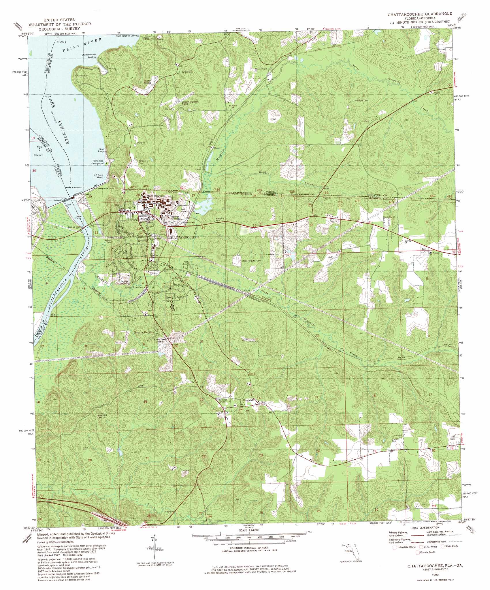
USGS Topo Quad 30084f7 - 1:24,000 scale
| Topo Map Name: | Chattahoochee |
| USGS Topo Quad ID: | 30084f7 |
| Print Size: | ca. 21 1/4" wide x 27" high |
| Southeast Coordinates: | 30.625° N latitude / 84.75° W longitude |
| Map Center Coordinates: | 30.6875° N latitude / 84.8125° W longitude |
| U.S. States: | FL, GA |
| Filename: | O30084F7.jpg |
| Download Map JPG Image: | Chattahoochee topo map 1:24,000 scale |
| Map Type: | Topographic |
| Topo Series: | 7.5´ |
| Map Scale: | 1:24,000 |
| Source of Map Images: | United States Geological Survey (USGS) |
| Alternate Map Versions: |
Chattahoochee FL 1955, updated 1956 Download PDF Buy paper map Chattahoochee FL 1955, updated 1972 Download PDF Buy paper map Chattahoochee FL 1982, updated 1983 Download PDF Buy paper map Chattahoochee FL 1994, updated 1998 Download PDF Buy paper map Chattahoochee FL 2011 Download PDF Buy paper map Chattahoochee FL 2012 Download PDF Buy paper map Chattahoochee FL 2015 Download PDF Buy paper map |
1:24,000 Topo Quads surrounding Chattahoochee
Bascom |
Steam Mill |
Desser |
Brinson |
Bainbridge |
Dellwood |
Fairchild |
Reynoldsville |
Faceville |
Fowlstown |
Cypress |
Sneads |
Chattahoochee |
Mount Pleasant |
Dogtown |
Altha East |
Rock Bluff |
Sycamore |
Gretna |
Quincy |
Blountstown |
Bristol |
Hosford |
Bloxham |
Lake Talquin |
> Back to 30084e1 at 1:100,000 scale
> Back to 30084a1 at 1:250,000 scale
> Back to U.S. Topo Maps home
Chattahoochee topo map: Gazetteer
Chattahoochee: Airports
Corps of Engineers Airport elevation 70m 229′Florida State Hospital Heliport elevation 72m 236′
Widdon Airstrip elevation 68m 223′
Chattahoochee: Bridges
Victory Bridge elevation 17m 55′Chattahoochee: Dams
Jim Woodruff Dam elevation 14m 45′Chattahoochee: Populated Places
Chattahoochee elevation 72m 236′Hardin Heights elevation 56m 183′
Jinks elevation 29m 95′
River Junction elevation 22m 72′
Rosedale elevation 84m 275′
Chattahoochee: Reservoirs
Lake Seminole elevation 14m 45′Chattahoochee: Streams
Boykin Branch elevation 26m 85′Chattahoochee River elevation 16m 52′
Flint River elevation 16m 52′
Mosquito Creek elevation 14m 45′
North Mosquito Creek elevation 21m 68′
South Mosquito Creek elevation 21m 68′
Yon Creek elevation 28m 91′
Chattahoochee digital topo map on disk
Buy this Chattahoochee topo map showing relief, roads, GPS coordinates and other geographical features, as a high-resolution digital map file on DVD:
Gulf Coast (LA, MS, AL, FL) & Southwestern Georgia
Buy digital topo maps: Gulf Coast (LA, MS, AL, FL) & Southwestern Georgia
 & Southwestern Georgia map DVD")