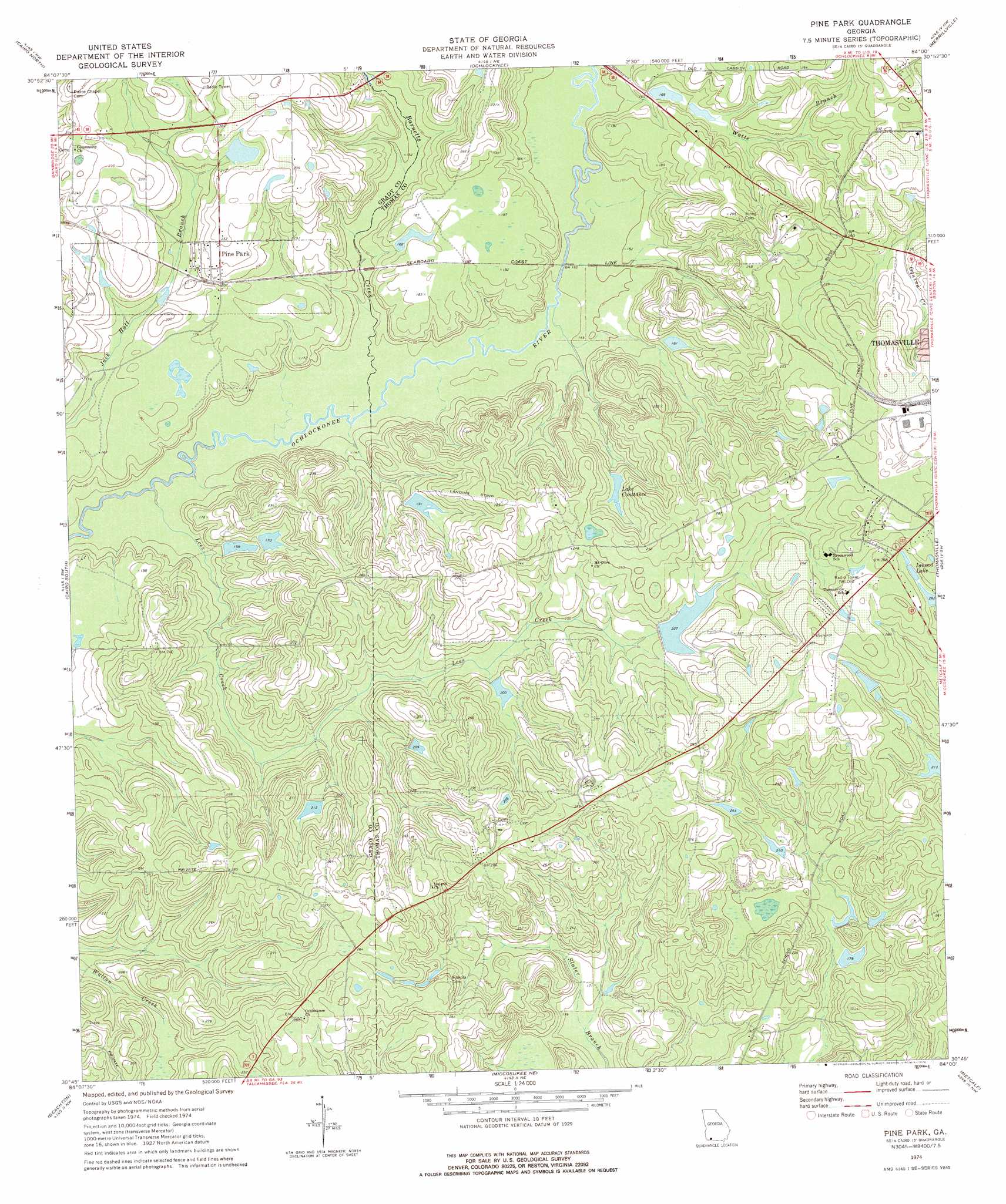
Pine Park Topo Map Georgia
To zoom in, hover over the map of Pine Park
USGS Topo Quad 30084g1 - 1:24,000 scale
| Topo Map Name: | Pine Park |
| USGS Topo Quad ID: | 30084g1 |
| Print Size: | ca. 21 1/4" wide x 27" high |
| Southeast Coordinates: | 30.75° N latitude / 84° W longitude |
| Map Center Coordinates: | 30.8125° N latitude / 84.0625° W longitude |
| U.S. State: | GA |
| Filename: | o30084g1.jpg |
| Download Map JPG Image: | Pine Park topo map 1:24,000 scale |
| Map Type: | Topographic |
| Topo Series: | 7.5´ |
| Map Scale: | 1:24,000 |
| Source of Map Images: | United States Geological Survey (USGS) |
| Alternate Map Versions: |
Pine Park GA 1974, updated 1976 Download PDF Buy paper map Pine Park GA 2011 Download PDF Buy paper map Pine Park GA 2014 Download PDF Buy paper map |
1:24,000 Topo Quads surrounding Pine Park
Gee Pond |
Pelham |
Meigs |
Chastain |
Coolidge |
Whigham |
Cairo North |
Ochlocknee |
Merrillville |
Patten |
Reno |
Cairo South |
Pine Park |
Thomasville |
Boston |
Calvary |
Beachton |
Miccosukee Ne |
Metcalf |
Monticello Ne |
Lake Jackson |
Bradfordville |
Miccosukee |
Lake Miccosukee |
Monticello |
> Back to 30084e1 at 1:100,000 scale
> Back to 30084a1 at 1:250,000 scale
> Back to U.S. Topo Maps home
Pine Park topo map: Gazetteer
Pine Park: Airports
Winstead Plantation Airport elevation 73m 239′Pine Park: Dams
Bricknell Lake Dam elevation 70m 229′Cheek Lake Dam elevation 55m 180′
Greenwood Lake Dam elevation 51m 167′
Lake Constance Dam elevation 64m 209′
Melrose Plantation Lake Dam elevation 62m 203′
Oliver Lake Dam elevation 52m 170′
Scott Lake Dam elevation 52m 170′
Ward Lake Dam elevation 65m 213′
Winstead Plantation Lake Dam elevation 58m 190′
Pine Park: Populated Places
Mount Olive (historical) elevation 74m 242′Pebble Hill elevation 82m 269′
Pine Park elevation 66m 216′
Pine Park: Reservoirs
Bricknell Lake elevation 70m 229′Cheek Lake elevation 55m 180′
Constance Lake elevation 64m 209′
Greenwood Lake elevation 51m 167′
Inwood Lake elevation 81m 265′
Lake Constance elevation 66m 216′
Melrose Plantation Lake elevation 62m 203′
Oliver Lake elevation 52m 170′
Scott Lake elevation 52m 170′
Ward Lake elevation 65m 213′
Winstead Plantation Lake elevation 58m 190′
Pine Park: Streams
Barnetts Creek elevation 41m 134′Lees Creek elevation 39m 127′
Wards Creek elevation 79m 259′
Watts Branch elevation 45m 147′
Pine Park digital topo map on disk
Buy this Pine Park topo map showing relief, roads, GPS coordinates and other geographical features, as a high-resolution digital map file on DVD:
Gulf Coast (LA, MS, AL, FL) & Southwestern Georgia
Buy digital topo maps: Gulf Coast (LA, MS, AL, FL) & Southwestern Georgia
 & Southwestern Georgia map DVD")