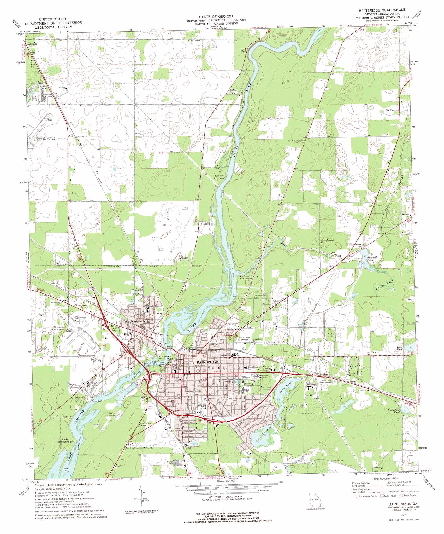
Bainbridge Topo Map Georgia
To zoom in, hover over the map of Bainbridge
USGS Topo Quad 30084h5 - 1:24,000 scale
| Topo Map Name: | Bainbridge |
| USGS Topo Quad ID: | 30084h5 |
| Print Size: | ca. 21 1/4" wide x 27" high |
| Southeast Coordinates: | 30.875° N latitude / 84.5° W longitude |
| Map Center Coordinates: | 30.9375° N latitude / 84.5625° W longitude |
| U.S. State: | GA |
| Filename: | o30084h5.jpg |
| Download Map JPG Image: | Bainbridge topo map 1:24,000 scale |
| Map Type: | Topographic |
| Topo Series: | 7.5´ |
| Map Scale: | 1:24,000 |
| Source of Map Images: | United States Geological Survey (USGS) |
| Alternate Map Versions: |
Bainbridge GA 1974, updated 1976 Download PDF Buy paper map Bainbridge GA 2011 Download PDF Buy paper map Bainbridge GA 2014 Download PDF Buy paper map |
1:24,000 Topo Quads surrounding Bainbridge
Donalsonville Ne |
Colquitt |
Cooktown |
Hopeful |
Branchville |
Donalsonville East |
Boykin |
Steadhams Store |
Vada |
Gee Pond |
Desser |
Brinson |
Bainbridge |
Climax North |
Whigham |
Reynoldsville |
Faceville |
Fowlstown |
Climax South |
Reno |
Chattahoochee |
Mount Pleasant |
Dogtown |
Havana North |
Calvary |
> Back to 30084e1 at 1:100,000 scale
> Back to 30084a1 at 1:250,000 scale
> Back to U.S. Topo Maps home
Bainbridge topo map: Gazetteer
Bainbridge: Airports
Memorial Hospital Heliport elevation 37m 121′Bainbridge: Bends
Little Horseshoe Bend elevation 25m 82′Bainbridge: Bridges
Culbreth Bridge elevation 23m 75′Bainbridge: Cliffs
Red Bluff elevation 37m 121′Bainbridge: Lakes
Bateau Pond elevation 27m 88′Black Jack Pond elevation 39m 127′
Fourmile Pond elevation 27m 88′
Lake Douglas elevation 29m 95′
Long Pond elevation 32m 104′
Twin Lakes elevation 29m 95′
Bainbridge: Parks
Bainbridge Commercial Historic District elevation 39m 127′Bainbridge Residential Historic District elevation 36m 118′
Bainbridge State Park elevation 25m 82′
Chason Park elevation 38m 124′
Cheney Griffen Park elevation 29m 95′
College Street Park elevation 36m 118′
Decatur County Memorial Coliseum elevation 36m 118′
Earle May Park elevation 24m 78′
Helen Street Park elevation 36m 118′
Lake Drive Park elevation 32m 104′
Pineland Drive Park elevation 33m 108′
Washington Street Park elevation 38m 124′
Willis Park elevation 39m 127′
Bainbridge: Populated Places
Ausmac elevation 36m 118′Bainbridge elevation 37m 121′
Lynn elevation 40m 131′
Mount Pleasant elevation 40m 131′
West Bainbridge elevation 30m 98′
Bainbridge: Post Offices
Bainbridge Post Office elevation 36m 118′West Bainbridge Post Office elevation 31m 101′
Bainbridge: Streams
Big Slough elevation 27m 88′Bainbridge digital topo map on disk
Buy this Bainbridge topo map showing relief, roads, GPS coordinates and other geographical features, as a high-resolution digital map file on DVD:
Gulf Coast (LA, MS, AL, FL) & Southwestern Georgia
Buy digital topo maps: Gulf Coast (LA, MS, AL, FL) & Southwestern Georgia
 & Southwestern Georgia map DVD")